File:Papal States 1849 map-es.svg
Jump to navigation
Jump to search

Size of this PNG preview of this SVG file: 533 × 600 pixels. Other resolutions: 213 × 240 pixels | 427 × 480 pixels | 683 × 768 pixels | 910 × 1,024 pixels | 1,820 × 2,048 pixels | 960 × 1,080 pixels.
Original file (SVG file, nominally 960 × 1,080 pixels, file size: 379 KB)
Captions
Captions
Add a one-line explanation of what this file represents
Summary[edit]
| Description |
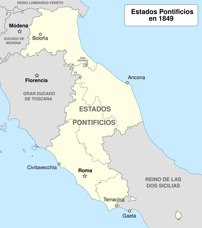
English: Map showing the Papal States in 1849.
Español: Mapa de los Estados Pontificios en 1849. |
| Date | |
| Source | Own work. Source : * Background from : File:Legation_of_Marittima_and_Campagna_Location.svg by AnRo0002 under licence GFDL or CC-BY-SA 3.0 |
| Author | Sémhur (talk) |
| Other versions | File:Papal States 1849 map-fr.svg |
Licensing[edit]
I, the copyright holder of this work, hereby publish it under the following licenses:

|
Permission is granted to copy, distribute and/or modify this document under the terms of the GNU Free Documentation License, Version 1.2 or any later version published by the Free Software Foundation; with no Invariant Sections, no Front-Cover Texts, and no Back-Cover Texts. A copy of the license is included in the section entitled GNU Free Documentation License. |
This file is licensed under the Creative Commons Attribution-Share Alike 4.0 International, 3.0 Unported, 2.5 Generic, 2.0 Generic and 1.0 Generic license.
- You are free:
- to share – to copy, distribute and transmit the work
- to remix – to adapt the work
- Under the following conditions:
- attribution – You must give appropriate credit, provide a link to the license, and indicate if changes were made. You may do so in any reasonable manner, but not in any way that suggests the licensor endorses you or your use.
- share alike – If you remix, transform, or build upon the material, you must distribute your contributions under the same or compatible license as the original.
You may select the license of your choice.
File history
Click on a date/time to view the file as it appeared at that time.
| Date/Time | Thumbnail | Dimensions | User | Comment | |
|---|---|---|---|---|---|
| current | 07:12, 25 July 2012 | | 960 × 1,080 (379 KB) | Andreasmperu (talk | contribs) | Tipografía |
| 07:10, 25 July 2012 |  | 960 × 1,080 (379 KB) | Andreasmperu (talk | contribs) | {{Information |Description ={{en|1=Map showing the Papal States in 1849.}} {{es|1=Mapa de los Estados Pontificios en 1849.}} |Source ={{own}}. Source : * Background from : [[:File:Legation_of_... |
You cannot overwrite this file.
File usage on Commons
The following 2 pages use this file:
File usage on other wikis
The following other wikis use this file:
- Usage on ar.wikipedia.org
- Usage on ast.wikipedia.org
- Usage on az.wikipedia.org
- Usage on es.wikipedia.org
- Usage on eu.wikipedia.org
- Usage on ja.wikipedia.org
- Usage on ro.wikipedia.org
- Usage on www.wikidata.org