File:PIA11178 - The Contrasting Colors of Crater Dunes and Gullies.jpg

Original file (4,500 × 3,000 pixels, file size: 15.71 MB, MIME type: image/jpeg)
Captions
Captions
|
Summary[edit]
| Description |
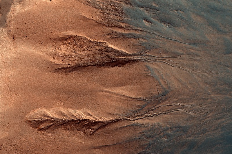
English: Gullies are relatively common features in the steep slopes of crater walls, possibly formed by dry debris flows, movement of carbon dioxide frost, or perhaps the melting of ground ice.
This example shows a section of crater wall from the rocky crater rim at the far left of the image, down to the dark dusty dunes on the crater floor in the bottom right. (North is to the left.) The rock of the crater walls shows up deep orange, and the sandy deposits on the crater floor and the base of the crater walls appear blue. The sand isn’t really blue; the different colors in this image represent different material compositions. The gullies in this image have two main sections: a scalloped alcove at the top of the gully (left/center), and defined channel sections further down the crater wall (right/center). Material from the alcove will have traveled down the channel to the crater floor. This normally forms a third section to a typical gully, a debris fan. Fans commonly visible at the base of gullies are not obvious in this example however, as the wind blown sediments (blue) have covered the crater floor after gully formation. The University of Arizona, Tucson, operates HiRISE, which was built by Ball Aerospace & Technologies Corp., Boulder, Colo. NASA's Jet Propulsion Laboratory, a division of Caltech in Pasadena, California, manages the Mars Reconnaissance Orbiter Project for NASA's Science Mission Directorate, Washington. |
| Date | 15 January 2011 (published 2 February 2016) |
| Source | Catalog page · Full-res (JPEG · TIFF) |
| Author | NASA/JPL-Caltech/Univ. of Arizona |
| Location on Mars | View this and other nearby images on: Google Maps |
|---|
This image or video was catalogued by Jet Propulsion Laboratory of the United States National Aeronautics and Space Administration (NASA) under Photo ID: PIA11178. This tag does not indicate the copyright status of the attached work. A normal copyright tag is still required. See Commons:Licensing. Other languages:
|
 |
This media is a product of the Mars Reconnaissance Orbiter mission Credit and attribution belongs to the High Resolution Imaging Science Experiment (HiRISE) team, NASA/JPL-Caltech/Univ. of Arizona |
Licensing[edit]
| This file is in the public domain in the United States because it was solely created by NASA. NASA copyright policy states that "NASA material is not protected by copyright unless noted". (See Template:PD-USGov, NASA copyright policy page or JPL Image Use Policy.) | ||
 |
Warnings:
|
File history
Click on a date/time to view the file as it appeared at that time.
| Date/Time | Thumbnail | Dimensions | User | Comment | |
|---|---|---|---|---|---|
| current | 17:26, 7 January 2019 | | 4,500 × 3,000 (15.71 MB) | Kesäperuna (talk | contribs) | 100% JPEG quality from full quality TIFF. |
| 21:11, 3 February 2017 |  | 4,500 × 3,000 (2.3 MB) | PhilipTerryGraham (talk | contribs) | User created page with UploadWizard |
You cannot overwrite this file.
File usage on Commons
The following 16 pages use this file:
- Featured Photographs in the Public Domain
- User:Hidayatsrf/Gallery
- User:Meiræ/18
- User:Nigreco451/FPGallery
- Commons:Featured picture candidates/File:PIA11178 - The Contrasting Colors of Crater Dunes and Gullies.jpg
- Commons:Featured picture candidates/Log/March 2017
- Commons:Featured pictures/Astronomy
- Commons:Featured pictures/chronological/2017-A
- Commons:Picture of the Year/2017/Candidates
- Commons:Picture of the Year/2017/R1/Gallery/2017-A
- Commons:Picture of the Year/2017/R1/Gallery/ALL
- Commons:Picture of the Year/2017/R1/Gallery/Astronomy
- Commons:Picture of the Year/2017/R1/Gallery/M03
- Commons:Picture of the Year/2017/R1/v/PIA11178 - The Contrasting Colors of Crater Dunes and Gullies.jpg
- Commons:WikiProject Aviation/recent uploads/2017 February 3/Overflow 1
- Commons:WikiProject Aviation/recent uploads/2019 January 7
File usage on other wikis
The following other wikis use this file:
- Usage on bg.wikipedia.org
- Usage on en.wikipedia.org
- Usage on fr.wikipedia.org
- Usage on incubator.wikimedia.org
- Usage on nl.wikipedia.org
- Usage on sk.wikipedia.org