File:OV-Knooppunt Leyenburg.png
Jump to navigation
Jump to search
Size of this preview: 800 × 514 pixels. Other resolutions: 320 × 205 pixels | 640 × 411 pixels | 1,024 × 658 pixels | 1,280 × 822 pixels | 2,501 × 1,606 pixels.
Original file (2,501 × 1,606 pixels, file size: 3.91 MB, MIME type: image/png)
Captions
Captions
Add a one-line explanation of what this file represents
Summary[edit]
| Description |
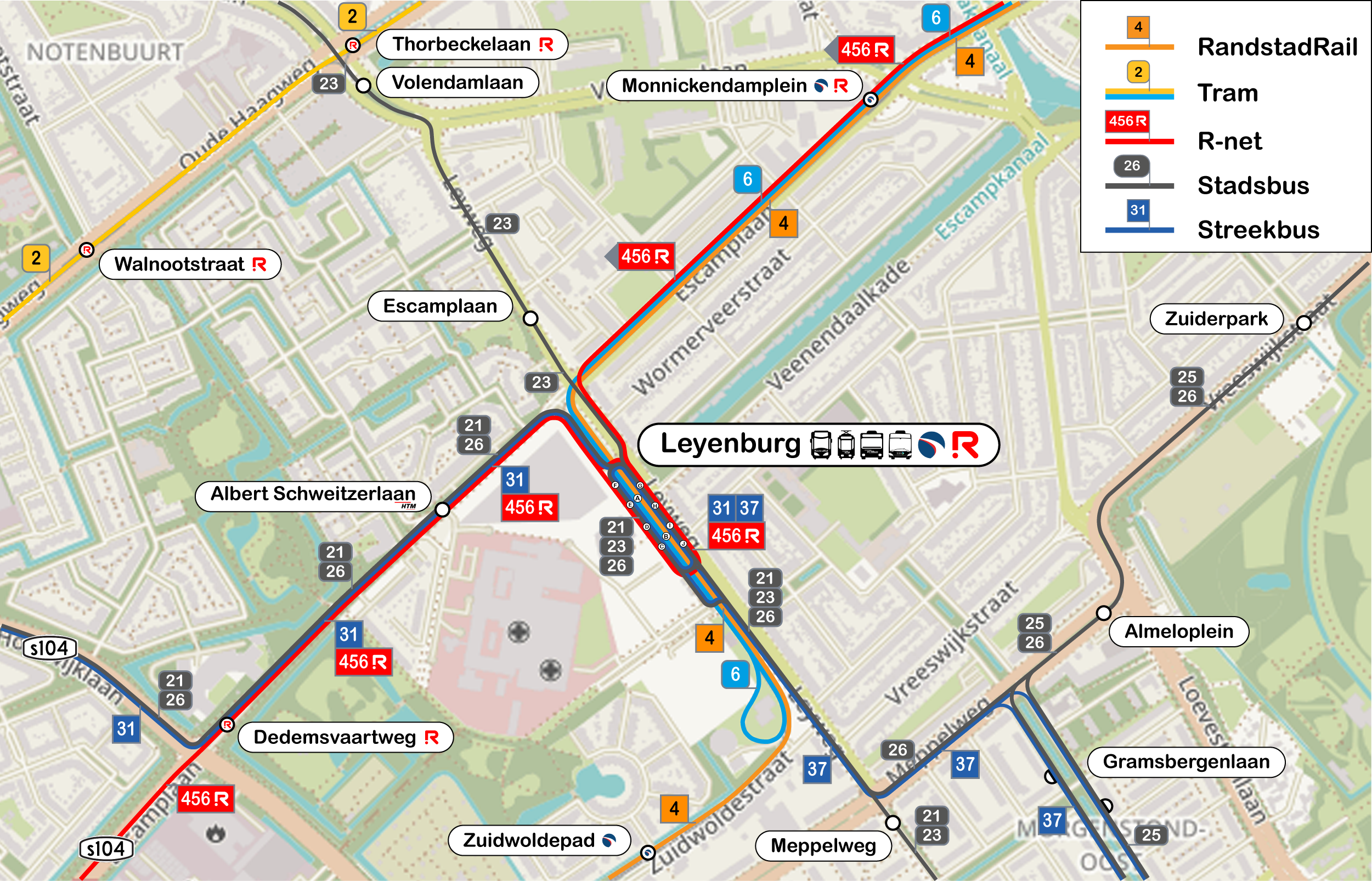
Nederlands: Dit is de omgeving van het OV-knooppunt Leyenburg. English: This is the area surrounding the public transport node leyenburg. |
| Source | self-made, based on cc-by-sa map openstreetmap |
| Author | OpenStreetmap, Cornepronk |
Licensing[edit]
I, the copyright holder of this work, hereby publish it under the following license:
This file is licensed under the Creative Commons Attribution-Share Alike 3.0 Unported license.
- You are free:
- to share – to copy, distribute and transmit the work
- to remix – to adapt the work
- Under the following conditions:
- attribution – You must give appropriate credit, provide a link to the license, and indicate if changes were made. You may do so in any reasonable manner, but not in any way that suggests the licensor endorses you or your use.
- share alike – If you remix, transform, or build upon the material, you must distribute your contributions under the same or compatible license as the original.
File history
Click on a date/time to view the file as it appeared at that time.
| Date/Time | Thumbnail | Dimensions | User | Comment | |
|---|---|---|---|---|---|
| current | 13:18, 13 June 2021 | | 2,501 × 1,606 (3.91 MB) | Cornepronk (talk | contribs) | Aangepaste lijnen en routes |
| 02:06, 7 March 2021 |  | 5,210 × 3,344 (8.83 MB) | Cornepronk (talk | contribs) | Aangepaste lijnen en routes | |
| 05:20, 10 November 2020 |  | 2,500 × 1,607 (3.89 MB) | Cornepronk (talk | contribs) | Aangepaste lijnen en routes | |
| 11:59, 25 September 2019 |  | 2,501 × 1,605 (3.82 MB) | Cornepronk (talk | contribs) | Pictogram streekbus aanpassen | |
| 03:26, 25 September 2019 |  | 2,501 × 1,605 (3.82 MB) | Cornepronk (talk | contribs) | Wegnummers erbij zoals s104. | |
| 02:16, 10 September 2019 |  | 2,501 × 1,605 (3.86 MB) | Cornepronk (talk | contribs) | Betere legenda | |
| 02:07, 10 September 2019 |  | 2,501 × 1,605 (3.87 MB) | Cornepronk (talk | contribs) | Betere legenda | |
| 17:23, 29 August 2019 |  | 2,501 × 1,605 (3.88 MB) | Cornepronk (talk | contribs) | Niewe situatie sinds 25 augustus 2019 | |
| 14:00, 14 July 2018 |  | 2,501 × 1,605 (3.9 MB) | Cornepronk (talk | contribs) | New version | |
| 13:53, 14 July 2018 |  | 2,501 × 1,605 (3.9 MB) | Cornepronk (talk | contribs) | New version |
You cannot overwrite this file.
File usage on Commons
The following 19 pages use this file:
- User:Chumwa/OgreBot/Potential transport maps/2019 August 21-31
- User:Chumwa/OgreBot/Potential transport maps/2019 September 1-10
- User:Chumwa/OgreBot/Potential transport maps/2019 September 21-30
- User:Chumwa/OgreBot/Public transport information/2019 August 21-31
- User:Chumwa/OgreBot/Public transport information/2019 September 1-10
- User:Chumwa/OgreBot/Public transport information/2019 September 21-30
- User:Chumwa/OgreBot/Public transport information/2020 November 1-10
- User:Chumwa/OgreBot/Public transport information/2021 June 11-20
- User:Chumwa/OgreBot/Public transport information/2021 March 1-10
- User:Chumwa/OgreBot/Transport Maps/2019 August 21-31
- User:Chumwa/OgreBot/Transport Maps/2019 September 1-10
- User:Chumwa/OgreBot/Transport Maps/2019 September 21-30
- User:Chumwa/OgreBot/Transport Maps/2020 November 1-10
- User:Chumwa/OgreBot/Transport Maps/2021 June 11-20
- User:Chumwa/OgreBot/Transport Maps/2021 March 1-10
- User:Chumwa/OgreBot/Travel and communication maps/2019 August 21-31
- User:Chumwa/OgreBot/Travel and communication maps/2019 September 1-10
- User:Chumwa/OgreBot/Travel and communication maps/2019 September 21-30
- Category:Leyenburg (public transport stop)
File usage on other wikis
The following other wikis use this file:
- Usage on nl.wikipedia.org
- Usage on www.wikidata.org