File:Norway Svalbard regions and lands.jpg
Jump to navigation
Jump to search
No higher resolution available.
Norway_Svalbard_regions_and_lands.jpg (427 × 379 pixels, file size: 38 KB, MIME type: image/jpeg)
Captions
Captions
Add a one-line explanation of what this file represents
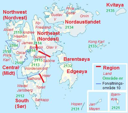
| Description | Map of Svalbard and Jan Mayen, with denotions of Nature Regions (bold red), "Land" names, ex.: Bünsow means "Bünsow Land" (italic red), Area codes (Område-nr) (bold green), Management Area 10 (Forvaltningsområde 10) (blue line). Management Area 10 is the area where visitors can roam without special insurance and without having to notify the Governor of Svalbard. |
| Date | (UTC) |
| Source | |
| Author |
|
| Permission (Reusing this file) |
ccbysa-3.0 |
| This is a retouched picture, which means that it has been digitally altered from its original version. Modifications: Added region names, "Land" names, and area codes. The original can be viewed here: Norway Svalbard location map.svg:
|
I, the copyright holder of this work, hereby publish it under the following licenses:
This file is licensed under the Creative Commons Attribution-Share Alike 3.0 Unported license.
- You are free:
- to share – to copy, distribute and transmit the work
- to remix – to adapt the work
- Under the following conditions:
- attribution – You must give appropriate credit, provide a link to the license, and indicate if changes were made. You may do so in any reasonable manner, but not in any way that suggests the licensor endorses you or your use.
- share alike – If you remix, transform, or build upon the material, you must distribute your contributions under the same or compatible license as the original.

|
Permission is granted to copy, distribute and/or modify this document under the terms of the GNU Free Documentation License, Version 1.2 or any later version published by the Free Software Foundation; with no Invariant Sections, no Front-Cover Texts, and no Back-Cover Texts. A copy of the license is included in the section entitled GNU Free Documentation License. |
You may select the license of your choice.
Original upload log[edit]
This image is a derivative work of the following images:
- File:Norway_Svalbard_location_map.svg licensed with Cc-by-sa-3.0, GFDL
- 2009-08-16T19:15:01Z NordNordWest 1304x1825 (507370 Bytes)
- 2009-08-16T17:45:10Z NordNordWest 1304x1825 (507342 Bytes)
- 2009-08-16T16:53:16Z NordNordWest 1304x1825 (507342 Bytes) + Jan Mayen
- 2009-06-27T19:37:04Z NordNordWest 1304x1825 (514100 Bytes) c
- 2009-06-27T19:27:49Z NordNordWest 1304x1825 (514011 Bytes) + ice
- 2008-09-02T09:51:06Z NordNordWest 1304x1825 (208425 Bytes)
- 2008-06-30T19:24:45Z NordNordWest 1304x1825 (140852 Bytes) {{Information |Description= {{de|Positionskarte von [[:de:Svalbard|Svalbard]], [[:de:Norwegen|Norwegen]]}} Quadratische Plattkarte, N-S-Streckung 500 %. Geographische Begrenzung der Karte: * N: 81.0° N * S: 74.2° N * W: 9.5
Uploaded with derivativeFX
File history
Click on a date/time to view the file as it appeared at that time.
| Date/Time | Thumbnail | Dimensions | User | Comment | |
|---|---|---|---|---|---|
| current | 19:59, 1 May 2011 | | 427 × 379 (38 KB) | Bjoertvedt (talk | contribs) | {{Information |Description={{de|Positionskarte von Svalbard, Norwegen}} Quadratische Plattkarte, N-S-Streckung 500 %. Geographische Begrenzung der Karte: * N: 81.0° N * S: 74.2° N * W: 9.5° O * O: 33.8° O Für [[:de:J |
You cannot overwrite this file.
File usage on Commons
There are no pages that use this file.
File usage on other wikis
The following other wikis use this file:
- Usage on de.wikipedia.org
- Usage on no.wikipedia.org