File:Nieuw Nederland and Nya Sverige.png
Jump to navigation
Jump to search

Size of this preview: 393 × 599 pixels. Other resolutions: 157 × 240 pixels | 420 × 640 pixels.
Original file (420 × 640 pixels, file size: 13 KB, MIME type: image/png)
Captions
Captions
Add a one-line explanation of what this file represents
Summary[edit]
| Description |
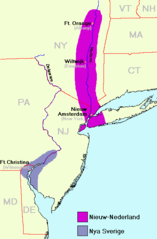
Deutsch: Karte von Neu-Niederland und Neu-Schweden um 1650. Erstellt auf Basis der Karten Delawares, New Jerseys und New Yorks der Perry Castañeda Library.
English: Map of New-Nederland and New-Sweden ca. 1650. Created on base of the maps of Delaware, New Jersey, and New York from the Perry Castañeda Library at //www.lib.utexas.edu/maps/united_states.html. |
| Date | circa 1650 |
| Source | http://www.lib.utexas.edu/maps/united_states.html |
| Author | Uploaded by User:Arnapha |
| Other versions | Derivative works of this file: Nieuw Nederland and Nya Sverige.svg |

|
File:Nieuw Nederland and Nya Sverige.svg is a vector version of this file. It should be used in place of this PNG file when not inferior.
File:Nieuw Nederland and Nya Sverige.png → File:Nieuw Nederland and Nya Sverige.svg
For more information, see Help:SVG. |
 |
Original upload log[edit]
Transferred from German Wikipedia (http://de.wikipedia.org/wiki/Bild:Neu_niederland_schweden.png)
Licensing[edit]
| I, the copyright holder of this work, release this work into the public domain. This applies worldwide. In some countries this may not be legally possible; if so: I grant anyone the right to use this work for any purpose, without any conditions, unless such conditions are required by law. |
File history
Click on a date/time to view the file as it appeared at that time.
| Date/Time | Thumbnail | Dimensions | User | Comment | |
|---|---|---|---|---|---|
| current | 05:03, 26 June 2009 | | 420 × 640 (13 KB) | Bogomolov.PL (talk | contribs) | CO => CT for the Connecticut |
| 18:56, 31 August 2005 |  | 420 × 640 (10 KB) | Arnapha (talk | contribs) | Map of New-Nederland and New-Sweden ca. 1650 Created on base of the maps of Delaware, New Jersey, and New York from the Perry Castañeda Library (at http://www.lib.utexas.edu/maps/united_states.html). Transferred from German Wikipedia (http://de.wikiped |
You cannot overwrite this file.
File usage on Commons
The following page uses this file:
File usage on other wikis
The following other wikis use this file: