File:Nidelvassdraget map.png
Jump to navigation
Jump to search

Size of this preview: 755 × 599 pixels. Other resolutions: 302 × 240 pixels | 605 × 480 pixels | 967 × 768 pixels | 1,280 × 1,016 pixels | 1,485 × 1,179 pixels.
Original file (1,485 × 1,179 pixels, file size: 114 KB, MIME type: image/png)
Captions
Captions
Add a one-line explanation of what this file represents
Summary[edit]
| Description |
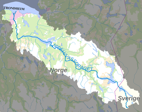
Svenska: Karta över Nidelvassdraget (Nean). Det markerade området är älevns avrinningsområde. |
| Date | |
| Source | Data derives from the Swedish National Land Survey (Lantmäteriet) (their data are CC-0) and the Norwegian Mapping and Cadastre Authority (Kartverket) (their data are CC-BY 4). |
| Author | Moralist |
Licensing[edit]
This file is licensed under the Creative Commons Attribution-Share Alike 4.0 International license.
- You are free:
- to share – to copy, distribute and transmit the work
- to remix – to adapt the work
- Under the following conditions:
- attribution – You must give appropriate credit, provide a link to the license, and indicate if changes were made. You may do so in any reasonable manner, but not in any way that suggests the licensor endorses you or your use.
- share alike – If you remix, transform, or build upon the material, you must distribute your contributions under the same or compatible license as the original.
File history
Click on a date/time to view the file as it appeared at that time.
| Date/Time | Thumbnail | Dimensions | User | Comment | |
|---|---|---|---|---|---|
| current | 19:02, 20 September 2017 | | 1,485 × 1,179 (114 KB) | Moralist (talk | contribs) | User created page with UploadWizard |
You cannot overwrite this file.
File usage on Commons
There are no pages that use this file.
File usage on other wikis
The following other wikis use this file:
- Usage on de.wikipedia.org
- Usage on es.wikipedia.org
- Usage on no.wikipedia.org
- Usage on pt.wikipedia.org
- Usage on sv.wikipedia.org