File:New Hampshire. LOC 79694562.jpg
Jump to navigation
Jump to search

Size of this preview: 372 × 600 pixels. Other resolutions: 149 × 240 pixels | 298 × 480 pixels | 476 × 768 pixels | 635 × 1,024 pixels | 1,270 × 2,048 pixels | 7,588 × 12,234 pixels.
Original file (7,588 × 12,234 pixels, file size: 9.74 MB, MIME type: image/jpeg)
Captions
Captions
Add a one-line explanation of what this file represents
Summary[edit]
| Warning | The original file is very high-resolution. It might not load properly or could cause your browser to freeze when opened at full size. |
|---|
| Description |
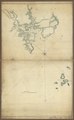
English: Scale ca. 1:24,000. Title from verso. Title in manuscript catalog of Peter Force map collection: Harbour of Portsmouth, N. Hampshire. Title in LC's Maps of America: Chart of coast of New Hampshire, near Portsmouth and the Isles of Shoals. Manuscript; pen-and-ink and watercolor. Mounted on cloth backing. Relief shown by hachures. Depths shown by soundings. LC Maps of North America, 1750-1789, 874 Available also through the Library of Congress Web site as a raster image. Vault AACR2 |
||
| Title | New Hampshire. | ||
| Shelf ID | G3744.P8P55 177- .N4 | ||
| Date | |||
| Source | https://www.loc.gov/item/79694562/ | ||
| Author | Unknown author | ||
| Permission (Reusing this file) |
|
||
| Other versions |
|
||
| Location | United States · Portsmouth · New Hampshire | ||
| Part of | Military Battles And Campaigns · American Memory · Catalog · Geography And Map Division · American Revolution And Its Era: Maps And Charts Of North America And The West Indies, 1750-1789 | ||
| Subject | Portsmouth · United States · Maps · Early Works To 1800 · New Hampshire · Harbors · Manuscript Maps |

Licensing[edit]
|
This is a faithful photographic reproduction of a two-dimensional, public domain work of art. The work of art itself is in the public domain for the following reason:
The official position taken by the Wikimedia Foundation is that "faithful reproductions of two-dimensional public domain works of art are public domain".
This photographic reproduction is therefore also considered to be in the public domain in the United States. In other jurisdictions, re-use of this content may be restricted; see Reuse of PD-Art photographs for details. | ||||
File history
Click on a date/time to view the file as it appeared at that time.
| Date/Time | Thumbnail | Dimensions | User | Comment | |
|---|---|---|---|---|---|
| current | 15:33, 21 June 2018 | | 7,588 × 12,234 (9.74 MB) | Fæ (talk | contribs) | LOC Maps https://www.loc.gov/item/79694562/ #23246 |
You cannot overwrite this file.
File usage on Commons
The following page uses this file: