File:Nauru land utilization-fr.png
Jump to navigation
Jump to search
Size of this preview: 553 × 599 pixels. Other resolutions: 221 × 240 pixels | 443 × 480 pixels | 708 × 768 pixels | 945 × 1,024 pixels | 2,343 × 2,540 pixels.
Original file (2,343 × 2,540 pixels, file size: 2.41 MB, MIME type: image/png)
Captions
Captions
Add a one-line explanation of what this file represents
| Description |
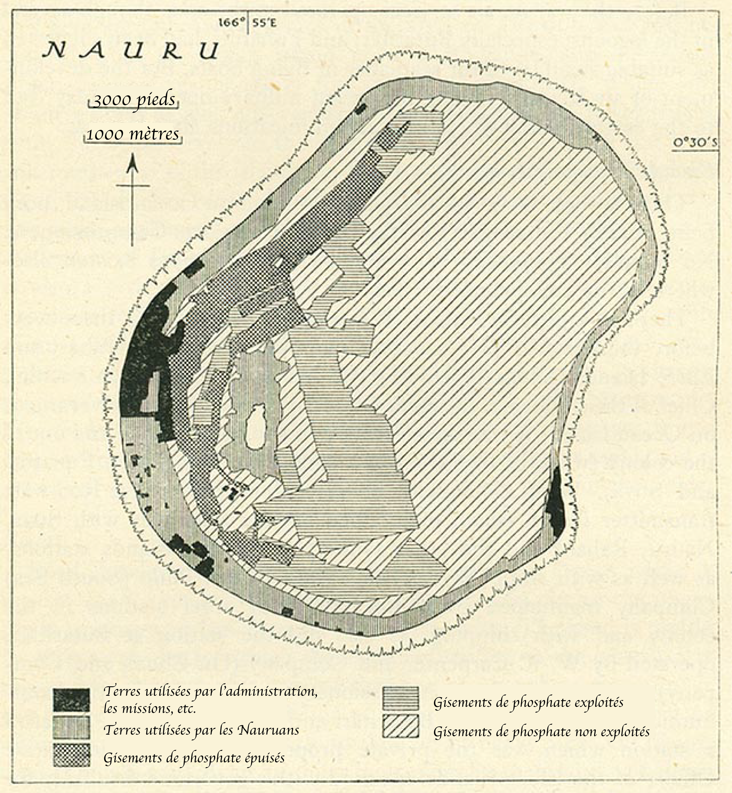
Nauru land utilization, 1940 |
||
| Source | http://www.lib.utexas.edu/maps/historical/pacific_islands_1943_1945/nauru_land_utilization.jpg | ||
| Author | translated in french by Kimdime69 | ||
| Permission (Reusing this file) |
|

|
This map image could be re-created using vector graphics as an SVG file. This has several advantages; see Commons:Media for cleanup for more information. If an SVG form of this image is available, please upload it and afterwards replace this template with
{{vector version available|new image name}}.
It is recommended to name the SVG file “Nauru land utilization-fr.svg”—then the template Vector version available (or Vva) does not need the new image name parameter. |
File history
Click on a date/time to view the file as it appeared at that time.
| Date/Time | Thumbnail | Dimensions | User | Comment | |
|---|---|---|---|---|---|
| current | 16:58, 19 January 2007 | | 2,343 × 2,540 (2.41 MB) | Kimdime (talk | contribs) | Uploaded from Perrt Castaneda collection http://www.lib.utexas.edu/maps/historical/pacific_islands_1943_1945/nauru_land_utilization.jpg and translated in french by {{u|Kimdime69}} {{PD-PCL}} |
You cannot overwrite this file.
File usage on Commons
The following page uses this file:
File usage on other wikis
The following other wikis use this file:
- Usage on azb.wikipedia.org
- Usage on en.wikipedia.org
- Usage on es.wikipedia.org
- Usage on fi.wikipedia.org
- Usage on fr.wikipedia.org
- Usage on lt.wikipedia.org
- Usage on ru.wikipedia.org
- Usage on uk.wikipedia.org