File:Nahkealehtinen kasvillisuus.png
Jump to navigation
Jump to search

Size of this preview: 800 × 398 pixels. Other resolutions: 320 × 159 pixels | 640 × 318 pixels | 1,262 × 628 pixels.
Original file (1,262 × 628 pixels, file size: 35 KB, MIME type: image/png)
Captions
Captions
Add a one-line explanation of what this file represents

|
Permission is granted to copy, distribute and/or modify this document under the terms of the GNU Free Documentation License, Version 1.2 or any later version published by the Free Software Foundation; with no Invariant Sections, no Front-Cover Texts, and no Back-Cover Texts. A copy of the license is included in the section entitled GNU Free Documentation License. |
| This file is licensed under the Creative Commons Attribution-Share Alike 3.0 Unported license. | ||
| Attribution: Vzb83 | ||
| ||
| This licensing tag was added to this file as part of the GFDL licensing update. |
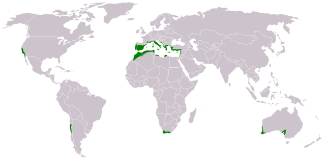
- Suomi: Nahkealehtisen eli välimerenkasvillisuuden levinneisyys.
- English: Distribution of Mediterranean forests, woodlands, and shrub biome.
Based on the blank world map BlankMap-World.png.
See also Image:Medclim.png and Image:Macchia mediterranea map.jpg.
File history
Click on a date/time to view the file as it appeared at that time.
| Date/Time | Thumbnail | Dimensions | User | Comment | |
|---|---|---|---|---|---|
| current | 15:34, 17 March 2018 | | 1,262 × 628 (35 KB) | Maphobbyist (talk | contribs) | Montenegro border |
| 02:15, 9 July 2011 |  | 1,262 × 628 (44 KB) | Maphobbyist (talk | contribs) | South Sudan has become independent on July 9, 2011. Sudan and South Sudan are shown with the new international border between them. | |
| 16:48, 11 June 2010 |  | 1,262 × 628 (44 KB) | Maphobbyist (talk | contribs) | Little editing | |
| 14:35, 11 June 2010 |  | 1,262 × 628 (44 KB) | Maphobbyist (talk | contribs) | Syria except the Mediterranean coastal area, Jordan, South Israel, Iraq, the Black Sea coast of Turkey and the Caspian Coast of Iran do not have a Mediterranean climate. The northwest coast of Libya including Tripoli,has a Mediterranean climate. | |
| 21:43, 13 February 2007 |  | 1,262 × 628 (14 KB) | Hautala (talk | contribs) | {{GFDL-user-fi|Vzb83}} * {{fi|Nahkealehtisen eli välimerenkasvillisuuden levinneisyys.}} * {{en|Distribution of Mediterranean forests, woodlands, and shrub biome.}} Based on the blank world map Image:BlankMap-World.png. See also [[:Image:Medclim |
You cannot overwrite this file.
File usage on Commons
There are no pages that use this file.
File usage on other wikis
The following other wikis use this file:
- Usage on an.wikipedia.org
- Usage on ar.wikipedia.org
- Usage on bs.wikipedia.org
- Usage on ca.wikipedia.org
- Usage on cs.wikipedia.org
- Usage on da.wikipedia.org
- Usage on eo.wikipedia.org
- Usage on eu.wikipedia.org
- Usage on fi.wikipedia.org
- Usage on hr.wikipedia.org
- Usage on ka.wikipedia.org
- Usage on no.wikipedia.org
- Usage on pt.wikipedia.org
- Usage on sh.wikipedia.org
- Usage on sr.wikipedia.org
- Usage on zh.wikipedia.org