File:NRC-regions-map.gif
Jump to navigation
Jump to search
No higher resolution available.
NRC-regions-map.gif (550 × 415 pixels, file size: 43 KB, MIME type: image/gif)
Captions
Captions
Add a one-line explanation of what this file represents
Summary[edit]
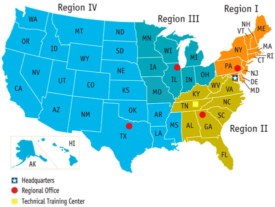
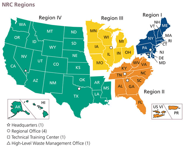
| Description | Map of the United States by Nuclear Regulatory Commission (NRC) Region (Now shows Mississippi in Region 4, rather than 2.) |
| Date | Last revised prior to July 21, 2008 (previous: February 17, 2007) |
| Source | http://www.nrc.gov/images/info-finder/region-state/regions-map.gif |
| Author | Nuclear Regulatory Commission |
| Permission (Reusing this file) |
"Information generated by the NRC or developed under an NRC contract is not copyrighted, unless indicated otherwise. Non-copyrighted material can be reproduced without permission; citation of the NRC as the source of the information is appreciated." |
Licensing[edit]
| This image is a work of a Nuclear Regulatory Commission employee, taken or made as part of that person's official duties. As a work of the U.S. federal government, the image is in the public domain in the United States. |
File history
Click on a date/time to view the file as it appeared at that time.
| Date/Time | Thumbnail | Dimensions | User | Comment | |
|---|---|---|---|---|---|
| current | 17:49, 21 July 2008 | | 550 × 415 (43 KB) | Wwoods (talk | contribs) | |
| 18:22, 12 January 2007 |  | 560 × 350 (23 KB) | BigrTex (talk | contribs) | {{Information |Description=Map of the United States by Nuclear Regulatory Commission (NRC) Region |Source=http://www.nrc.gov/images/info-finder/region-state/regions-map.gif |Date=Last revised Tuesday, September 20, 2005 |Author=Nuclear Regulatory Commissi |
You cannot overwrite this file.
File usage on Commons
The following page uses this file:
File usage on other wikis
The following other wikis use this file:
- Usage on de.wikipedia.org
- Usage on en.wikipedia.org
- Usage on en.wikibooks.org
- Usage on fr.wikipedia.org
- Usage on ja.wikipedia.org
- Usage on ko.wikipedia.org
- Usage on pl.wikipedia.org
- Usage on zh.wikipedia.org