File:NEFA 1961.svg
Jump to navigation
Jump to search

Size of this PNG preview of this SVG file: 763 × 599 pixels. Other resolutions: 306 × 240 pixels | 611 × 480 pixels | 978 × 768 pixels | 1,280 × 1,005 pixels | 2,560 × 2,011 pixels | 862 × 677 pixels.
Original file (SVG file, nominally 862 × 677 pixels, file size: 759 KB)
Captions
Captions
Add a one-line explanation of what this file represents
Summary[edit]
| Description |
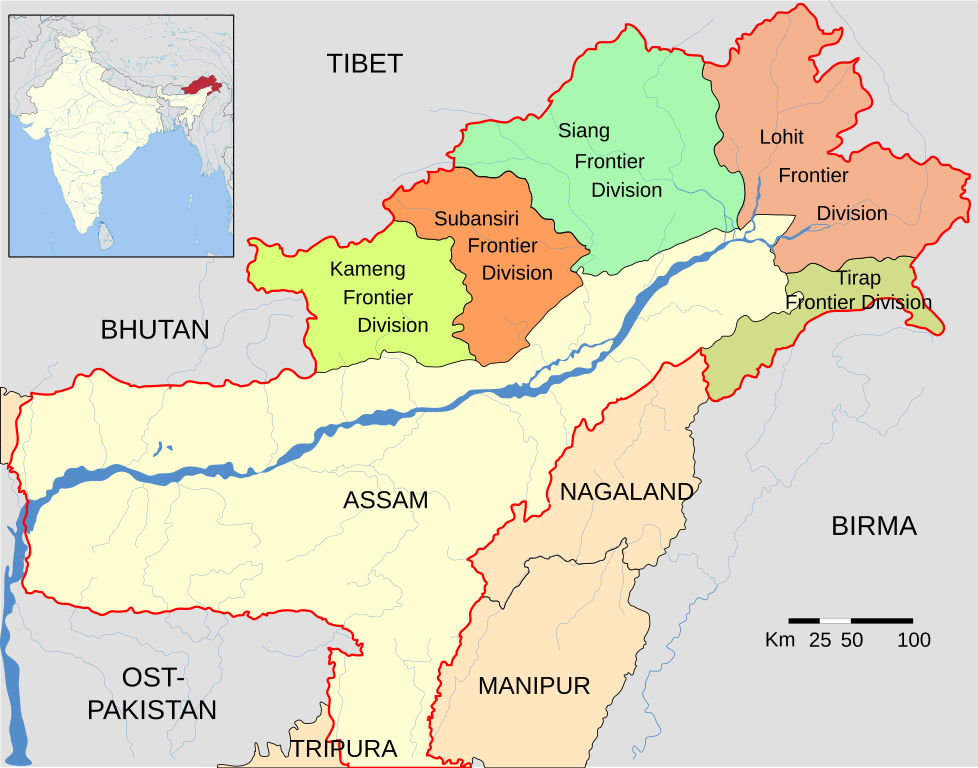
Deutsch: Das Gebiet der North East Frontier Agency (NEFA) 1961 kurz vor dem Indisch-chinesischen Grenzkrieg 1962.
Grenze Assams English: Territory of the North East Frontier Agency (NEFA), 1961, shortly before the Indo-Chinese War of 1962.
Border of Assam |
|||
| Date | ||||
| Source |
This vector image includes elements that have been taken or adapted from this file: This vector image includes elements that have been taken or adapted from this file: |
|||
| Author | Furfur | |||
| Permission (Reusing this file) |
I, the copyright holder of this work, hereby publish it under the following licenses:
This file is licensed under the Creative Commons Attribution-Share Alike 4.0 International license.
You may select the license of your choice. |
|||
| Other versions |
|
|||
| SVG development | This vector image was created with Adobe Illustrator. |


File history
Click on a date/time to view the file as it appeared at that time.
| Date/Time | Thumbnail | Dimensions | User | Comment | |
|---|---|---|---|---|---|
| current | 09:58, 9 October 2016 | | 862 × 677 (759 KB) | Furfur (talk | contribs) | Grenze Assams rot eingezeichnet |
| 21:06, 8 October 2016 |  | 862 × 677 (738 KB) | Furfur (talk | contribs) | Westbengalen war verloren gegangen | |
| 20:13, 8 October 2016 |  | 862 × 677 (738 KB) | Furfur (talk | contribs) | +Nagaland (Union Territory since 1957) | |
| 16:58, 8 October 2016 |  | 862 × 677 (727 KB) | Furfur (talk | contribs) | a typo | |
| 16:51, 8 October 2016 |  | 862 × 677 (727 KB) | Furfur (talk | contribs) | == {{int:filedesc}} == {{Information |Description={{User:Medium69/Traduction}} {{de|1=Das Gebiet der ''North East Frontier Agency'' (NEFA) 1961 kurz vor dem Indisch-chinesischen Grenzkrieg 1962.}} {{en|1=Territory of the ''North East Frontier Agency''... |
You cannot overwrite this file.
File usage on Commons
The following 3 pages use this file:
File usage on other wikis
The following other wikis use this file:
- Usage on de.wikipedia.org
- Usage on lv.wikipedia.org
- Usage on www.wikidata.org