File:NDH-Croacia1941-1945.svg
Jump to navigation
Jump to search

Size of this PNG preview of this SVG file: 796 × 600 pixels. Other resolutions: 319 × 240 pixels | 637 × 480 pixels | 1,019 × 768 pixels | 1,280 × 965 pixels | 2,560 × 1,929 pixels | 2,647 × 1,995 pixels.
Original file (SVG file, nominally 2,647 × 1,995 pixels, file size: 217 KB)
Captions
Captions
Add a one-line explanation of what this file represents
| Description |
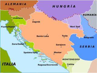
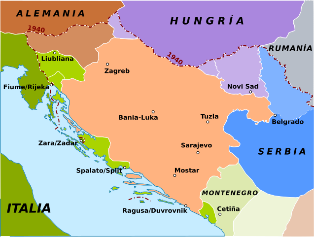
English: Map of Independent Croatia State in 1941 (red area). In green there are the Italian areas, and in brown the Hungarian areas and in blue the German areas.
Español: Reparto del norte de Yugoslavia por las potencias del Eje durante la Segunda Guerra Mundial y el Estado Independiente Croata (NDH):
Estado Independiente Croata (NDH)
Anexado a Alemania
Anexado a Italia
Montenegro (ocupado por Italia)
Territorios anexado a Albania (protectorado italiano)
Anexionado a Hungría
Serbia (ocupada militarmente por Alemania)
Banato (teóricamente serbio pero administrado por la minoría alemana de la región) |
| Date | (UTC) |
| Source | |
| Author |
|
| This is a retouched picture, which means that it has been digitally altered from its original version. Modifications: Spanish version and map turned into svg. The original can be viewed here: Croatia 41 45.gif:
|
I, the copyright holder of this work, hereby publish it under the following license:
| |
This work has been released into the public domain by its author, Example, at the [[::|English Wikipedia]] project. This applies worldwide. In case this is not legally possible: |
Original upload log[edit]
This image is a derivative work of the following images:
- File:Croatia_41_45.gif licensed with PD-user-w
- 2006-03-29T17:37:55Z Red devil 666 588x447 (22620 Bytes) Map of Indipendent Croatia State in 1941 (red area). In green there are the [[Italia|Italian]] areas, and in brown the [[Hungary|Hungarian]] areas and in blu the [[Germany|Germanian]] areas. Author: [[w:it:utente:Bukkia|Bucc
Uploaded with derivativeFX
File history
Click on a date/time to view the file as it appeared at that time.
| Date/Time | Thumbnail | Dimensions | User | Comment | |
|---|---|---|---|---|---|
| current | 09:06, 8 March 2018 | | 2,647 × 1,995 (217 KB) | Rowanwindwhistler (talk | contribs) | Minor spelling changes, new colours, legend moved to file description, 1940 border added, larger map. |
| 07:54, 21 May 2010 |  | 868 × 450 (144 KB) | Rowanwindwhistler (talk | contribs) | Spotted mistakes corrected | |
| 21:37, 10 January 2010 |  | 868 × 450 (144 KB) | Rowanwindwhistler (talk | contribs) | {{Information |Description={{en|1= Map of Independent Croatia State in 1941 (red area). In green there are the Italian areas, and in brown the Hungarian areas and in blue the German areas.}} {{es|1=Reparto del norte de Y |
You cannot overwrite this file.
File usage on Commons
The following 5 pages use this file:
File usage on other wikis
The following other wikis use this file:
- Usage on ast.wikipedia.org
- Usage on ca.wikipedia.org
- Usage on el.wikipedia.org
- Usage on es.wikipedia.org
- Usage on gl.wikipedia.org
- Usage on pt.wikipedia.org
- Usage on tr.wikipedia.org