File:Montrealmetromap-ms.svg
Jump to navigation
Jump to search

Size of this PNG preview of this SVG file: 420 × 539 pixels. Other resolutions: 187 × 240 pixels | 374 × 480 pixels | 598 × 768 pixels | 798 × 1,024 pixels | 1,596 × 2,048 pixels.
Original file (SVG file, nominally 420 × 539 pixels, file size: 260 KB)
Captions
Captions
Add a one-line explanation of what this file represents
Summary[edit]
| Description |
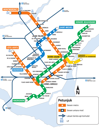
English: A map of the Montreal metro system. |
| Date | |
| Source |
Own work This vector image includes elements that have been taken or adapted from this file: |
| Author | Донор |
| Other versions |
|
| SVG development |

Licensing[edit]
This logo image consists only of simple geometric shapes or text. It does not meet the threshold of originality needed for copyright protection, and is therefore in the public domain. Although it is free of copyright restrictions, this image may still be subject to other restrictions. See WP:PD § Fonts and typefaces or Template talk:PD-textlogo for more information.
|
Non-simple shapes in the image (such as the island of Montreal) cannot be copyrighted as they are geographic formations.
File history
Click on a date/time to view the file as it appeared at that time.
| Date/Time | Thumbnail | Dimensions | User | Comment | |
|---|---|---|---|---|---|
| current | 21:29, 16 February 2017 | | 420 × 539 (260 KB) | Houdinipeter (talk | contribs) | Optimized SVG. |
| 15:21, 15 January 2017 |  | 420 × 539 (587 KB) | Донор (talk | contribs) | vector | |
| 15:04, 15 January 2017 |  | 420 × 539 (448 KB) | Донор (talk | contribs) | User created page with UploadWizard |
You cannot overwrite this file.
File usage on Commons
The following 11 pages use this file:
- User:Chumwa/OgreBot/Potential transport maps/2017 February 10-18
- User:Chumwa/OgreBot/Potential transport maps/2017 January 11-20
- User:Chumwa/OgreBot/Public transport information/2017 February 10-18
- User:Chumwa/OgreBot/Public transport information/2017 January 11-20
- User:Chumwa/OgreBot/Transport Maps/2017 February 10-18
- User:Chumwa/OgreBot/Transport Maps/2017 January 11-20
- User:Chumwa/OgreBot/Travel and communication maps/2017 February 10-18
- User:Chumwa/OgreBot/Travel and communication maps/2017 January 11-20
- User:Magog the Ogre/PD ineligible/2017 February 13-16
- Commons:Graphic Lab/Map workshop/Archive/2017
- File:Montrealmetromap.svg
File usage on other wikis
The following other wikis use this file:
- Usage on ms.wikipedia.org