File:Microwave tower in the Mojave National Preserve, California (28795031790).jpg
Jump to navigation
Jump to search
Size of this preview: 800 × 544 pixels. Other resolutions: 320 × 218 pixels | 640 × 435 pixels | 1,024 × 697 pixels | 1,280 × 871 pixels | 2,560 × 1,742 pixels | 4,990 × 3,395 pixels.
Original file (4,990 × 3,395 pixels, file size: 7.72 MB, MIME type: image/jpeg)
Captions
Captions
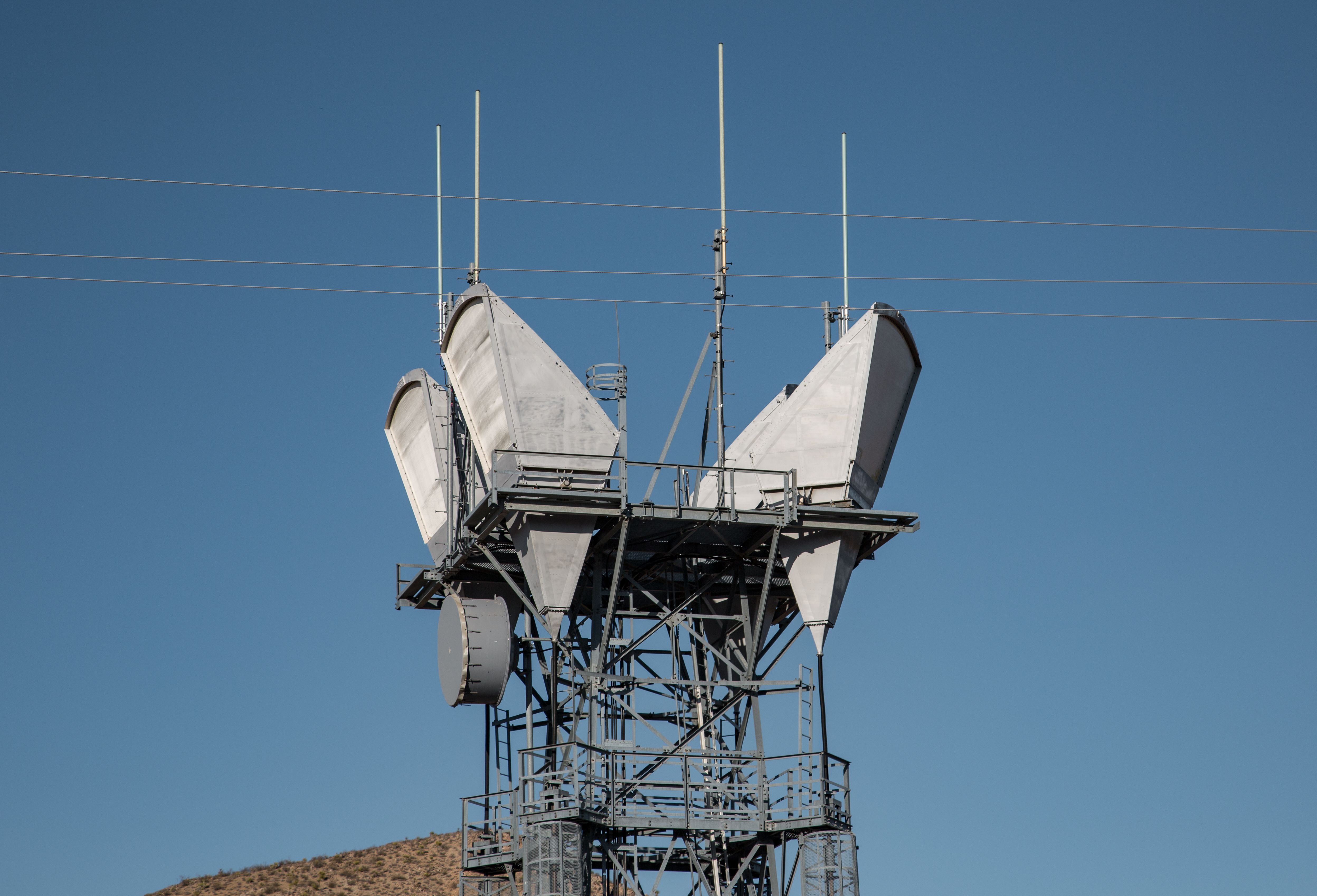
A giant tower that transmits data over extremely long distances.
Summary[edit]
.jpg&action=edit§ion=1)
| Description |
English: A microwave relay tower on Granite Pass, Mojave National Preserve, California. This is part of the TD-2 AT&T Long Lines system, a microwave relay network created by AT&T in the 1950s to relay telephone calls and other data between cities in the USA. The four angular cone-shaped antennas are called horn-reflector antennas, invented by Albert Beck and Harald Friis in 1941 and developed by D. L. Hogg at Bell Labs in 1961. They operate at C-band frequencies. at 4 and 6 GHz. They consist of a vertical flaring metal horn, fed by a vertical waveguide from the shed at ground level, with a reflector mounted in the mouth of the horn at a 45° angle, so the beam of microwaves is emitted horizontally. The reflector is a segment of a parabolic reflector, so the antenna is equivalent to a parabolic antenna fed off-axis. The advantage of this type of antenna over an ordinary parabolic (dish) antenna is that it radiates very little energy outside of the main beam. This allows the same microwave frequencies to be used by several nearby antennas pointing in different directions without interfering with each other. These KD-15676 antennas have a gain of about 43 dBi and produce a beamwidth (HPBW) of about 1° at 6 GHz. Two antennas are used for each path, one receiving and one transmitting. Each beam carried thousands of telephone calls. (From KD-15676 Horn Reflector Antenna Description, Bell System standards, AT&T |
| Date | |
| Source | Microwave tower in the Mojave National Preserve, California |
| Author | Tony Webster from Minneapolis, Minnesota |
| Camera location | | View this and other nearby images on: OpenStreetMap |
|---|
.jpg¶ms=034.811819_N_-115.609467_E_globe:Earth_type:camera_source:Flickr_&language=en)
Licensing[edit]
.jpg&action=edit§ion=2)
This file is licensed under the Creative Commons Attribution-Share Alike 2.0 Generic license.
- You are free:
- to share – to copy, distribute and transmit the work
- to remix – to adapt the work
- Under the following conditions:
- attribution – You must give appropriate credit, provide a link to the license, and indicate if changes were made. You may do so in any reasonable manner, but not in any way that suggests the licensor endorses you or your use.
- share alike – If you remix, transform, or build upon the material, you must distribute your contributions under the same or compatible license as the original.
| This image was originally posted to Flickr by Tony Webster at https://flickr.com/photos/87296837@N00/28795031790. It was reviewed on 6 January 2017 by FlickreviewR and was confirmed to be licensed under the terms of the cc-by-sa-2.0. |
File history
Click on a date/time to view the file as it appeared at that time.
| Date/Time | Thumbnail | Dimensions | User | Comment | |
|---|---|---|---|---|---|
| current | 00:38, 6 January 2017 | | 4,990 × 3,395 (7.72 MB) | Tony Webster (talk | contribs) | Transferred from Flickr via Flickr2Commons |
You cannot overwrite this file.
File usage on Commons
There are no pages that use this file.
File usage on other wikis
The following other wikis use this file:
- Usage on en.wikipedia.org
- Usage on tum.wikipedia.org
.jpg&oldid=643482490)