File:Meyers b6 s0890a.jpg
Jump to navigation
Jump to search

Size of this preview: 762 × 600 pixels. Other resolutions: 305 × 240 pixels | 610 × 480 pixels | 976 × 768 pixels | 1,280 × 1,008 pixels | 2,560 × 2,015 pixels | 3,191 × 2,512 pixels.
Original file (3,191 × 2,512 pixels, file size: 5.78 MB, MIME type: image/jpeg)
Captions
Captions
Add a one-line explanation of what this file represents
Summary[edit]
| Description |
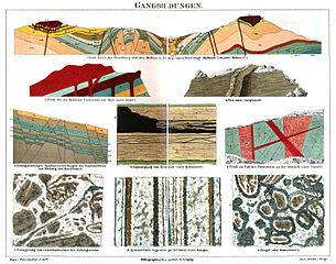
Deutsch: Original-Bildunterschrift: Gangbildungen. 1. Profil durch den Hirschberg und den Meißner in Hessen (nach Beyschlag). Maßstab 1 : 50,000. Höhen 2 : 1. 2. Profil von der Halbinsel Trotternish auf Skye (nach Zirkel). 3. Fels- oder Gangmauer. 4. Asphaltgang von Bentheim (nach Klockmann). 5. Gebirgsstörungen. Spaltenverwerfungen des Knottenflözes am Bleiberg bei Mechernich. 6. Profil am Fuß des Fürsteneck an der Gebruck (nach Gümbel). 7. Einlagerung von Gesteinsbrocken des Nebengesteins. 8. Symmetrisch lagenförmige Struktur eines Ganges. 9. Ringel- oder Kokardenerz. – Zum Artikel „Gang“ |
| Date | from 1885 until 1890 |
| Source | vol. 6 of the 4th edition of Meyers Konversations-Lexikon |
| Author | various |
| Other versions |
|

Licensing[edit]
This page comes from Book 6 of the 4th edition of Meyers Konversationslexikon (1885–90). The copyrights for that book have expired and this page is in the public domain.
|
This work is in the public domain in the United States because it was published (or registered with the U.S. Copyright Office) before January 1, 1929.
Public domain works must be out of copyright in both the United States and in the source country of the work in order to be hosted on the Commons. If the work is not a U.S. work, the file must have an additional copyright tag indicating the copyright status in the source country.
Note: This tag should not be used for sound recordings. |
File history
Click on a date/time to view the file as it appeared at that time.
| Date/Time | Thumbnail | Dimensions | User | Comment | |
|---|---|---|---|---|---|
| current | 01:53, 1 August 2015 | | 3,191 × 2,512 (5.78 MB) | Mapmarks (talk | contribs) | == {{int:filedesc}} == {{Information |description={{de|1=Original-Bildunterschrift: ''Gangbildungen. 1. Profil durch den Hirschberg und den Meißner in Hessen (nach Beyschlag). Maßstab {{nowrap|1 : 50,000.}} Höhen {{nowrap|2 : 1.}} 2. Profil von der... |
You cannot overwrite this file.
File usage on Commons
The following page uses this file:
File usage on other wikis
The following other wikis use this file:
- Usage on de.wikisource.org