File:Metro map of Brussels.svg
Jump to navigation
Jump to search

Size of this PNG preview of this SVG file: 795 × 600 pixels. Other resolutions: 318 × 240 pixels | 636 × 480 pixels | 1,018 × 768 pixels | 1,280 × 966 pixels | 2,560 × 1,932 pixels | 2,669 × 2,014 pixels.
Original file (SVG file, nominally 2,669 × 2,014 pixels, file size: 184 KB)
Captions
Captions
Add a one-line explanation of what this file represents
Summary[edit]
| Description |
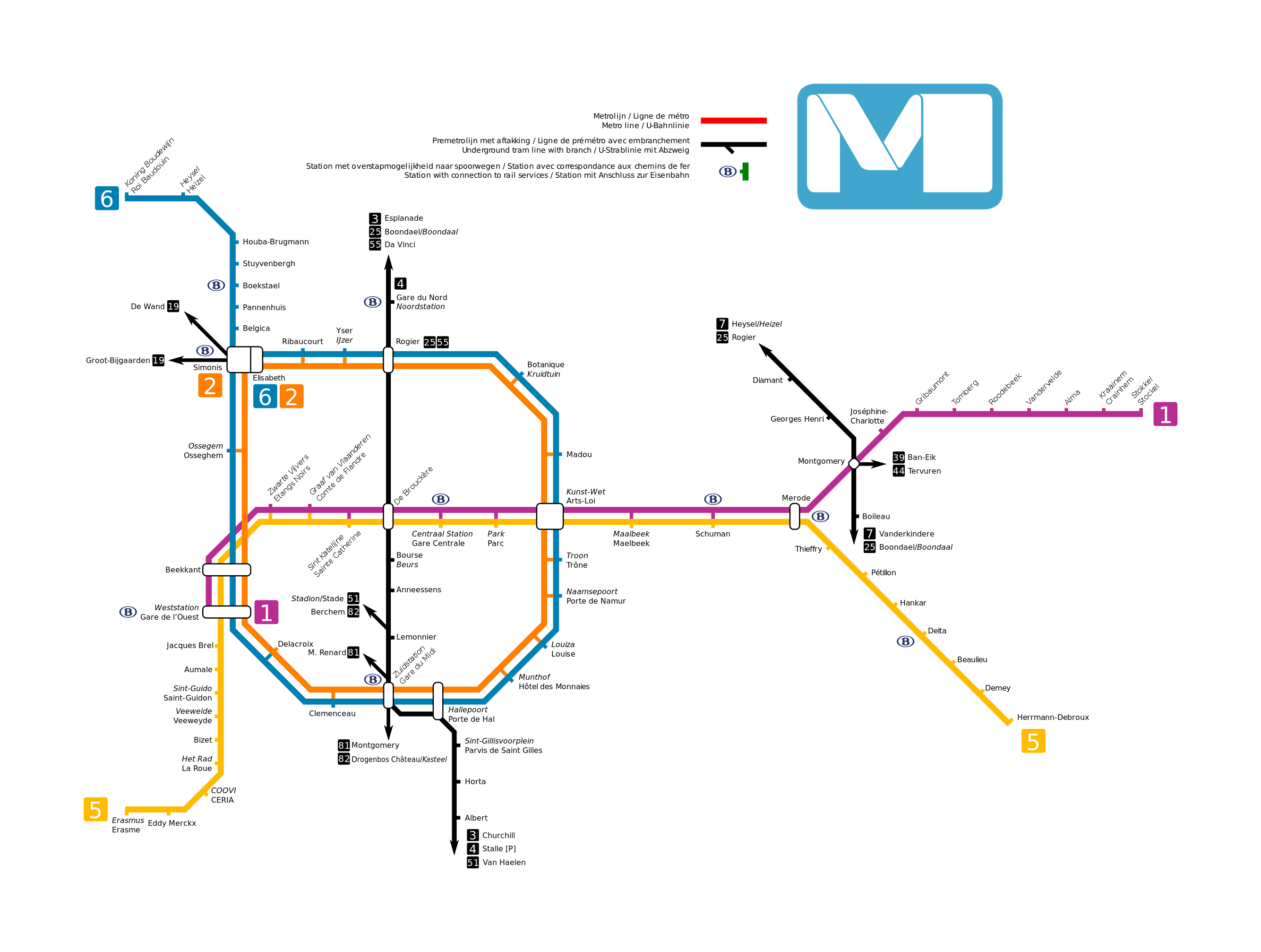
Deutsch: Schematische Karte der Brüsseler U- und Untergrundstraßenbahnlinien
Nederlands: Kaart van de Brusselse metro- en premetrolijnen
Français : Carte des lignes de métro et prémétro bruxelloises
English: Map of Brussels’ metro and underground tram services |
| Date | |
| Source | Own work |
| Author | Metrophil44 |
| Other versions | File:Metro map of Brussels.png |
Licensing[edit]
I, the copyright holder of this work, hereby publish it under the following license:
This file is licensed under the Creative Commons Attribution-Share Alike 4.0 International license.
- You are free:
- to share – to copy, distribute and transmit the work
- to remix – to adapt the work
- Under the following conditions:
- attribution – You must give appropriate credit, provide a link to the license, and indicate if changes were made. You may do so in any reasonable manner, but not in any way that suggests the licensor endorses you or your use.
- share alike – If you remix, transform, or build upon the material, you must distribute your contributions under the same or compatible license as the original.
File history
Click on a date/time to view the file as it appeared at that time.
| Date/Time | Thumbnail | Dimensions | User | Comment | |
|---|---|---|---|---|---|
| current | 17:48, 23 March 2016 | | 2,669 × 2,014 (184 KB) | Metrophil (talk | contribs) | bigger |
| 17:45, 23 March 2016 |  | 1,052 × 744 (181 KB) | Metrophil (talk | contribs) | User created page with UploadWizard |
You cannot overwrite this file.
File usage on Commons
The following 4 pages use this file: