File:Metro Paris M3-plan.svg
Jump to navigation
Jump to search

Size of this PNG preview of this SVG file: 800 × 291 pixels. Other resolutions: 320 × 117 pixels | 640 × 233 pixels | 1,024 × 373 pixels | 1,280 × 466 pixels | 2,560 × 932 pixels | 2,060 × 750 pixels.
Original file (SVG file, nominally 2,060 × 750 pixels, file size: 119 KB)
Captions
Captions
Add a one-line explanation of what this file represents
Summary[edit]
| Description |
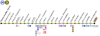
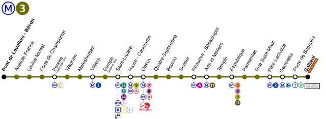
Français : Plan de la ligne de métro numéro 3 du métro de Paris |
| Date | |
| Source | Inspired by http://www.ratp.fr/informer/pdf/orienter/f_plan.php?nompdf=m3&loc=reseaux |
| Author | P.Poschadel |
Licensing[edit]
I, the copyright holder of this work, hereby publish it under the following licenses:

|
Permission is granted to copy, distribute and/or modify this document under the terms of the GNU Free Documentation License, Version 1.2 or any later version published by the Free Software Foundation; with no Invariant Sections, no Front-Cover Texts, and no Back-Cover Texts. A copy of the license is included in the section entitled GNU Free Documentation License. |
This file is licensed under the Creative Commons Attribution-Share Alike Attribution-Share Alike 4.0 International, 3.0 Unported, 2.5 Generic, 2.0 Generic and 1.0 Generic license.
- You are free:
- to share – to copy, distribute and transmit the work
- to remix – to adapt the work
- Under the following conditions:
- attribution – You must give appropriate credit, provide a link to the license, and indicate if changes were made. You may do so in any reasonable manner, but not in any way that suggests the licensor endorses you or your use.
- share alike – If you remix, transform, or build upon the material, you must distribute your contributions under the same or compatible license as the original.
You may select the license of your choice.
File history
Click on a date/time to view the file as it appeared at that time.
| Date/Time | Thumbnail | Dimensions | User | Comment | |
|---|---|---|---|---|---|
| current | 09:35, 25 August 2021 | 2,060 × 750 (119 KB) | AlexBurn44 (talk | contribs) | + RER E | |
| 01:03, 20 December 2019 | 2,060 × 750 (122 KB) | AlexBurn44 (talk | contribs) | ++ | ||
| 01:00, 20 December 2019 | 2,060 × 750 (123 KB) | AlexBurn44 (talk | contribs) | ++ | ||
| 16:46, 8 September 2019 | 2,060 × 750 (116 KB) | AlexBurn44 (talk | contribs) | + | ||
| 16:23, 26 September 2018 | 2,060 × 750 (115 KB) | AlexBurn44 (talk | contribs) | Logo Roissybus | ||
| 18:05, 6 April 2017 | 2,582 × 654 (142 KB) | The BurnPheonix (talk | contribs) | MODIFICATION LOGO GALLIENI | ||
| 11:23, 2 September 2016 | 1,920 × 486 (127 KB) | The BurnPheonix (talk | contribs) | Point de correspondance à Porte de Bagnolet | ||
| 12:17, 12 December 2012 | 2,582 × 654 (144 KB) | P.poschadel (talk | contribs) | Update - new connexion line T3b. | ||
| 20:58, 13 December 2008 | 2,582 × 654 (139 KB) | Hektor (talk | contribs) | |||
| 17:35, 15 November 2008 | 2,582 × 654 (114 KB) | M0tty (talk | contribs) | {{Information |Description= |Source= |Date= |Author= |Permission= |other_versions= }} |
You cannot overwrite this file.
File usage on Commons
The following 20 pages use this file:
- User:Chumwa/OgreBot/Potential transport maps/2016 September 1-10
- User:Chumwa/OgreBot/Potential transport maps/2017 April 1-10
- User:Chumwa/OgreBot/Potential transport maps/2018 September 21-30
- User:Chumwa/OgreBot/Potential transport maps/2019 December 11-20
- User:Chumwa/OgreBot/Potential transport maps/2019 September 1-10
- User:Chumwa/OgreBot/Public transport information/2016 September 1-10
- User:Chumwa/OgreBot/Public transport information/2018 September 21-30
- User:Chumwa/OgreBot/Public transport information/2019 December 11-20
- User:Chumwa/OgreBot/Public transport information/2019 September 1-10
- User:Chumwa/OgreBot/Public transport information/2021 August 21-31
- User:Chumwa/OgreBot/Transport Maps/2016 September 1-10
- User:Chumwa/OgreBot/Transport Maps/2017 April 1-10
- User:Chumwa/OgreBot/Transport Maps/2018 September 21-30
- User:Chumwa/OgreBot/Transport Maps/2019 December 11-20
- User:Chumwa/OgreBot/Transport Maps/2019 September 1-10
- User:Chumwa/OgreBot/Transport Maps/2021 August 21-31
- User:Chumwa/OgreBot/Travel and communication maps/2016 September 1-10
- User:Chumwa/OgreBot/Travel and communication maps/2017 April 1-10
- User:Chumwa/OgreBot/Travel and communication maps/2018 September 21-30
- User:Chumwa/OgreBot/Travel and communication maps/2019 September 1-10
File usage on other wikis
The following other wikis use this file:
- Usage on ar.wikipedia.org
- Usage on bs.wikipedia.org
- Usage on da.wikipedia.org
- Usage on de.wikipedia.org
- Usage on en.wikipedia.org
- Usage on eo.wikipedia.org
- Usage on es.wikipedia.org
- Usage on fr.wikipedia.org
- Usage on hu.wikipedia.org
- Usage on ru.wikipedia.org
- Usage on tr.wikipedia.org
- Usage on ug.wikipedia.org
- Usage on uk.wikipedia.org