File:Marianatrenchmap.png
Jump to navigation
Jump to search

Size of this preview: 460 × 599 pixels. Other resolutions: 184 × 240 pixels | 369 × 480 pixels | 756 × 984 pixels.
Original file (756 × 984 pixels, file size: 758 KB, MIME type: image/png)
Captions
Captions
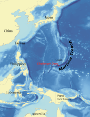
Map showing the Mariana Trench located southeast of Japan, east of Guam, and north of Papua New Guinea in the ocean territory of the Federated States of Mi
This is a picture of what it looks like from a satellite perspective.
Summary[edit]
| Description |
English: Map showing the location of the Mariana Trench, designed as a replacement for en:Image:Mariana_trench_location.jpg. Français : Carte montrant la position de la fosse des Mariannes.
Latina: Haec charta locum Fossae Marianae demonstrat. |
| Date | |
| Source | self-made using data from NOAA[dead link]. |
| Author | wallace |
Licensing[edit]
I, Kmusser, the copyright holder of this work, hereby publishes it under the following licenses:

|
Permission is granted to copy, distribute and/or modify this document under the terms of the GNU Free Documentation License, Version 1.2 or any later version published by the Free Software Foundation; with no Invariant Sections, no Front-Cover Texts, and no Back-Cover Texts. A copy of the license is included in the section entitled GNU Free Documentation License. |
| This file is licensed under the Creative Commons Attribution-Share Alike 3.0 Unported license. | ||
| Attribution: I, Kmusser | ||
| ||
| This licensing tag was added to this file as part of the GFDL licensing update. |
This file is licensed under the Creative Commons Attribution 2.5 Generic license.
Attribution: I, Kmusser
- You are free:
- to share – to copy, distribute and transmit the work
- to remix – to adapt the work
- Under the following conditions:
- attribution – You must give appropriate credit, provide a link to the license, and indicate if changes were made. You may do so in any reasonable manner, but not in any way that suggests the licensor endorses you or your use.
You may select the license of your choice.
File history
Click on a date/time to view the file as it appeared at that time.
| Date/Time | Thumbnail | Dimensions | User | Comment | |
|---|---|---|---|---|---|
| current | 21:39, 14 June 2020 | | 756 × 984 (758 KB) | Roy17 (talk | contribs) | lossless crop from 2007 original, then annotated |
| 08:43, 2 June 2016 |  | 756 × 985 (604 KB) | McGeddon (talk | contribs) | Cropped 1 % horizontally and < 1 % vertically using CropTool with precise mode. Crop out 1px black border. | |
| 06:09, 8 January 2008 |  | 761 × 989 (598 KB) | Lee Carre (talk | contribs) | File size efficiency, reduced my 50KB without loss of image data. | |
| 15:26, 2 August 2007 |  | 773 × 1,000 (658 KB) | Kmusser (talk | contribs) | {{Information |Description=Map showing the location of the Mariana Trench, designed as a replacement for en:Image:Mariana_trench_location.jpg. |Source=self-made using [http://www.ngdc.noaa.gov/seg/fliers/se-1104.shtml|data from |
You cannot overwrite this file.
File usage on Commons
The following 2 pages use this file:
File usage on other wikis
The following other wikis use this file:
- Usage on af.wikipedia.org
- Usage on ar.wikipedia.org
- Usage on ary.wikipedia.org
- Usage on ast.wikipedia.org
- Usage on azb.wikipedia.org
- Usage on az.wikipedia.org
- Usage on ba.wikipedia.org
- Usage on be-tarask.wikipedia.org
- Usage on be.wikipedia.org
- Usage on bg.wikipedia.org
- Usage on bn.wikipedia.org
- Usage on br.wikipedia.org
- Usage on bs.wikipedia.org
- Usage on ca.wikipedia.org
- Usage on ceb.wikipedia.org
- Usage on ce.wikipedia.org
- Usage on ckb.wikipedia.org
- Usage on cs.wikipedia.org
- Usage on da.wikipedia.org
- Usage on el.wikipedia.org
- Usage on en.wikipedia.org
- Challenger Deep
- Mariana Trench
- Abyssal plain
- Kaikō ROV
- User:Kmusser/Images
- Portal:Geology
- Nereus (underwater vehicle)
- Marianas Trench Marine National Monument
- Deep-sea community
- Wikipedia:ITN archives/2009/June
- User:DiverDave/Deep sea communities
- List of submarine topographical features
- User:سائغ/T
- Hadal zone microbial communities
- Usage on en.wikibooks.org
- Usage on en.wikinews.org
- Usage on eo.wikipedia.org
- Usage on es.wikipedia.org
View more global usage of this file.