File:Mapcarpat2.png
Jump to navigation
Jump to search
No higher resolution available.
Mapcarpat2.png (442 × 395 pixels, file size: 11 KB, MIME type: image/png)
Captions
Captions
Add a one-line explanation of what this file represents
Summary[edit]
| Description |
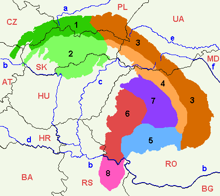
Dansk: Opdelingen af Karpaterne i sorte tal:
Ydre Vestkarpater
Indre Vestkarpater
Ydre Østkarpater
Indre Østkarpater
Sydkarpater eller Transsylvanske Alper
Rumænske Vestkarpater
Transsylvanske plateau
Serbiske Karpater
Floder i små blå bogstaver:
Lande (ISO 3166-1 alpha-2 codes), i røde kapitæler:
English: 1=Outer Western Carpathians, 2=Inner Western Carpathians, 3=Outer Eastern Carpathians, 4=Inner Eastern Carpathians, 5=Southern Carpathians or Transylvanian Alps, 6=Romanian Western Carpathians, 7=Transylvanian Plateau, 8=Serbian Carpathians. |
| Date | |
| Source | Own work |
| Author | :en:Markussep |
| Other versions | Mapcarpat.png |

|
Permission is granted to copy, distribute and/or modify this document under the terms of the GNU Free Documentation License, Version 1.2 or any later version published by the Free Software Foundation; with no Invariant Sections, no Front-Cover Texts, and no Back-Cover Texts. A copy of the license is included in the section entitled GNU Free Documentation License. |
| This file is licensed under the Creative Commons Attribution-Share Alike 3.0 Unported license. | ||
| ||
| This licensing tag was added to this file as part of the GFDL licensing update. |
File history
Click on a date/time to view the file as it appeared at that time.
| Date/Time | Thumbnail | Dimensions | User | Comment | |
|---|---|---|---|---|---|
| current | 17:58, 7 April 2021 | | 442 × 395 (11 KB) | Keyacom (talk | contribs) | Changes: BH -> BA, fixed font for MD |
| 17:56, 7 April 2021 |  | 442 × 395 (11 KB) | Keyacom (talk | contribs) | Reverted to version as of 17:45, 6 January 2019 (UTC) cuz forgot to specify the actual changes | |
| 17:52, 7 April 2021 |  | 442 × 395 (11 KB) | Keyacom (talk | contribs) | changes: | |
| 17:45, 6 January 2019 |  | 442 × 395 (11 KB) | Julieta39 (talk | contribs) | Add MD | |
| 00:10, 1 February 2014 |  | 442 × 395 (12 KB) | Olahus (talk | contribs) | Small changes on Austria, Romania and Serbia. | |
| 08:23, 24 May 2007 |  | 442 × 395 (12 KB) | Zeman (talk | contribs) | {{Information |Description= |Source=self-made |Date= |Author= User:Zeman }} | |
| 11:52, 12 July 2005 |  | 442 × 395 (9 KB) | Markussep (talk | contribs) | ISO 3166-1 alpha-2 country codes | |
| 11:32, 12 July 2005 |  | 442 × 395 (9 KB) | Markussep (talk | contribs) | Annotated version of image file Mapcarpat.png |
You cannot overwrite this file.
File usage on Commons
The following 3 pages use this file:
File usage on other wikis
The following other wikis use this file:
- Usage on als.wikipedia.org
- Usage on ar.wikipedia.org
- Usage on arz.wikipedia.org
- Usage on ast.wikipedia.org
- Usage on ba.wikipedia.org
- Usage on be-tarask.wikipedia.org
- Usage on be.wikipedia.org
- Usage on bg.wikipedia.org
- Usage on bn.wikipedia.org
- Usage on bs.wikipedia.org
- Usage on ca.wikipedia.org
- Usage on cs.wikipedia.org
- Usage on da.wikipedia.org
- Usage on de.wikipedia.org
- Usage on de.wiktionary.org
- Usage on el.wikipedia.org
- Usage on en.wikipedia.org
- Central Europe
- Carpathian Mountains
- Bucegi Mountains
- Outer Subcarpathia
- Southern Carpathians
- Apuseni Mountains
- Divisions of the Carpathians
- Talk:Divisions of the Carpathians
- Transylvanian Plateau
- Slovak Ore Mountains
- Retezat-Godeanu Mountains group
- Parâng Mountains group
- Făgăraș Mountains group
- Western Carpathians
- North Hungarian Mountains
- Northern Maramureș
- Talk:Northern Maramureș
- Eastern section of the Western Beskids
- Template:Inner North-Eastern Carpathians
View more global usage of this file.