File:Mapa del Caribe (límites marinos).png
Jump to navigation
Jump to search

Size of this preview: 800 × 530 pixels. Other resolutions: 320 × 212 pixels | 640 × 424 pixels | 1,024 × 679 pixels | 1,280 × 849 pixels | 2,514 × 1,667 pixels.
Original file (2,514 × 1,667 pixels, file size: 202 KB, MIME type: image/png)
Captions
Captions
Add a one-line explanation of what this file represents

|
File:Mapa del Caribe (límites marinos).svg is a vector version of this file. It should be used in place of this PNG file when not inferior.
File:Mapa del Caribe (límites marinos).png → File:Mapa del Caribe (límites marinos).svg
For more information, see Help:SVG. |
.svg) |
Summary[edit]
.png&action=edit§ion=1)
| Description |
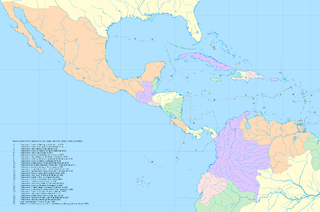
English: Map of maritime boundaries in the Caribbean Sea and Gulf of Mexico
Español: Mapa de los límites marinos en el Mar Caribe y el Golfo de México |
| Date | |
| Source |
|
| Author | Shadowxfox |
| Permission (Reusing this file) |
Distribuir y realizar archivos derivados |
Licensing[edit]
.png&action=edit§ion=2)
I, the copyright holder of this work, hereby publish it under the following license:
This file is licensed under the Creative Commons Attribution-Share Alike 3.0 Unported license.
- You are free:
- to share – to copy, distribute and transmit the work
- to remix – to adapt the work
- Under the following conditions:
- attribution – You must give appropriate credit, provide a link to the license, and indicate if changes were made. You may do so in any reasonable manner, but not in any way that suggests the licensor endorses you or your use.
- share alike – If you remix, transform, or build upon the material, you must distribute your contributions under the same or compatible license as the original.
File history
Click on a date/time to view the file as it appeared at that time.
| Date/Time | Thumbnail | Dimensions | User | Comment | |
|---|---|---|---|---|---|
| current | 20:16, 25 December 2008 | | 2,514 × 1,667 (202 KB) | Milenioscuro (talk | contribs) | {{Information |Description={{en|1=Map of maritime boundaries in the Caribbean Sea and Gulf of Mexico}} {{es|1=Mapa de los límites marinos en el Mar Caribe y el Golfo de México}} |Source=Own work |Author=Shadowxfox |Date=2008 |Permiss |
You cannot overwrite this file.
File usage on Commons
The following page uses this file:
File usage on other wikis
The following other wikis use this file:
- Usage on en.wikipedia.org
.png&oldid=803929827)