File:Mapa del Alto Vinalopó.svg
Jump to navigation
Jump to search

Size of this PNG preview of this SVG file: 595 × 595 pixels. Other resolutions: 240 × 240 pixels | 480 × 480 pixels | 768 × 768 pixels | 1,024 × 1,024 pixels | 2,048 × 2,048 pixels.
Original file (SVG file, nominally 595 × 595 pixels, file size: 229 KB)
Captions
Captions
Add a one-line explanation of what this file represents

|
This file has been superseded by Mapa de l'Alt Vinalopó.svg. It is recommended to use the other file. Please note that deleting superseded images requires consent. Reason to use the other file: "Better SVG version available, with translatable text tags instead of rendering them as bizarre vectors."
|

|
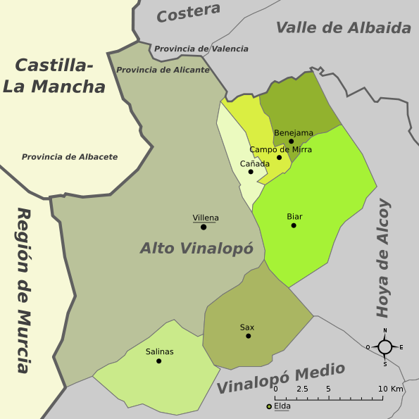
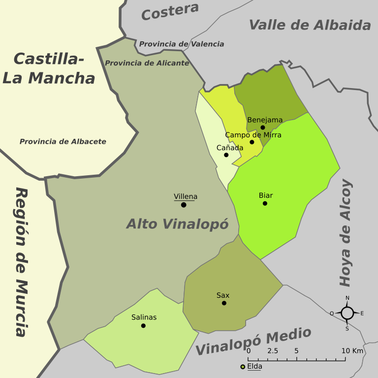
| Description | Mapa de la comarca del Alto Vinalopó (provincia de Alicante, España) |
| Date | Original: december 2004. Vectorization: february 2008 |
| Source | Image:Mapa de l'Alt Vinalopó.png, Image:Alicante - Mapa municipal.svg |
| Author | Original: Montxo Vicente i Sempere, uploaded by Martorell, vectorized by Rodriguillo |
| Permission (Reusing this file) |
This file is licensed under the Creative Commons Attribution-Share Alike 2.0 Generic license.
|
| SVG development |
File history
Click on a date/time to view the file as it appeared at that time.
| Date/Time | Thumbnail | Dimensions | User | Comment | |
|---|---|---|---|---|---|
| current | 23:05, 6 February 2008 | | 595 × 595 (229 KB) | Ignacio Icke (talk | contribs) | |
| 23:04, 6 February 2008 |  | 595 × 595 (230 KB) | Ignacio Icke (talk | contribs) | borders | |
| 18:00, 6 February 2008 |  | 595 × 595 (52 KB) | Rodriguillo (talk | contribs) | {{Information |Description= |Source= |Date= |Author= |Permission= |other_versions= }} | |
| 17:58, 6 February 2008 |  | 595 × 595 (52 KB) | Rodriguillo (talk | contribs) | {{Information |Description= |Source= |Date= |Author= |Permission= |other_versions= }} | |
| 17:54, 6 February 2008 |  | 595 × 595 (52 KB) | Rodriguillo (talk | contribs) | {{Information |Description= Mapa de la comarca del '''Alto Vinalopó''' (provincia de Alicante, España) |Source=Image:Mapa de l'Alt Vinalopó.png, Image:Alicante - Mapa municipal.svg |Date=Original: december 2004. Vectorization: february 2008 |
You cannot overwrite this file.
File usage on Commons
There are no pages that use this file.