File:Map of the United States with flags.svg
Jump to navigation
Jump to search

Size of this PNG preview of this SVG file: 800 × 505 pixels. Other resolutions: 320 × 202 pixels | 640 × 404 pixels | 1,024 × 647 pixels | 1,280 × 808 pixels | 2,560 × 1,617 pixels.
Original file (SVG file, nominally 950 × 600 pixels, file size: 6.56 MB)
Captions
Captions
Add a one-line explanation of what this file represents
Summary[edit]
| Description |
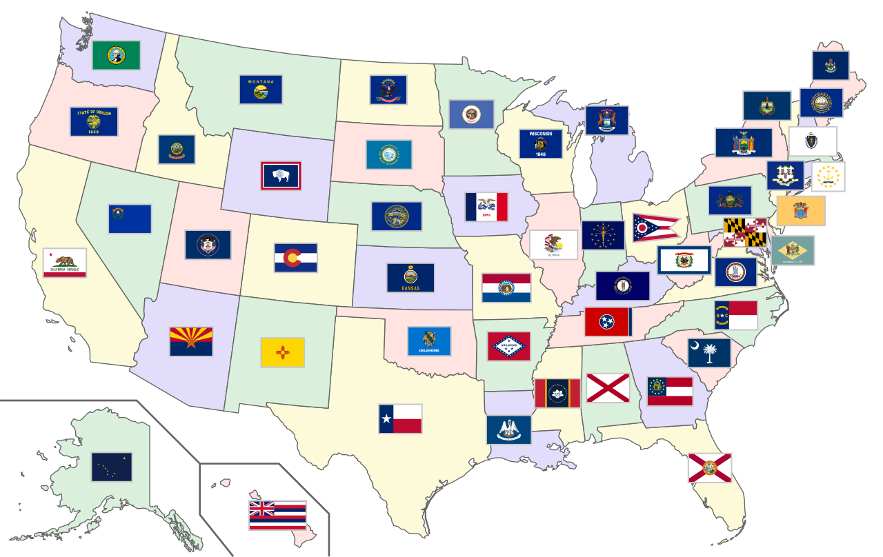
English: Map of the United States showing the state flags from 2021-01-11 until 2024-03-09. |
| Date | |
| Source | Own work based on: Blank US Map.svg and SVG flags of states of the United States |
| Author | SiBr4 and respective authors of base files |
| SVG development |
Licensing[edit]
I, the copyright holder of this work, hereby publish it under the following license:
This file is licensed under the Creative Commons Attribution-Share Alike 3.0 Unported license.
- You are free:
- to share – to copy, distribute and transmit the work
- to remix – to adapt the work
- Under the following conditions:
- attribution – You must give appropriate credit, provide a link to the license, and indicate if changes were made. You may do so in any reasonable manner, but not in any way that suggests the licensor endorses you or your use.
- share alike – If you remix, transform, or build upon the material, you must distribute your contributions under the same or compatible license as the original.
File history
Click on a date/time to view the file as it appeared at that time.
| Date/Time | Thumbnail | Dimensions | User | Comment | |
|---|---|---|---|---|---|
| current | 21:26, 14 March 2021 | | 950 × 600 (6.56 MB) | Mrmw (talk | contribs) | entire refresh (map + flags) |
| 07:42, 13 March 2021 |  | 950 × 600 (8.76 MB) | Luveha (talk | contribs) | Changed Mississippi's flag to the 2021 "In God We Trust" flag | |
| 11:57, 16 September 2015 |  | 950 × 600 (8.59 MB) | SiBr4 (talk | contribs) | Fixing the map borders | |
| 11:55, 16 September 2015 |  | 950 × 600 (8.59 MB) | SiBr4 (talk | contribs) | Trying to fix problems with CSS map coloring | |
| 11:51, 16 September 2015 |  | 950 × 600 (8.59 MB) | SiBr4 (talk | contribs) | {{Information |Description ={{en|1=Map of the United States showing the state flags.}} |Source =Own work; based on File:Blank US Map.svg and files in [[:Category:SVG flags of states of the United States]... |
You cannot overwrite this file.
File usage on Commons
The following page uses this file:
File usage on other wikis
The following other wikis use this file:
- Usage on bg.wikipedia.org
- Usage on ckb.wikipedia.org
- Usage on en.wikipedia.org
- Usage on glk.wikipedia.org
- Usage on hu.wikipedia.org
- Usage on mk.wikipedia.org
- Usage on mn.wikipedia.org
- Usage on nl.wikipedia.org
- Usage on pt.wikipedia.org
- Usage on simple.wikipedia.org
- Usage on sv.wikipedia.org
- Usage on zh-min-nan.wikipedia.org