File:Map of the Timișoara tramway and trolleybus routes.png
Jump to navigation
Jump to search

Size of this preview: 724 × 600 pixels. Other resolutions: 290 × 240 pixels | 580 × 480 pixels | 927 × 768 pixels | 1,237 × 1,024 pixels | 2,473 × 2,048 pixels | 3,108 × 2,574 pixels.
Original file (3,108 × 2,574 pixels, file size: 3.91 MB, MIME type: image/png)
Captions
Captions
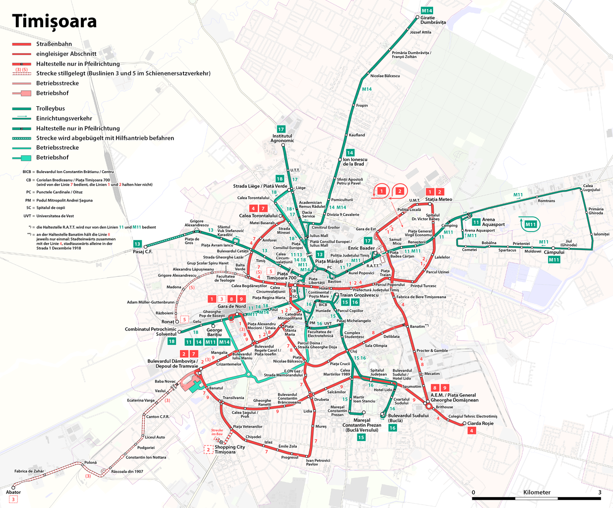
Timişoara tramlines and trolleybus
| Description |
|
|||
| Date | see file history | |||
| Source | Own work, using OpenStreetMap data for the background | |||
| Author | Maximilian Dörrbecker (Chumwa) | |||
| Permission (Reusing this file) |
All OpenStreetMap data and maps are Creative Commons "CC-BY-SA 2.0" licensed This file is licensed under the Creative Commons Attribution-Share Alike 2.0 Generic license.
|
|||
| Other versions |
Deutsch: In der deutschsprachigen Wikipedia existieren eine Reihe weiterer Pläne vom Nahverkehr in Timișoara:
English: In the German Wikipedia there are some more maps about the public transport in Timișoara:
|


File history
Click on a date/time to view the file as it appeared at that time.
| Date/Time | Thumbnail | Dimensions | User | Comment | |
|---|---|---|---|---|---|
| current | 18:44, 18 February 2018 | | 3,108 × 2,574 (3.91 MB) | Chumwa (talk | contribs) | kleinere Korrekturen und Ergänzungen |
| 20:56, 8 February 2018 |  | 3,108 × 2,574 (3.89 MB) | Chumwa (talk | contribs) | Aktualisierung | |
| 07:47, 23 September 2017 |  | 3,108 × 2,574 (3.88 MB) | Chumwa (talk | contribs) | Aktualisierung und kleinere Korrekturen | |
| 06:00, 15 September 2017 |  | 3,108 × 2,574 (3.88 MB) | Chumwa (talk | contribs) | Aktualisierung | |
| 19:37, 18 August 2016 |  | 3,108 × 2,574 (3.89 MB) | Chumwa (talk | contribs) | Wiederinbetriebnahme Linie 13, kleinere Korrekturen | |
| 05:29, 18 June 2016 |  | 3,108 × 2,574 (3.89 MB) | Chumwa (talk | contribs) | kleinere Korrektur | |
| 21:42, 26 January 2016 |  | 3,108 × 2,574 (3.88 MB) | Chumwa (talk | contribs) | neuer Hintergrund | |
| 21:27, 25 January 2016 |  | 3,108 × 2,574 (2.25 MB) | Chumwa (talk | contribs) | kleinere Korrekturen | |
| 21:03, 19 January 2016 |  | 3,108 × 2,574 (2.24 MB) | Chumwa (talk | contribs) | Ergänzungen | |
| 21:24, 18 January 2016 |  | 3,108 × 2,574 (2.24 MB) | Chumwa (talk | contribs) | Aktualisierung des Trolleybusnetzes |
You cannot overwrite this file.
File usage on Commons
The following 43 pages use this file:
- Transit maps
- User:Chumwa/Gallery
- User:Chumwa/OgreBot/Potential transport maps/2016 August 11-20
- User:Chumwa/OgreBot/Potential transport maps/2016 January 11-20
- User:Chumwa/OgreBot/Potential transport maps/2016 January 21-31
- User:Chumwa/OgreBot/Potential transport maps/2016 June 11-20
- User:Chumwa/OgreBot/Potential transport maps/2017 September 11-20
- User:Chumwa/OgreBot/Potential transport maps/2017 September 21-30
- User:Chumwa/OgreBot/Potential transport maps/2018 February 1-9
- User:Chumwa/OgreBot/Potential transport maps/2018 February 10-18
- User:Chumwa/OgreBot/Public transport information/2015 April 1-10
- User:Chumwa/OgreBot/Public transport information/2015 April 11-20
- User:Chumwa/OgreBot/Public transport information/2016 August 11-20
- User:Chumwa/OgreBot/Public transport information/2016 January 11-20
- User:Chumwa/OgreBot/Public transport information/2016 January 21-31
- User:Chumwa/OgreBot/Public transport information/2016 June 11-20
- User:Chumwa/OgreBot/Public transport information/2017 September 11-20
- User:Chumwa/OgreBot/Public transport information/2017 September 21-30
- User:Chumwa/OgreBot/Public transport information/2018 February 1-9
- User:Chumwa/OgreBot/Public transport information/2018 February 10-18
- User:Chumwa/OgreBot/Transport Maps/2015 April 1-10
- User:Chumwa/OgreBot/Transport Maps/2015 April 11-20
- User:Chumwa/OgreBot/Transport Maps/2016 August 11-20
- User:Chumwa/OgreBot/Transport Maps/2016 January 11-20
- User:Chumwa/OgreBot/Transport Maps/2016 January 21-31
- User:Chumwa/OgreBot/Transport Maps/2016 June 11-20
- User:Chumwa/OgreBot/Transport Maps/2017 September 11-20
- User:Chumwa/OgreBot/Transport Maps/2017 September 21-30
- User:Chumwa/OgreBot/Transport Maps/2018 February 1-9
- User:Chumwa/OgreBot/Transport Maps/2018 February 10-18
- User:Chumwa/OgreBot/Travel and communication maps/2016 August 11-20
- User:Chumwa/OgreBot/Travel and communication maps/2016 January 11-20
- User:Chumwa/OgreBot/Travel and communication maps/2016 January 21-31
- User:Chumwa/OgreBot/Travel and communication maps/2016 June 11-20
- User:Chumwa/OgreBot/Travel and communication maps/2017 September 11-20
- User:Chumwa/OgreBot/Travel and communication maps/2017 September 21-30
- User:Chumwa/OgreBot/Travel and communication maps/2018 February 1-9
- User:Chumwa/OgreBot/Travel and communication maps/2018 February 10-18
- File:Map of the Timişoara tramway and trolleybus routes.png (file redirect)
- File:Map of the Timișoara tramway and trolleybus routes.png
- File:Netzentwicklungsplan der Straßenbahn Timișoara.png
- File:Netzentwicklungsplan des Oberleitungsbus Timișoara.png
- Category:Trams in Timișoara
File usage on other wikis
The following other wikis use this file:
- Usage on de.wikipedia.org
- Timișoara
- Oberleitungsbus Timișoara
- Societatea de Transport Public Timișoara
- Straßenbahn Timișoara
- Datei:Temesvar 1909.JPG
- Wikipedia:Kartenwerkstatt/Archiv/2010-12
- Benutzer Diskussion:Chumwa/Archiv/2011/1. Quartal
- Benutzer Diskussion:Chumwa/Archiv/2011/2. Quartal
- Datei:Straßenbahnnetz Timișoara 1899.png
- Datei:Straßenbahnnetz Timișoara 1906.jpg
- Datei:Straßenbahnnetz Timișoara 1915.jpg
- Benutzer Diskussion:Chumwa/Archiv/2014/2. Quartal
- Wikipedia:Kartenwerkstatt/Karte des Tages/Galerie
- Benutzer Diskussion:Chumwa/Archiv/2015/1. Quartal
- Benutzer Diskussion:Chumwa/Archiv/2016/1. Quartal
- Benutzer Diskussion:Chumwa/Archiv/2018/1. Quartal
- Usage on de.wikivoyage.org
- Usage on en.wikivoyage.org
- Usage on fr.wikipedia.org
- Usage on he.wikivoyage.org
- Usage on it.wikipedia.org
- Usage on it.wikivoyage.org
- Usage on pl.wikipedia.org
- Usage on ro.wikipedia.org
- Usage on www.wikidata.org