File:Map of old churches in Scandinavia.jpg
Jump to navigation
Jump to search

Size of this preview: 604 × 600 pixels. Other resolutions: 242 × 240 pixels | 483 × 480 pixels | 773 × 768 pixels | 1,031 × 1,024 pixels | 1,417 × 1,407 pixels.
Original file (1,417 × 1,407 pixels, file size: 135 KB, MIME type: image/jpeg)
Captions
Captions
Add a one-line explanation of what this file represents
Summary
[edit]
| Description |
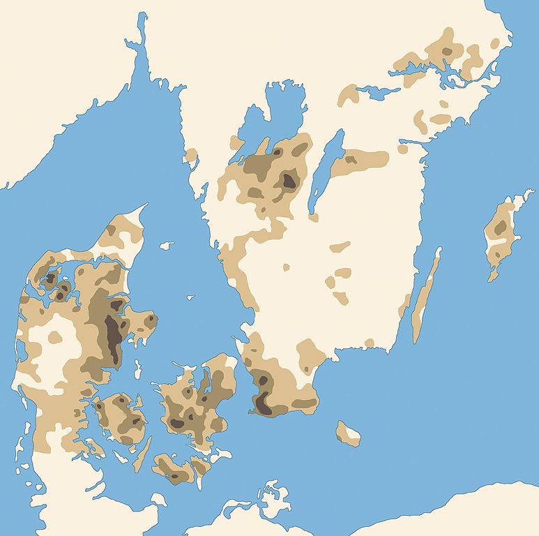
English: Map of possible early medieval churches (i.e. from Scandinavian viking age) in Denmark and southern Sweden. Calculations are based om parish churches outside cities, known from late medieval written sources (after 1200). Darkest color represents churches closer than 2,5 km from each other. Middle-color represents 2,5-5 km distance, and brightest color represents churches with 5-7,5 km distance from each other. (Archeological findings of christian burial from latest the year 1000 in Torsåker parish in Ångermanland county, and several stone-churches and parishes from 12th and 13th century, shows that early medieval churches also may have occured in central northern Sweden.) Svenska: Karta över möjliga tidigmedeltida kyrkor (dvs från Skandinavisk vikingatid) i Danmark och södra Sverige. Basen i beräkningarna är de sockenkyrkor utanför städerna som omtalas under senmedeltiden (dvs efter år 1200). Arkeologin har visat att merparten av dessa sten- eller tegelkyrkor ligger på samma plats sedan den äldsta kristna tiden. Mörkast färg anger kyrkor tätare än 2,5 km mellan varandra. Mellan-mörka färgen anger kyrkor mellan 2,5-5 km, och ljusaste färgtonen anger kyrkor med mellan 5-7,5 km avstånd mellan varandra. (Arkeologiska fynd av kristet gravskick från senast år 1000 i Torsåker socken i Ångermanland, och flera stenkyrkor och församlingar från 11- och 1200-talen, visar att tidigmedeltida kyrkor även kan ha förekommit i Mellannorrland.) |
| Source | Own work |
| Author | Sven Rosborn |
Licensing
[edit]
I, the copyright holder of this work, hereby publish it under the following licenses:

|
Permission is granted to copy, distribute and/or modify this document under the terms of the GNU Free Documentation License, Version 1.2 or any later version published by the Free Software Foundation; with no Invariant Sections, no Front-Cover Texts, and no Back-Cover Texts. A copy of the license is included in the section entitled GNU Free Documentation License. |
| This file is licensed under the Creative Commons Attribution-Share Alike 3.0 Unported license. | ||
| ||
| This licensing tag was added to this file as part of the GFDL licensing update. |
This file is licensed under the Creative Commons Attribution-Share Alike 2.5 Generic, 2.0 Generic and 1.0 Generic license.
- You are free:
- to share – to copy, distribute and transmit the work
- to remix – to adapt the work
- Under the following conditions:
- attribution – You must give appropriate credit, provide a link to the license, and indicate if changes were made. You may do so in any reasonable manner, but not in any way that suggests the licensor endorses you or your use.
- share alike – If you remix, transform, or build upon the material, you must distribute your contributions under the same or compatible license as the original.
You may select the license of your choice.
kyrkobyggnader tätare än 2,5 km, mellan 2,5-5 km, och 5-7,5 km
File history
Click on a date/time to view the file as it appeared at that time.
| Date/Time | Thumbnail | Dimensions | User | Comment | |
|---|---|---|---|---|---|
| current | 16:25, 1 December 2006 | | 1,417 × 1,407 (135 KB) | Sven Rosborn (talk | contribs) | {{Information |Description=Map of old medieaval churches in Sweden and Denmark. |Source=Own work. |Date=‘-’ |Author=Sven Rosborn |Permission=See below |other_versions=‘-’ }} |
You cannot overwrite this file.
File usage on Commons
The following page uses this file:
File usage on other wikis
The following other wikis use this file:
- Usage on de.wikipedia.org
- Usage on en.wikipedia.org
- Usage on et.wikipedia.org
- Usage on sv.wikipedia.org
- Usage on www.wikidata.org