File:Map of northeastern Alabama and northwestern Georgia showing movement of Union troops under the command of Gen. Edward M. McCook. LOC 2004626931.jpg
Jump to navigation
Jump to search

Size of this preview: 693 × 600 pixels. Other resolutions: 277 × 240 pixels | 555 × 480 pixels | 888 × 768 pixels | 1,184 × 1,024 pixels | 2,367 × 2,048 pixels | 5,111 × 4,422 pixels.
Original file (5,111 × 4,422 pixels, file size: 3.26 MB, MIME type: image/jpeg)
Captions
Captions
Add a one-line explanation of what this file represents
Summary[edit]
| Description |
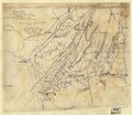
English: Relief shown by hachures. Title derived from Stephenson's Civil War maps, 1989. "Traced from La Tourrette's state map of Alabama, 1856." Pen-in-ink on tracing cloth. Mounted on paper. LC Civil War maps (2nd ed.), S15, 103 Available also through the Library of Congress web site as raster image. |
||
| Title | [Map of northeastern Alabama and northwestern Georgia showing movement of Union troops under the command of Gen. Edward M. McCook]. | ||
| Shelf ID | G3971.S5 1864 .M3 | ||
| Date | |||
| Source | https://www.loc.gov/item/2004626931/ | ||
| Author | Unknown author | ||
| Permission (Reusing this file) |
|
||
| Other versions |
|
||
| Location | United States · Alabama · Georgia | ||
| Part of | Military Battles And Campaigns · American Memory · Civil War Maps · Catalog · Geography And Map Division | ||
| Subject | Maps, Manuscript · (Edward Moody) · Georgia · Civil War · United States · Alabama · Mccook, Edward M. · History |

Licensing[edit]
|
This is a faithful photographic reproduction of a two-dimensional, public domain work of art. The work of art itself is in the public domain for the following reason:
The official position taken by the Wikimedia Foundation is that "faithful reproductions of two-dimensional public domain works of art are public domain".
This photographic reproduction is therefore also considered to be in the public domain in the United States. In other jurisdictions, re-use of this content may be restricted; see Reuse of PD-Art photographs for details. | ||||
File history
Click on a date/time to view the file as it appeared at that time.
| Date/Time | Thumbnail | Dimensions | User | Comment | |
|---|---|---|---|---|---|
| current | 06:28, 18 May 2018 | | 5,111 × 4,422 (3.26 MB) | Fæ (talk | contribs) | LOC Maps https://www.loc.gov/item/2004626931/ #10590 |
You cannot overwrite this file.
File usage on Commons
The following 3 pages use this file:
- File:(Map of northeastern Alabama and northwestern Georgia showing movement of Union troops under the command of Gen. Edward M. McCook). LOC 2004626931.jpg (file redirect)
- File:Map of northeastern Alabama and northwestern Georgia showing movement of Union troops under the command of Gen. Edward M. McCook. LOC 2004626931.tif
._LOC_2004626931.jpg&redirect=no)