File:Map of USA with state names mr.png
Jump to navigation
Jump to search
Size of this preview: 800 × 495 pixels. Other resolutions: 320 × 198 pixels | 640 × 396 pixels | 959 × 593 pixels.
Original file (959 × 593 pixels, file size: 125 KB, MIME type: image/png)
Captions
Captions
Add a one-line explanation of what this file represents
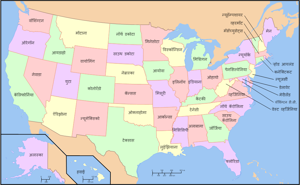
| Description | A compass of the United States, with state names. The original was edited by User:Andrew c to include Nova Scotia, PEI, Bahamas, and scale key. It was originally uploaded to the English Wikipedia with the same title by w:User:Wapcaplet: * 20:57, 9 October 2005 |
| Date | (UTC) |
| Source | |
| Author |
|
| This is a retouched picture, which means that it has been digitally altered from its original version. Modifications: State names translated in Marathi. The original can be viewed here: Map of USA with state names.svg:
|
I, the copyright holder of this work, hereby publish it under the following licenses:
This file is licensed under the Creative Commons Attribution-Share Alike 3.0 Unported, 2.5 Generic, 2.0 Generic and 1.0 Generic license.
- You are free:
- to share – to copy, distribute and transmit the work
- to remix – to adapt the work
- Under the following conditions:
- attribution – You must give appropriate credit, provide a link to the license, and indicate if changes were made. You may do so in any reasonable manner, but not in any way that suggests the licensor endorses you or your use.
- share alike – If you remix, transform, or build upon the material, you must distribute your contributions under the same or compatible license as the original.

|
Permission is granted to copy, distribute and/or modify this document under the terms of the GNU Free Documentation License, Version 1.2 or any later version published by the Free Software Foundation; with no Invariant Sections, no Front-Cover Texts, and no Back-Cover Texts. A copy of the license is included in the section entitled GNU Free Documentation License. |
You may select the license of your choice.
Original upload log[edit]
This image is a derivative work of the following images:
- Image:Map_of_USA_with_state_names.svg licensed with Cc-by-sa-3.0,2.5,2.0,1.0, Cc-by-sa-3.0,2.5,2.0,1.0, GFDL, GFDL/en
- 2007-06-11T13:23:48Z Andrew c 959x593 (339488 Bytes)
- 2007-04-17T06:15:06Z Andrew c 959x593 (336711 Bytes)
- 2005-12-28T18:36:54Z Dbenbenn 959x593 (317355 Bytes) fix error in
- 2005-10-09T22:14:30Z Dbenbenn 959x593 (339217 Bytes) fixed by [[User:Ed g2s]] (removed tag), and me (removed undisplayed shapes: rivers, lakes, capitals, highways. Cropped. Fixed typos.)
- 2005-10-09T22:12:53Z Dbenbenn 990x855 (978926 Bytes) original version from [[w:Image:Map of USA with state names.svg]] by [[w:User:Wapcaplet]], cc-by-2.0
Uploaded with derivativeFX
File history
Click on a date/time to view the file as it appeared at that time.
| Date/Time | Thumbnail | Dimensions | User | Comment | |
|---|---|---|---|---|---|
| current | 11:54, 16 December 2008 | | 959 × 593 (125 KB) | Abhijitsathe (talk | contribs) | {{Information |Description=A compass of the United States, with state names. The original was edited by User:Andrew c to include Nova Scotia, PEI, Bahamas, and scale key. It was originally uploaded to the English Wikipedia with the same title by |
You cannot overwrite this file.
File usage on Commons
There are no pages that use this file.