File:Map of Preston.png
Jump to navigation
Jump to search

Size of this preview: 800 × 565 pixels. Other resolutions: 320 × 226 pixels | 640 × 452 pixels | 883 × 624 pixels.
Original file (883 × 624 pixels, file size: 212 KB, MIME type: image/png)
Captions
Captions
Add a one-line explanation of what this file represents
Summary[edit]
| Description |
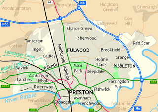
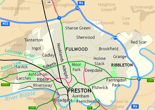
English: Places in the urban settlement of Preston, Lancashire, England.
|
| Date | |
| Source | Own work |
| Author | Dr Greg |
Licensing[edit]
| I, the copyright holder of this work, release this work into the public domain. This applies worldwide. In some countries this may not be legally possible; if so: I grant anyone the right to use this work for any purpose, without any conditions, unless such conditions are required by law. |
File history
Click on a date/time to view the file as it appeared at that time.
| Date/Time | Thumbnail | Dimensions | User | Comment | |
|---|---|---|---|---|---|
| current | 21:58, 13 September 2010 | | 883 × 624 (212 KB) | Dr Greg (talk | contribs) | more accurate version |
| 22:04, 22 August 2010 |  | 879 × 623 (205 KB) | Dr Greg (talk | contribs) | {{Information |Description={{en|1=Places in the urban settlement of en:Preston, Lancashire, England.}} |Source={{own}} |Author=Dr Greg |Date=2010-08-22 |Permission= |other_versions= }} Category:Maps of Lancashire [[Category:Pre |
You cannot overwrite this file.
File usage on Commons
The following 2 pages use this file:
File usage on other wikis
The following other wikis use this file:
- Usage on ar.wikipedia.org
- Usage on azb.wikipedia.org
- Usage on en.wikipedia.org
- Usage on es.wikipedia.org