File:Map of Pennsylvania highlighting Carbon County.svg
Jump to navigation
Jump to search

Size of this PNG preview of this SVG file: 800 × 460 pixels. Other resolutions: 320 × 184 pixels | 640 × 368 pixels | 1,024 × 589 pixels | 1,280 × 736 pixels | 2,560 × 1,472 pixels | 4,950 × 2,846 pixels.
Original file (SVG file, nominally 4,950 × 2,846 pixels, file size: 106 KB)
Captions
Captions
Add a one-line explanation of what this file represents
Summary[edit]
| Description |
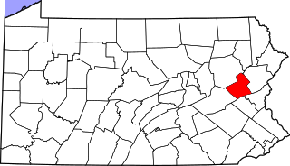
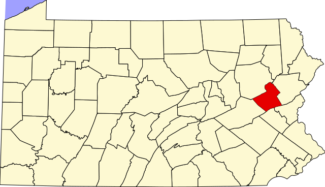
English: This is a locator map showing Carbon County in Pennsylvania. For more information, see Commons:United States county locator maps. |
| Date | |
| Source |
Own work: English: The maps use data from nationalatlas.gov, specifically countyp020.tar.gz on the Raw Data Download page. The maps also use state outline data from statesp020.tar.gz. The Florida maps use hydrogm020.tar.gz to display Lake Okeechobee. |
| Author | David Benbennick |
| SVG development |
Licensing[edit]
| I, the copyright holder of this work, release this work into the public domain. This applies worldwide. In some countries this may not be legally possible; if so: I grant anyone the right to use this work for any purpose, without any conditions, unless such conditions are required by law. |
File history
Click on a date/time to view the file as it appeared at that time.
| Date/Time | Thumbnail | Dimensions | User | Comment | |
|---|---|---|---|---|---|
| current | 16:20, 12 February 2006 | | 4,950 × 2,846 (106 KB) | David Benbennick (talk | contribs) | {{subst:User:Dbenbenn/clm|county=Carbon County|state=Pennsylvania|type=county}} |
You cannot overwrite this file.
File usage on Commons
The following 7 pages use this file:
- Category:Births in Carbon County, Pennsylvania
- Category:Bridges in Carbon County, Pennsylvania
- Category:Carbon County, Pennsylvania
- Category:Education in Carbon County, Pennsylvania
- Category:History of Carbon County, Pennsylvania
- Category:Maps of Carbon County, Pennsylvania
- Category:Populated places in Carbon County, Pennsylvania
File usage on other wikis
The following other wikis use this file:
- Usage on ar.wikipedia.org
- Usage on bg.wikipedia.org
- Usage on bpy.wikipedia.org
- Usage on cdo.wikipedia.org
- Usage on ceb.wikipedia.org
- Usage on cy.wikipedia.org
- Usage on de.wikipedia.org
- Usage on en.wikipedia.org
- List of counties in Pennsylvania
- Carbon County, Pennsylvania
- Banks Township, Carbon County, Pennsylvania
- Beaver Meadows, Pennsylvania
- Bowmanstown, Pennsylvania
- East Penn Township, Pennsylvania
- East Side, Pennsylvania
- Franklin Township, Carbon County, Pennsylvania
- Jim Thorpe, Pennsylvania
- Kidder Township, Pennsylvania
- Lansford, Pennsylvania
- Lausanne Township, Pennsylvania
- Lehigh Township, Carbon County, Pennsylvania
- Lehighton, Pennsylvania
- Lower Towamensing Township, Pennsylvania
- Mahoning Township, Carbon County, Pennsylvania
- Nesquehoning, Pennsylvania
- Packer Township, Pennsylvania
- Palmerton, Pennsylvania
- Parryville, Pennsylvania
- Penn Forest Township, Pennsylvania
- Summit Hill, Pennsylvania
- Towamensing Township, Pennsylvania
- Tresckow, Pennsylvania
- Weatherly, Pennsylvania
- Weissport, Pennsylvania
- Weissport East, Pennsylvania
- Template:Carbon County, Pennsylvania
- Lake Harmony, Pennsylvania
- User:Nyttend/County templates/PA/1
- National Register of Historic Places listings in Carbon County, Pennsylvania
- List of Pennsylvania state historical markers in Carbon County
- Category:Populated places in Carbon County, Pennsylvania
- Audenried, Pennsylvania
- Harrity, Pennsylvania
- Albrightsville, Pennsylvania
- Normal Square, Pennsylvania
- Little Gap, Pennsylvania
View more global usage of this file.