File:Map of Africa in 1939.png
Jump to navigation
Jump to search
No higher resolution available.
Map_of_Africa_in_1939.png (360 × 360 pixels, file size: 11 KB, MIME type: image/png)
Captions
Captions
Add a one-line explanation of what this file represents

|
File:Map of Africa in 1939.svg is a vector version of this file. It should be used in place of this PNG file when not inferior.
File:Map of Africa in 1939.png → File:Map of Africa in 1939.svg
For more information, see Help:SVG. |
 |
Summary[edit]
| Description |
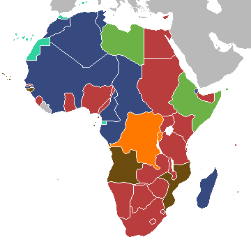
English: This is a map of Africa on the outbreak of the Second World War.
Colonies and protectorates:
|
| Date | |
| Source | Own work |
| Author | Brigade Piron |
| Other versions |
[]
|


.svg)

_ast.svg)


-es.svg)
_mapa.png)

_eu.svg)


.svg)

.jpg)


-sr.png)


.svg)

.svg)

Licensing[edit]
I, the copyright holder of this work, hereby publish it under the following license:
This file is licensed under the Creative Commons Attribution-Share Alike 3.0 Unported license.
- You are free:
- to share – to copy, distribute and transmit the work
- to remix – to adapt the work
- Under the following conditions:
- attribution – You must give appropriate credit, provide a link to the license, and indicate if changes were made. You may do so in any reasonable manner, but not in any way that suggests the licensor endorses you or your use.
- share alike – If you remix, transform, or build upon the material, you must distribute your contributions under the same or compatible license as the original.
Derivative work of File:BlankMap-Africa-1935.png
File history
Click on a date/time to view the file as it appeared at that time.
| Date/Time | Thumbnail | Dimensions | User | Comment | |
|---|---|---|---|---|---|
| current | 14:39, 27 July 2013 | | 360 × 360 (11 KB) | Brigade Piron (talk | contribs) | User created page with UploadWizard |
You cannot overwrite this file.
File usage on Commons
The following 47 pages use this file:
- File:Africa1913 fr.png
- File:Africa Colonial.png
- File:Africa colonization 1914.PNG
- File:Africacolony.PNG
- File:African colonization map (swedish).jpg
- File:Afrika 1913.png
- File:Afrika 1914.png
- File:Afrika 1914 - sr.png
- File:Afrika Kolonisation Farben.png
- File:Afrika koloniala 1914an.png
- File:ColonialAfrica-da.png
- File:ColonialAfrica-no.png
- File:ColonialAfrica.png
- File:ColonialAfrica Zh.PNG
- File:Colonial Africa 1800 map.png
- File:Colonial Africa 1870 map-fr.png
- File:Colonial Africa 1870 map.png
- File:Colonial Africa 1900 map-fr.png
- File:Colonial Africa 1900 map.png
- File:Colonial Africa 1913, pre WWI-es.svg
- File:Colonial Africa 1913, pre WWI.svg
- File:Colonial Africa 1913 map.svg
- File:Colonial Africa 1914 map-he.png
- File:Colonial Africa 1914 map.png
- File:Colonial Africa 1923 map.png
- File:Colonias en Africa (1914) mapa.png
- File:Colonies in Africa in 1914.jpg
- File:Decolonization of Africa PL.PNG
- File:FeizhouZhimindi.png
- File:Hui-chiu sit-bin-te 1914.png
- File:Kolonie Afryka 1947.PNG
- File:Kolonie afryka 1914.PNG
- File:Kolonien-Afrikas.svg
- File:Kolonisation Afrikas.png
- File:Map of Africa in 1939.png
- File:Map of Colonial Africa (1914)-sr.png
- File:Mapa del África colonial (1914).svg
- File:Mapa del África colonial (1914) ast.svg
- File:Mapa del África colonial (1914) eu.svg
- File:Mapa del África colonial (1939).svg
- File:Mapa del África colonial (1947).svg
- File:Mapa mudo del África colonial (1914).svg
- File:Mapa polityczna Afryki (1914)-es.svg
- File:Mapa polityczna Afryki (1914).svg
- File:ΑποικιακήΑφρική.png
- File:Колонии на Африка през 1914.png
- Template:Other versions/Colonial Africa
.svg)
File usage on other wikis
The following other wikis use this file:
- Usage on ar.wikipedia.org
- Usage on en.wikipedia.org
- Usage on eu.wikipedia.org
- Usage on ka.wikipedia.org
- Usage on ko.wikipedia.org
- Usage on ru.wikipedia.org
- Usage on uk.wikipedia.org
- Usage on zh.wikipedia.org