File:Map Kashmir Standoff 2003 mr.png
Jump to navigation
Jump to search
Size of this preview: 755 × 600 pixels. Other resolutions: 302 × 240 pixels | 604 × 480 pixels | 885 × 703 pixels.
Original file (885 × 703 pixels, file size: 38 KB, MIME type: image/png)
Captions
Captions
Add a one-line explanation of what this file represents
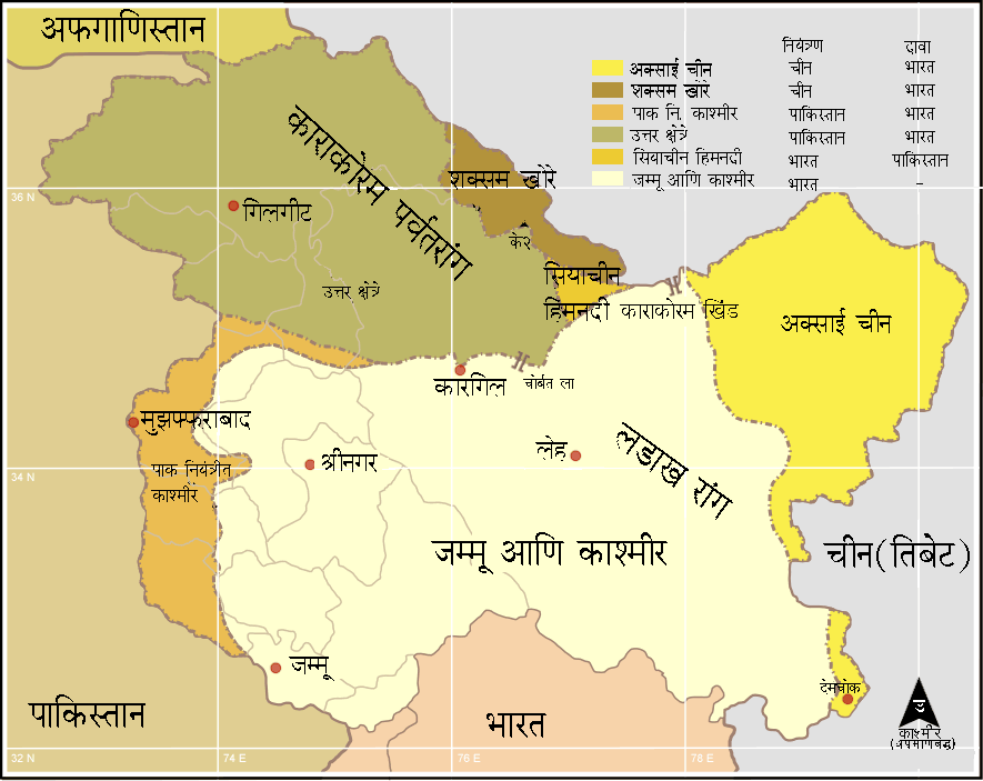
| Description | Kashmir region - Political and Military standoff between India, China and Pakistan The Jammu and kashmir region is admin by India and claimed by Pakistan. |
| Date | (UTC) |
| Source | |
| Author |
|
| This is a retouched picture, which means that it has been digitally altered from its original version. Modifications: Translated to marathi. The original can be viewed here: Map Kashmir Standoff 2003.png:
|
I, the copyright holder of this work, hereby publish it under the following licenses:
This file is licensed under the Creative Commons Attribution-Share Alike 2.5 Generic, 2.0 Generic and 1.0 Generic license.
- You are free:
- to share – to copy, distribute and transmit the work
- to remix – to adapt the work
- Under the following conditions:
- attribution – You must give appropriate credit, provide a link to the license, and indicate if changes were made. You may do so in any reasonable manner, but not in any way that suggests the licensor endorses you or your use.
- share alike – If you remix, transform, or build upon the material, you must distribute your contributions under the same or compatible license as the original.

|
Permission is granted to copy, distribute and/or modify this document under the terms of the GNU Free Documentation License, Version 1.2 or any later version published by the Free Software Foundation; with no Invariant Sections, no Front-Cover Texts, and no Back-Cover Texts. A copy of the license is included in the section entitled GNU Free Documentation License. |
| This file is licensed under the Creative Commons Attribution-Share Alike 3.0 Unported license. | ||
| ||
| This licensing tag was added to this file as part of the GFDL licensing update. |
You may select the license of your choice.
Original upload log[edit]
This image is a derivative work of the following images:
- File:Map_Kashmir_Standoff_2003.png licensed with Cc-by-sa-2.5,2.0,1.0, GFDL
- 2006-01-03T17:36:17Z Miljoshi 885x703 (59243 Bytes) Kashmir region - Political and Military standoff between India, China and Pakistan Reference: Atlas of the World (2003 Comprehensive Ed.) - The [[w:Royal Geographic Society]] - [[w:ISBN 0540084050]] - Self-made.
Uploaded with derivativeFX
File history
Click on a date/time to view the file as it appeared at that time.
| Date/Time | Thumbnail | Dimensions | User | Comment | |
|---|---|---|---|---|---|
| current | 09:42, 10 April 2009 | | 885 × 703 (38 KB) | कोल्हापुरी (talk | contribs) | |
| 09:32, 10 April 2009 |  | 885 × 703 (38 KB) | कोल्हापुरी (talk | contribs) | {{Information |Description=Kashmir region - Political and Military standoff between India, China and Pakistan The Jammu and kashmir region is admin by India and claimed by Pakistan. |Source=*File:Map_Kashmir_Standoff_2003.png |Date=2009-04-10 10:30 |
You cannot overwrite this file.
File usage on Commons
There are no pages that use this file.
File usage on other wikis
The following other wikis use this file:
- Usage on mr.wikipedia.org