File:Map Banaba Island 1936-en.svg

Original file (SVG file, nominally 750 × 545 pixels, file size: 49 KB)
Captions
Captions
Summary[edit]
| Description |
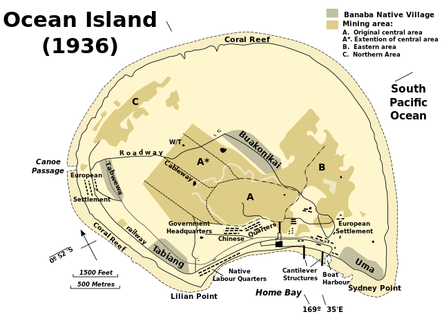
English: Banaba Island, Kiribati Español: Mapa de Banaba. Русский: Карта острова Банаба Српски / srpski: Карта острва Банаба |
||
| Date | |||
| Source | Indolences, utexas.edu | ||
| Author | Indolences | ||
| Permission (Reusing this file) |
|
||
| Other versions |
[]
|
||
| SVG development |


http://www.lib.utexas.edu/maps/historical/pacific_islands_1943_1945.html
http://www.lib.utexas.edu/usage_statement.html?maps=yes: "Most of the maps scanned by the University of Texas Libraries and served from this web site are in the public domain. No permissions are needed to copy them. You may download them and use them as you wish. A few maps are copyrighted, and are clearly marked as such."
This file is in the public domain because it has been taken from a collection of public domain maps at the University of Texas Library
|
File history
Click on a date/time to view the file as it appeared at that time.
| Date/Time | Thumbnail | Dimensions | User | Comment | |
|---|---|---|---|---|---|
| current | 18:00, 4 December 2010 | | 750 × 545 (49 KB) | Beao (talk | contribs) | Tweak. |
| 17:58, 4 December 2010 |  | 750 × 545 (50 KB) | Beao (talk | contribs) | Transparent. | |
| 20:04, 22 April 2010 |  | 750 × 545 (69 KB) | Ras67 (talk | contribs) | position | |
| 19:57, 22 April 2010 |  | 730 × 545 (69 KB) | Ras67 (talk | contribs) | frame removed | |
| 05:13, 19 March 2007 |  | 770 × 550 (63 KB) | Indolences (talk | contribs) | ||
| 14:44, 20 February 2007 |  | 770 × 550 (77 KB) | Indolences (talk | contribs) | ||
| 04:30, 20 February 2007 |  | 770 × 550 (77 KB) | Indolences (talk | contribs) | ||
| 04:20, 20 February 2007 |  | 756 × 530 (79 KB) | Indolences (talk | contribs) | ||
| 04:18, 20 February 2007 | 71 × 9 (79 KB) | Indolences (talk | contribs) | |||
| 04:17, 20 February 2007 |  | 756 × 510 (79 KB) | Indolences (talk | contribs) |
You cannot overwrite this file.
File usage on Commons
The following 10 pages use this file:
- Commons:Graphic Lab/Illustration workshop/Archive/2022
- File:Banaba Island.svg (file redirect)
- File:Banaba Island romanian.svg
- File:Map Banaba Island 1936-en.svg
- File:Map Banaba Island 1936-fr.svg
- File:Map Banaba Island 1936-mk.svg
- File:Map Banaba Island 1936-sr.svg
- File:Ocean island.jpg
- Template:Other versions/Map Banaba Island 1936
File usage on other wikis
The following other wikis use this file:
- Usage on ar.wikipedia.org
- Usage on de.wikipedia.org
- Usage on el.wikipedia.org
- Usage on en.wikipedia.org
- Usage on es.wikipedia.org
- Usage on et.wikipedia.org
- Usage on fi.wikipedia.org
- Usage on gl.wikipedia.org
- Usage on it.wikipedia.org
- Usage on ja.wikipedia.org
- Usage on ka.wikipedia.org
- Usage on kk.wikipedia.org
- Usage on ko.wikipedia.org
- Usage on nl.wikipedia.org
- Usage on no.wikipedia.org
- Usage on pl.wikipedia.org
- Usage on pt.wikipedia.org
- Usage on ru.wikipedia.org
- Usage on uk.wikipedia.org
- Usage on vi.wikipedia.org