File:Map00263 (27670860183).jpg
Jump to navigation
Jump to search

Size of this preview: 800 × 403 pixels. Other resolutions: 320 × 161 pixels | 640 × 323 pixels | 1,024 × 516 pixels | 1,280 × 645 pixels | 2,700 × 1,361 pixels.
Original file (2,700 × 1,361 pixels, file size: 850 KB, MIME type: image/jpeg)
Captions
Captions
Add a one-line explanation of what this file represents
Summary[edit]
.jpg&action=edit§ion=1)
| Description |
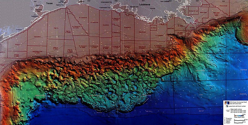
3-D image of the floor of the northern Gulf of Mexico. This image was derived primarily from NOAA EEZ mapping project multi-beam datasets and earlier single -beam datasets. The geology of this area is relatively unique as the Texas-Louisiana slope is underlain by vast salt deposits. These form both the diapiric structures called salt domes such as the large structures SE of the Mississippi passes and the ex-solution basins that are characteristic of the central slope area. Image ID: map00263, Voyage To Inner Space - Exploring the Seas With NOAA Collect Location: Gulf of Mexico, Texas-Louisiana SlopeCredit: Dr. Harry Roberts, Louisiana State University |
| Date | |
| Source | map00263 |
| Author | NOAA Photo Library |
Licensing[edit]
.jpg&action=edit§ion=2)
This file is licensed under the Creative Commons Attribution 2.0 Generic license.
- You are free:
- to share – to copy, distribute and transmit the work
- to remix – to adapt the work
- Under the following conditions:
- attribution – You must give appropriate credit, provide a link to the license, and indicate if changes were made. You may do so in any reasonable manner, but not in any way that suggests the licensor endorses you or your use.
| This image was originally posted to Flickr by NOAA Photo Library at https://flickr.com/photos/51647007@N08/27670860183. It was reviewed on 25 October 2017 by FlickreviewR and was confirmed to be licensed under the terms of the cc-by-2.0. |
File history
Click on a date/time to view the file as it appeared at that time.
| Date/Time | Thumbnail | Dimensions | User | Comment | |
|---|---|---|---|---|---|
| current | 23:43, 25 October 2017 | | 2,700 × 1,361 (850 KB) | Artix Kreiger (talk | contribs) | Transferred from Flickr via Flickr2Commons |
You cannot overwrite this file.
File usage on Commons
The following page uses this file:
- File:Bathy map00263 (27670860183).jpg (file redirect)
.jpg&redirect=no)
.jpg&oldid=554662753)