File:Manchester Docks (Salford Quays) 1979 - geograph.org.uk - 812843.jpg
Manchester_Docks_(Salford_Quays)_1979_-_geograph.org.uk_-_812843.jpg (640 × 427 pixels, file size: 46 KB, MIME type: image/jpeg)
Captions
Captions
Summary[edit]
_1979_-_geograph.org.uk_-_812843.jpg&action=edit§ion=1)
| Description |
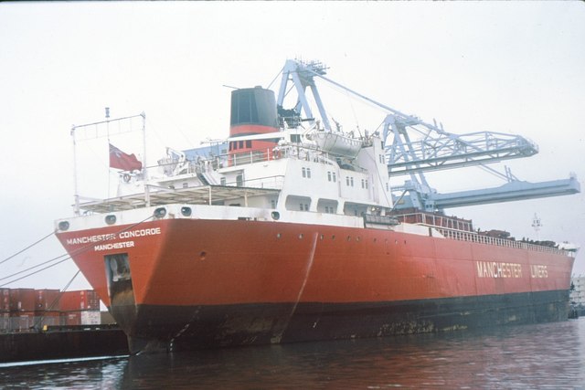
English: Manchester Docks (Salford Quays) 1979, 3 km from Trafford Park, Trafford, Great Britain.
One of Manchester Liners fleet of container vessels being loaded in the largest berth at Manchester Docks, April 1979. The area was rebranded as Salford Quays in the 1990s and features principally service industries and apartments. Vessels such as that pictured, carefully designed to fit the loading gauge of the Manchester Ship Canal, were eventually made obsolete by ever-rising ship sizes. Manchester Liners abandoned the port of Manchester for Liverpool Seaforth Dock in the 1980s.
History
|
| Date | |
| Source | From this image at geograph.org.uk; transferred by User:RHaworth using geograph_org2commons. |
| Author | Whatlep |
| Permission (Reusing this file) |
Creative Commons Attribution Share-alike license 2.0 |
| Camera location | | View this and other nearby images on: OpenStreetMap |
|---|
_1979_-_geograph.org.uk_-_812843.jpg¶ms=053.471350_N_-002.294632_E_globe:Earth_type:camera_heading:45.00_source:geograph&language=en)
| Object location | | View this and other nearby images on: OpenStreetMap |
|---|
_1979_-_geograph.org.uk_-_812843.jpg¶ms=053.472480_N_-002.292900_E_globe:Earth_class:object_type:object_source:geograph-osgb36(SJ80659734)_region:GB-EAW_heading:45.00&language=en)
Licensing[edit]
_1979_-_geograph.org.uk_-_812843.jpg&action=edit§ion=2)

|
This image was taken from the Geograph project collection. See this photograph's page on the Geograph website for the photographer's contact details. The copyright on this image is owned by Whatlep and is licensed for reuse under the Creative Commons Attribution-ShareAlike 2.0 license.
|
- You are free:
- to share – to copy, distribute and transmit the work
- to remix – to adapt the work
- Under the following conditions:
- attribution – You must give appropriate credit, provide a link to the license, and indicate if changes were made. You may do so in any reasonable manner, but not in any way that suggests the licensor endorses you or your use.
- share alike – If you remix, transform, or build upon the material, you must distribute your contributions under the same or compatible license as the original.
File history
Click on a date/time to view the file as it appeared at that time.
| Date/Time | Thumbnail | Dimensions | User | Comment | |
|---|---|---|---|---|---|
| current | 23:12, 14 April 2010 | | 640 × 427 (46 KB) | File Upload Bot (Magnus Manske) (talk | contribs) | == {{int:filedesc}} == {{Information |Description={{en|1=Manchester Docks (Salford Quays) 1979, 3 km from Trafford Park, Trafford, Great Britain. One of Manchester Liners fleet of container vessels being loaded in the largest berth at Manchester Docks, Ap |
You cannot overwrite this file.
File usage on Commons
The following 2 pages use this file:
File usage on other wikis
The following other wikis use this file:
- Usage on de.wikipedia.org
- Usage on en.wikipedia.org
- Usage on nl.wikipedia.org
- Usage on www.wikidata.org
_1979_-_geograph.org.uk_-_812843.jpg&oldid=716069810)