File:London Bridge Low Level geograph-2653722-by-Ben-Brooksbank.jpg
Jump to navigation
Jump to search
Size of this preview: 800 × 476 pixels. Other resolutions: 320 × 190 pixels | 640 × 380 pixels | 1,196 × 711 pixels.
Original file (1,196 × 711 pixels, file size: 303 KB, MIME type: image/jpeg)
Captions
Captions
Add a one-line explanation of what this file represents
Summary[edit]
| Description |
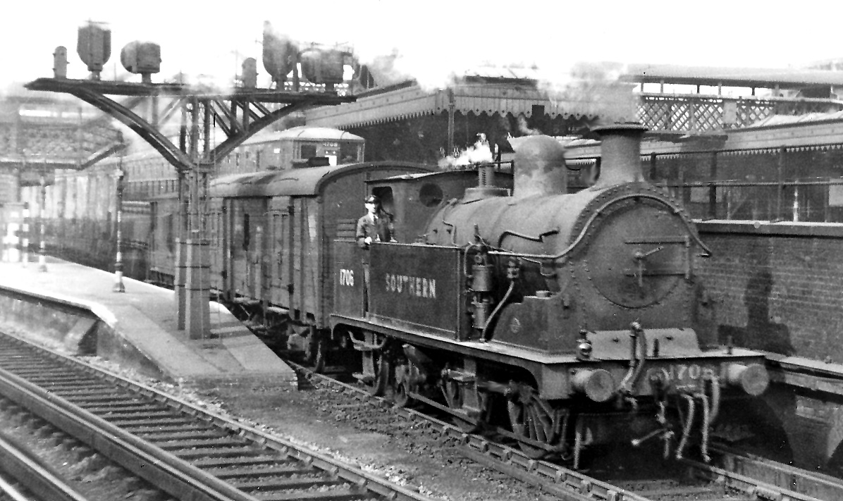
English: Ex-LC&DR 0-4-4T at London Bridge Low Level. A relic from London, Chatham & Dover days, Kirtley R1 class 0-4-4T No. 1706 (built 12/1900, withdrawn 11/52) is on station-pilot duties. These 'Low Level' (un-roofed) platforms, Nos. 8 - 10, were the original terminus of 1836-39 of the London & Greenwich and London & Croydon Railways. Above and to the right are Platforms 1 - 7 of the through lines of the Eastern Section (ex-SER) running to Cannon Street and Charing Cross: out of frame to the left is the main LB&SCR terminus, Platforms 12- 22. |
| Date | |
| Source | From geograph.org.uk |
| Author | Ben Brooksbank |
| Permission (Reusing this file) |
Creative Commons Attribution Share-alike license 2.0 |
| Attribution (required by the license) | Ben Brooksbank / Ex-LC&DR 0-4-4T at London Bridge Low Level / |
| Camera location | | View this and other nearby images on: OpenStreetMap |
|---|
Licensing[edit]

|
This image was taken from the Geograph project collection. See this photograph's page on the Geograph website for the photographer's contact details. The copyright on this image is owned by Ben Brooksbank and is licensed for reuse under the Creative Commons Attribution-ShareAlike 2.0 license.
|
This file is licensed under the Creative Commons Attribution-Share Alike 2.0 Generic license.
Attribution: Ben Brooksbank
- You are free:
- to share – to copy, distribute and transmit the work
- to remix – to adapt the work
- Under the following conditions:
- attribution – You must give appropriate credit, provide a link to the license, and indicate if changes were made. You may do so in any reasonable manner, but not in any way that suggests the licensor endorses you or your use.
- share alike – If you remix, transform, or build upon the material, you must distribute your contributions under the same or compatible license as the original.
File history
Click on a date/time to view the file as it appeared at that time.
| Date/Time | Thumbnail | Dimensions | User | Comment | |
|---|---|---|---|---|---|
| current | 12:37, 23 October 2011 | | 1,196 × 711 (303 KB) | Chevin (talk | contribs) | == {{int:filedesc}} == {{Information |Description={{en|1='''Ex-LC&DR 0-4-4T at London Bridge Low Level.'''<br/> A relic from London, Chatham & Dover days, Kirtley R1 class 0-4-4T No. 1706 (built 12/1900, withdrawn 11/52) is on station-pilot duties. These |
You cannot overwrite this file.
File usage on Commons
There are no pages that use this file.
File usage on other wikis
The following other wikis use this file:
- Usage on de.wikipedia.org
- Usage on en.wikipedia.org
- Usage on www.wikidata.org