File:Liverpool Overhead Railway map.png
Jump to navigation
Jump to search
Size of this preview: 267 × 599 pixels. Other resolutions: 107 × 240 pixels | 214 × 480 pixels | 342 × 768 pixels | 457 × 1,024 pixels | 2,500 × 5,604 pixels.
Original file (2,500 × 5,604 pixels, file size: 3.49 MB, MIME type: image/png)
Captions
Captions
Add a one-line explanation of what this file represents
Summary[edit]
| Description |
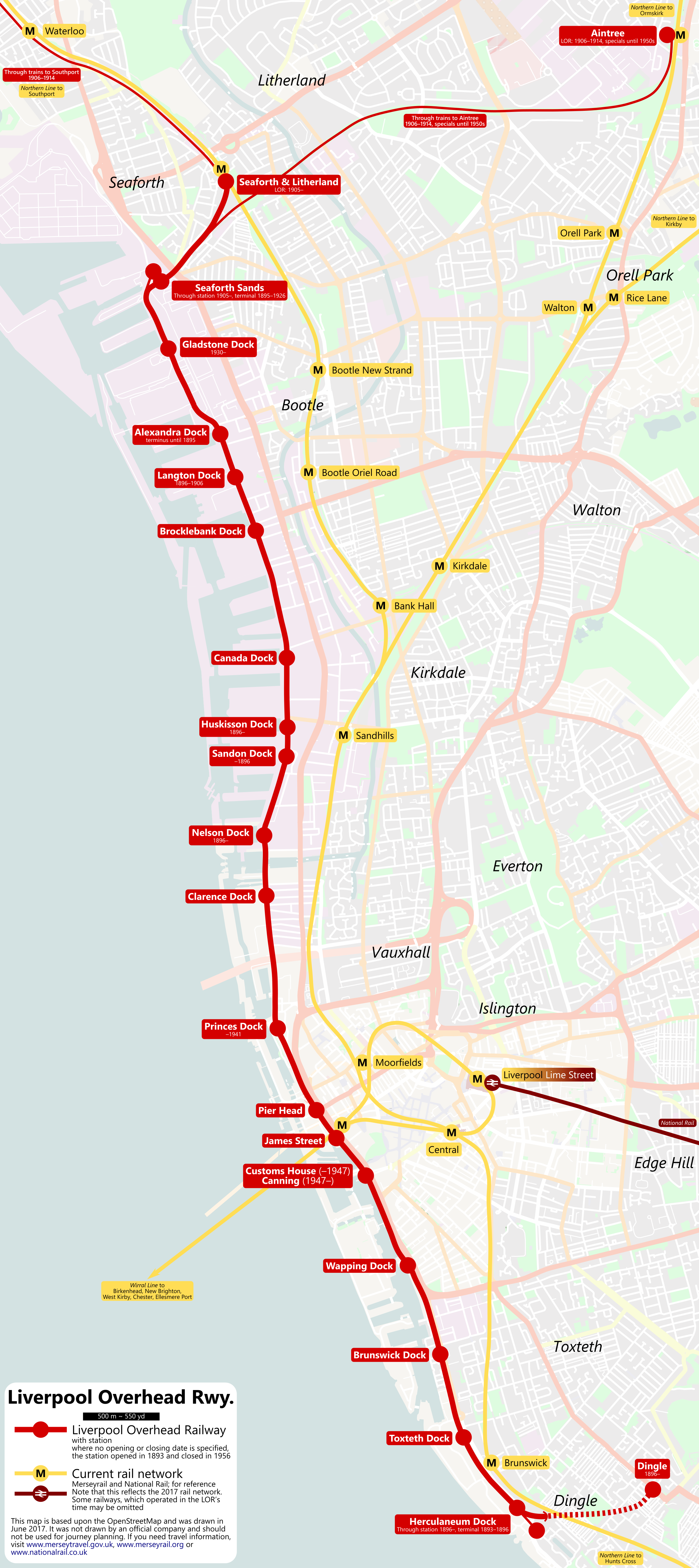
English: Geographical map of the Liverpool Overhead Railway. For reference, the current Liverpool rail network (Merseyrail and National Rail) is also shown. Of the LOR stations, the opening and closing date, if it is not the line’s overall opening in 1893 and closing in 1956, are noted beneath the station name.
Note, because it is not relevant for a LOR map, the Birkenhead area has been omitted.
Deutsch: Eine geographische Karte der Liverpool Overhead Railway. Zur Illustration ist außerdem noch das aktuelle Bahnnetz in Liverpool, bestehend aus Merseyrail und National Rail ebenfalls enthalten. An den LOR-Bahnhöfen sind, sofern sie von der generellen Daten der Strecke (1893–1956), außerdem die Eröffnungs- und Stilllegungsjahre angegeben.
Hinweis: da es für eine LOR-Karte nicht relevant ist, wurde das Gebiet um Birkenhead entfernt. |
| Date | |
| Source | OpenStreetMap |
| Author | OpenStreetMap-Contributors, Metrophil |
Licensing[edit]
| Description |
This map was created from OpenStreetMap project data, collected by the community. This map may be incomplete, and may contain errors. Don't rely solely on it for navigation. |
|||
| Date | (see file history) | |||
| Source | openstreetmap.org | |||
| Creator |
OpenStreetMap contributors |
|||
| Permission (Reusing this file) |
OpenStreetMap data is available under the Open Database License (details). Map tiles are licensed under the Creative Commons Attribution-ShareAlike 2.0 license (CC-BY-SA 2.0).
This file is licensed under the Creative Commons Attribution-Share Alike 2.0 Generic license.
|
|||
| Georeferencing | If inappropriate please set warp_status = skip to hide. |
File history
Click on a date/time to view the file as it appeared at that time.
| Date/Time | Thumbnail | Dimensions | User | Comment | |
|---|---|---|---|---|---|
| current | 16:21, 23 June 2017 | | 2,500 × 5,604 (3.49 MB) | Metrophil (talk | contribs) | Removed mistakes, thanks to ''Fawkes Cat'' on [http://www.railforums.co.uk www.railforums.co.uk] |
| 20:24, 16 June 2017 |  | 2,500 × 5,604 (3.52 MB) | Metrophil (talk | contribs) | User created page with UploadWizard |
You cannot overwrite this file.
File usage on Commons
The following 12 pages use this file:
- Transport in Merseyside
- User:Chumwa/OgreBot/Potential transport maps/2017 June 11-20
- User:Chumwa/OgreBot/Potential transport maps/2017 June 21-30
- User:Chumwa/OgreBot/Public transport information/2017 June 11-20
- User:Chumwa/OgreBot/Public transport information/2017 June 21-30
- User:Chumwa/OgreBot/Transport Maps/2017 June 11-20
- User:Chumwa/OgreBot/Transport Maps/2017 June 21-30
- User:Chumwa/OgreBot/Travel and communication maps/2017 June 11-20
- User:Chumwa/OgreBot/Travel and communication maps/2017 June 21-30
- User:Mattbuck/Railways/2017 June 11-20
- User:Mattbuck/Railways/2017 June 21-30
- Category:Liverpool Overhead Railway
File usage on other wikis
The following other wikis use this file:
- Usage on de.wikipedia.org
- Usage on en.wikipedia.org
- Usage on pl.wikipedia.org
- Usage on ru.wikipedia.org
- Usage on uk.wikipedia.org
- Usage on www.wikidata.org