File:Liechtenstein topographic map-ru.svg
Jump to navigation
Jump to search

Size of this PNG preview of this SVG file: 459 × 599 pixels. Other resolutions: 184 × 240 pixels | 368 × 480 pixels | 589 × 768 pixels | 785 × 1,024 pixels | 1,570 × 2,048 pixels | 1,301 × 1,697 pixels.
Original file (SVG file, nominally 1,301 × 1,697 pixels, file size: 2 MB)
Captions
Captions
Add a one-line explanation of what this file represents

| Description |
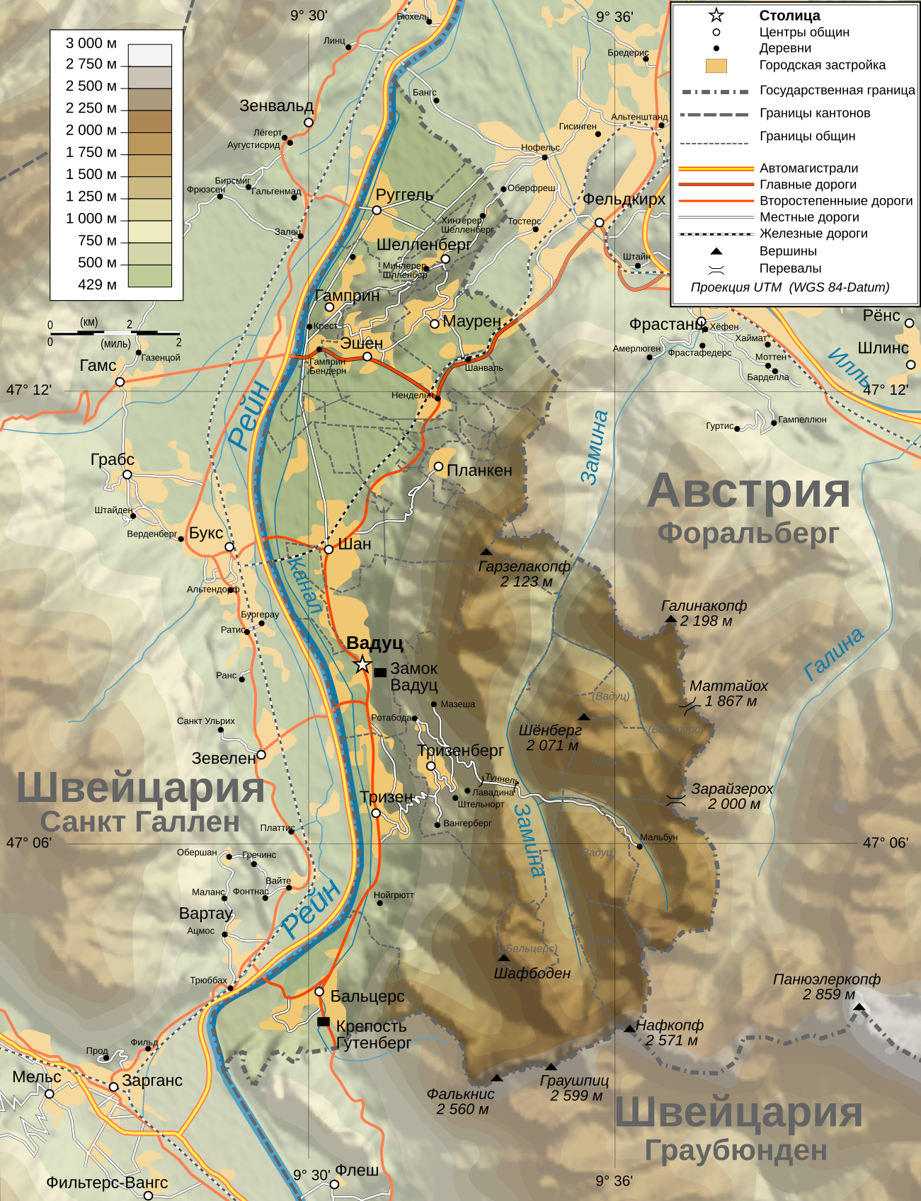
Deutsch: Topographische Karte von Liechtenstein, russische Version English: Topographic map in Russian of Liechtenstein Русский: Физическая ката Лихтенштейна |
| Date | (UTC) |
| Source | |
| Author |
|
| Other versions |
|


| This is a retouched picture, which means that it has been digitally altered from its original version. Modifications: Translated. The original can be viewed here: Liechtenstein topographic map-de.svg:
|
I, the copyright holder of this work, hereby publish it under the following licenses:
This file is licensed under the Creative Commons Attribution-Share Alike 3.0 Unported, 2.5 Generic, 2.0 Generic and 1.0 Generic license.
- You are free:
- to share – to copy, distribute and transmit the work
- to remix – to adapt the work
- Under the following conditions:
- attribution – You must give appropriate credit, provide a link to the license, and indicate if changes were made. You may do so in any reasonable manner, but not in any way that suggests the licensor endorses you or your use.
- share alike – If you remix, transform, or build upon the material, you must distribute your contributions under the same or compatible license as the original.

|
Permission is granted to copy, distribute and/or modify this document under the terms of the GNU Free Documentation License, Version 1.2 or any later version published by the Free Software Foundation; with no Invariant Sections, no Front-Cover Texts, and no Back-Cover Texts. A copy of the license is included in the section entitled GNU Free Documentation License. |
You may select the license of your choice.
Original upload log[edit]
This image is a derivative work of the following images:
- File:Liechtenstein_topographic_map-de.svg licensed with Cc-by-sa-3.0,2.5,2.0,1.0, GFDL
- 2009-07-21T20:16:30Z NordNordWest 1301x1697 (2100171 Bytes)
- 2009-07-20T18:03:53Z NordNordWest 1301x1697 (2100173 Bytes)
- 2009-07-19T17:36:43Z NordNordWest 1301x1697 (2099039 Bytes)
- 2009-07-18T17:52:03Z NordNordWest 1301x1697 (2103435 Bytes) == Summary == {{Information |Description={{de|Topographische Karte von [[:de:Liechtenstein|Liechtenstein]], deutsche Version}}{{en|Topographic map in German of [[:en:Liechtenstein|Liechtenstein]]}}{{fr|Carte topographique en
Uploaded with derivativeFX
File history
Click on a date/time to view the file as it appeared at that time.
| Date/Time | Thumbnail | Dimensions | User | Comment | |
|---|---|---|---|---|---|
| current | 06:37, 2 November 2009 | | 1,301 × 1,697 (2 MB) | Il Dottore (talk | contribs) | перевод |
| 06:35, 2 November 2009 |  | 1,301 × 1,697 (2 MB) | Il Dottore (talk | contribs) | Перевод непереведённых названий | |
| 07:16, 31 October 2009 |  | 1,301 × 1,697 (2 MB) | DerFuchs (talk | contribs) | {{Information |Description={{de|Topographische Karte von Liechtenstein, deutsche Version}}{{en|Topographic map in German of Liechtenstein}}{{fr|Carte topographique en allemand du [[:fr:Liechtenstein|Liechtenstei |
You cannot overwrite this file.
File usage on Commons
The following 3 pages use this file:
File usage on other wikis
The following other wikis use this file:
- Usage on ru.wikipedia.org
- Usage on sr.wikipedia.org