File:Liège and Luxemburg 1618.png
Jump to navigation
Jump to search

Size of this preview: 394 × 600 pixels. Other resolutions: 158 × 240 pixels | 412 × 627 pixels.
Original file (412 × 627 pixels, file size: 105 KB, MIME type: image/png)
Captions
Captions
Add a one-line explanation of what this file represents
Summary[edit]
| Description |
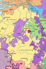
English: Liège and Luxemburg and surrounding territories in 1618. |
| Date | |
| Source | File:Map of the Holy Roman Empire (1618) - DE.svg |
| Author | Sir Iain |
_-_DE.svg)
Licensing[edit]
This file is licensed under the Creative Commons Attribution-Share Alike 4.0 International license.
- You are free:
- to share – to copy, distribute and transmit the work
- to remix – to adapt the work
- Under the following conditions:
- attribution – You must give appropriate credit, provide a link to the license, and indicate if changes were made. You may do so in any reasonable manner, but not in any way that suggests the licensor endorses you or your use.
- share alike – If you remix, transform, or build upon the material, you must distribute your contributions under the same or compatible license as the original.
File history
Click on a date/time to view the file as it appeared at that time.
| Date/Time | Thumbnail | Dimensions | User | Comment | |
|---|---|---|---|---|---|
| current | 16:42, 7 May 2021 | | 412 × 627 (105 KB) | Nederlandse Leeuw (talk | contribs) | Uploaded a work by Sir Iain from File:Map of the Holy Roman Empire (1618) - DE.svg with UploadWizard |
You cannot overwrite this file.
File usage on Commons
The following page uses this file:
File usage on other wikis
The following other wikis use this file:
- Usage on en.wikipedia.org
- Usage on fr.wikipedia.org
- Usage on nl.wikipedia.org
Metadata
Categories:
- Maps of the territories of the Holy Roman Empire
- Duchy of Luxembourg
- Principality of Sedan
- Duchy of Bouillon
- Maps of the Prince-Bishopric of Liège
- Spanish Netherlands in the 1610s
- Duchy of Jülich
- Duchy of Cleves
- Electorate of Cologne
- Electorate of Trier
- Duchy of Brabant
- Republic of the Seven United Netherlands