File:Le Gan Chenpo (Himalaya, Népal) (8446635289).jpg
Jump to navigation
Jump to search

Size of this preview: 799 × 599 pixels. Other resolutions: 320 × 240 pixels | 640 × 480 pixels | 1,024 × 768 pixels | 1,280 × 960 pixels | 1,365 × 1,024 pixels.
Original file (1,365 × 1,024 pixels, file size: 1.28 MB, MIME type: image/jpeg)
Captions
Captions
Add a one-line explanation of what this file represents
Summary[edit]
_(8446635289).jpg&action=edit§ion=1)
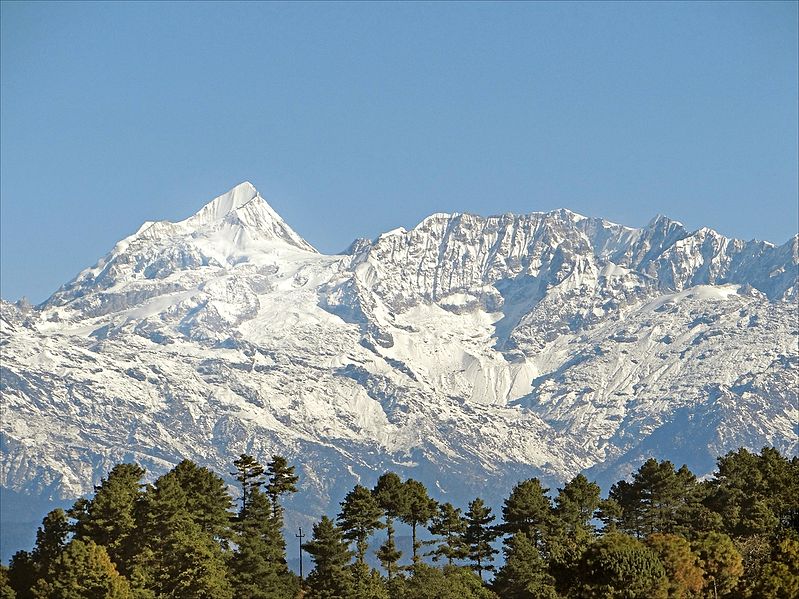
| Description | South face of Gangchempo (Fluted Peak) 6387 m, as seen from Nagarkot at 1980 m. Nagarkot is a village in the Bhaktapur district of Nepal, about 32 kilometres (20 mi) east of Kathmandu and 14 kilometres (9 mi) northeast of Bhaktapur. Nagarkot is located at the top of the mountains to the east of the Kathmandu Valley. The view is of the "Langtang Himalayan Range". |
| Date | Taken on 21 January 2013, 09:03 |
| Source | Le Gan Chenpo (Himalaya, Népal) |
| Author | Jean-Pierre Dalbéra from Paris, France |
| Camera location | | View this and other nearby images on: OpenStreetMap |
|---|
_(8446635289).jpg¶ms=027.717463_N_0085.520466_E_globe:Earth_type:camera_source:Flickr_&language=en)
Licensing[edit]
_(8446635289).jpg&action=edit§ion=2)
This file is licensed under the Creative Commons Attribution 2.0 Generic license.
- You are free:
- to share – to copy, distribute and transmit the work
- to remix – to adapt the work
- Under the following conditions:
- attribution – You must give appropriate credit, provide a link to the license, and indicate if changes were made. You may do so in any reasonable manner, but not in any way that suggests the licensor endorses you or your use.
| This image, originally posted to Flickr, was reviewed on 15 February 2013 by the administrator or reviewer File Upload Bot (Magnus Manske), who confirmed that it was available on Flickr under the stated license on that date. |
| Annotations | This image is annotated: View the annotations at Commons |
_(8446635289).jpg)
File history
Click on a date/time to view the file as it appeared at that time.
| Date/Time | Thumbnail | Dimensions | User | Comment | |
|---|---|---|---|---|---|
| current | 15:19, 15 February 2013 | | 1,365 × 1,024 (1.28 MB) | File Upload Bot (Magnus Manske) (talk | contribs) | Transferred from Flickr by User:russavia |
You cannot overwrite this file.
File usage on Commons
The following page uses this file:
File usage on other wikis
The following other wikis use this file:
- Usage on dty.wikipedia.org
- Usage on en.wikiquote.org
- Usage on et.wikipedia.org
- Usage on hi.wikipedia.org
- Usage on it.wikivoyage.org
- Usage on kbp.wikipedia.org
- Usage on mai.wikipedia.org
- Usage on ms.wikipedia.org
- Usage on new.wikipedia.org
_(8446635289).jpg&oldid=874840422)