File:Lake powell utah.jpg
Jump to navigation
Jump to search
Size of this preview: 463 × 599 pixels. Other resolutions: 185 × 240 pixels | 371 × 480 pixels | 773 × 1,000 pixels.
Original file (773 × 1,000 pixels, file size: 193 KB, MIME type: image/jpeg)
Captions
Captions
Add a one-line explanation of what this file represents
Summary[edit]
| Description |
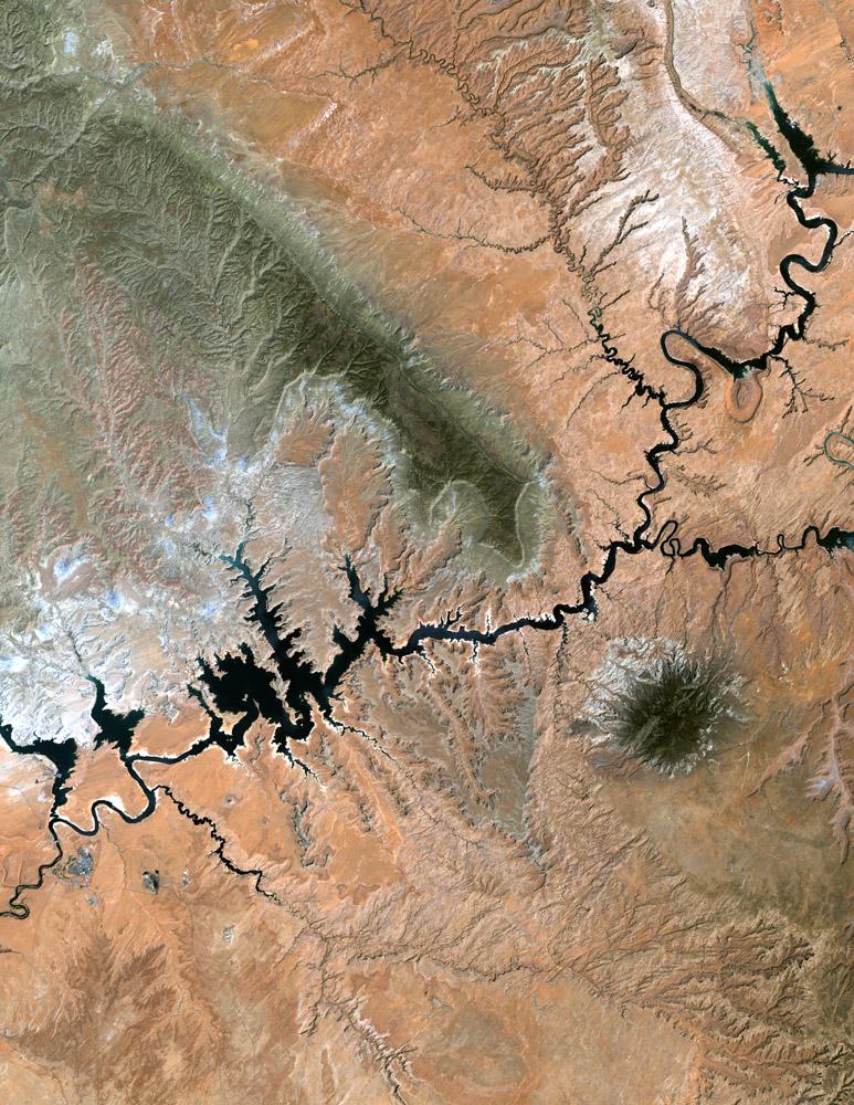
Français : Vue satellite de la NASA du Lac Powell dans l'état de l'Utah. La zone verte au centre de la photo est le Plateau de Kaiparowits English: Lake Powell, Utah from NASA's Landsat
Lake Powell in southern Utah stretches hundreds of miles from Lees Ferry in Arizona to the Orange Cliffs of southern Utah. At more than 400 feet deep, 150 miles long, and nearly 2,000 miles of shoreline, Lake Powell is the nation's second largest man-made lake, second only to Lake Mead in Nevada. It is at its lowest water level in over 30 years due to the ongoing drought in the western United States. |
| Source | http://landsat.usgs.gov/gallery/detail/397/ |
| Author |
Licensing[edit]
| This file is in the public domain in the United States because it was solely created by NASA. NASA copyright policy states that "NASA material is not protected by copyright unless noted". (See Template:PD-USGov, NASA copyright policy page or JPL Image Use Policy.) | ||
 |
Warnings:
|
Original upload log[edit]
The original description page was here. All following user names refer to en.wikipedia.
- 2005-03-22 11:34 Darwinek 773×1000× (197249 bytes)
Licensing[edit]
| This file is in the public domain in the United States because it was solely created by NASA. NASA copyright policy states that "NASA material is not protected by copyright unless noted". (See Template:PD-USGov, NASA copyright policy page or JPL Image Use Policy.) | ||
|
Warnings:
|
| Annotations | This image is annotated: View the annotations at Commons |
File history
Click on a date/time to view the file as it appeared at that time.
| Date/Time | Thumbnail | Dimensions | User | Comment | |
|---|---|---|---|---|---|
| current | 20:53, 14 March 2009 | | 773 × 1,000 (193 KB) | Sylfred1977 (talk | contribs) | {{Information |Description={{fr|Vue satellite de la NASA du Lac Powell dans l'état de l'Utah. La zone verte au centre de la photo est le Plateau de Kaiparowits}} {{en|Lake Powell, Utah from NASA's Landsat Lake Powell in southern Utah stretches hundreds |
You cannot overwrite this file.
File usage on Commons
There are no pages that use this file.
File usage on other wikis
The following other wikis use this file:
- Usage on ar.wikipedia.org
- Usage on ceb.wikipedia.org
- Usage on en.wikipedia.org
- Usage on fr.wikipedia.org
- Usage on ja.wikipedia.org
- Usage on lt.wikipedia.org