File:La Pextina (1945 Vol Americà sèrie A).png
Jump to navigation
Jump to search

Size of this preview: 622 × 599 pixels. Other resolutions: 249 × 240 pixels | 498 × 480 pixels | 980 × 944 pixels.
Original file (980 × 944 pixels, file size: 993 KB, MIME type: image/png)
Captions
Captions
Add a one-line explanation of what this file represents
Summary
[edit].png&action=edit§ion=1)
| Description |
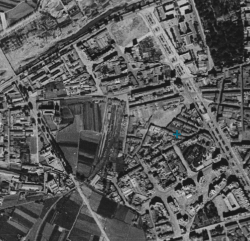
Español: Fotografía aérea del barrio La Petxina tomada en 1945 por personal del Servicio de Mapas del Ejército (Army Map Service) de los Estados Unidos de América.
Català: Fotografia aèria del barri de La Petxina presa a 1945 per personal del Servei de Mapes de l'Èxèrcit (Army Map Service) dels Estats Units d'Amèrica. |
| Date | |
| Source | Institut Cartogràfic Valencià. [1] |
| Author | Unknown author |
Licensing
[edit].png&action=edit§ion=2)
This file is licensed under the Creative Commons Attribution 4.0 International license.
- You are free:
- to share – to copy, distribute and transmit the work
- to remix – to adapt the work
- Under the following conditions:
- attribution – You must give appropriate credit, provide a link to the license, and indicate if changes were made. You may do so in any reasonable manner, but not in any way that suggests the licensor endorses you or your use.
File history
Click on a date/time to view the file as it appeared at that time.
| Date/Time | Thumbnail | Dimensions | User | Comment | |
|---|---|---|---|---|---|
| current | 18:42, 19 March 2024 | | 980 × 944 (993 KB) | MP DDT (talk | contribs) | Uploaded a work by {{Unknown|author}} from Institut Cartogràfic Valencià. [https://geofototeca.gva.es/visor_fototeca/] with UploadWizard |
You cannot overwrite this file.
File usage on Commons
There are no pages that use this file.
File usage on other wikis
The following other wikis use this file:
- Usage on es.wikipedia.org
.png&oldid=861990044)