File:Krakau Stadtplan 1896.jpg
Jump to navigation
Jump to search
Size of this preview: 462 × 599 pixels. Other resolutions: 185 × 240 pixels | 592 × 768 pixels.
Original file (592 × 768 pixels, file size: 118 KB, MIME type: image/jpeg)
Captions
Captions
Add a one-line explanation of what this file represents
Summary
[edit]
| Description |
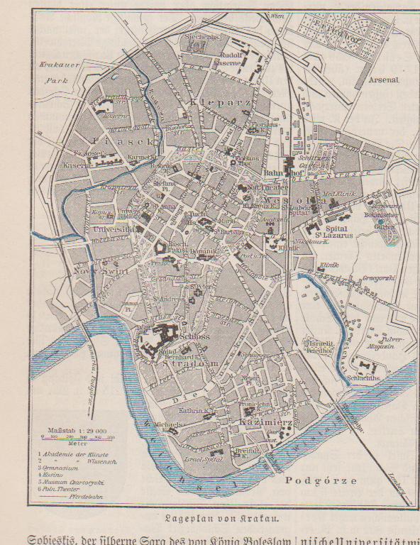
English: City map of Cracow, then a city in Imperial Austria's crown-land Galicia, published in a German encyclopedia (17 volumes) in 1896
Deutsch: Stadtplan von Krakau, damals im Kronland Galizien des k.k. Österreich, abgedruckt in einem 17-bändigen deutschen Lexikon 1896 |
| Date | |
| Source | Meyers Konversations-Lexikon, 10. Band, Bibliographisches Institut Leipzig und Wien 1896, S. 622 |
| Author | Unknown author |
Licensing
[edit]
| I, the copyright holder of this work, release this work into the public domain. This applies worldwide. In some countries this may not be legally possible; if so: I grant anyone the right to use this work for any purpose, without any conditions, unless such conditions are required by law. |
File history
Click on a date/time to view the file as it appeared at that time.
| Date/Time | Thumbnail | Dimensions | User | Comment | |
|---|---|---|---|---|---|
| current | 14:48, 14 July 2010 | | 592 × 768 (118 KB) | Wolfgang J. Kraus~commonswiki (talk | contribs) | {{Information |Description={{en|1=City map of Cracow, then a city in Imperial Austria's crown-land Galicia, published in a German encyclopedia (17 volumes) in 1896 }} {{de|1=Stadtplan von Krakau, damals im Kronland Galizien des k.k. Österreich, abgedruck |
You cannot overwrite this file.
File usage on Commons
There are no pages that use this file.
File usage on other wikis
The following other wikis use this file:
- Usage on de.wikipedia.org