File:KobeSubway.svg

Original file (SVG file, nominally 720 × 460 pixels, file size: 28 KB)
Captions
Captions
Summary
[edit]This file is translated using SVG <switch> elements. All translations are stored in the same file! Learn more.
For most Wikipedia projects, you can embed the file normally (without a To translate the text into your language, you can use the SVG Translate tool. Alternatively, you can download the file to your computer, add your translations using whatever software you're familiar with, and re-upload it with the same name. You will find help in Graphics Lab if you're not sure how to do this. |
File:KobeSubway.svg has 3 embedded translations.


| Description |
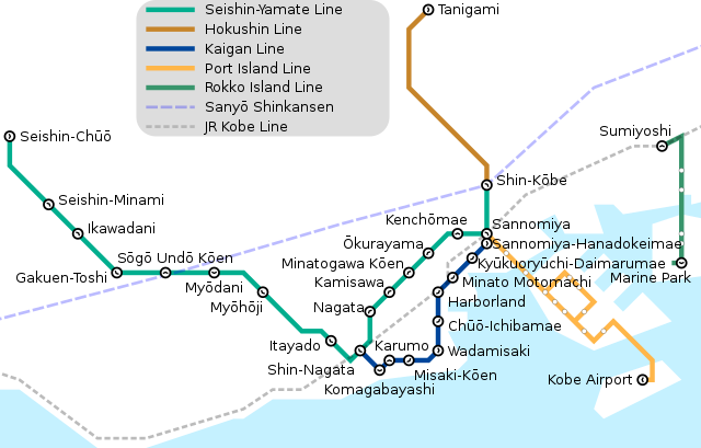
English: Subway map of Kōbe, showing the Seishin-Yamate Line, the Kaigan Line, the Port Island Line, and the Rokko Island Line, along with connections to Shinkansen and JR West. |
| Date | |
| Source |
Own work, redrawn from map data and inspired by the following existing documents: |
| Author |
Mliu92, from works previously created by: |
| Other versions |
This file was derived from: |


Licensing
[edit]
- You are free:
- to share – to copy, distribute and transmit the work
- to remix – to adapt the work
- Under the following conditions:
- attribution – You must give appropriate credit, provide a link to the license, and indicate if changes were made. You may do so in any reasonable manner, but not in any way that suggests the licensor endorses you or your use.
- share alike – If you remix, transform, or build upon the material, you must distribute your contributions under the same or compatible license as the original.
File history
Click on a date/time to view the file as it appeared at that time.
| Date/Time | Thumbnail | Dimensions | User | Comment | |
|---|---|---|---|---|---|
| current | 15:55, 24 July 2020 | | 720 × 460 (28 KB) | Mliu92 (talk | contribs) | Fixed broken ja-language switch. |
| 10:11, 21 February 2020 |  | 720 × 460 (24 KB) | Whidou (talk | contribs) | Add French translation | |
| 03:50, 3 July 2016 |  | 720 × 460 (23 KB) | Mliu92 (talk | contribs) | Fix broken <switch> tag for Seishin-Chuo | |
| 03:48, 3 July 2016 |  | 720 × 460 (23 KB) | Mliu92 (talk | contribs) | Illustrate split station at Sannomiya explicitly. | |
| 06:52, 2 July 2016 |  | 720 × 460 (23 KB) | Mliu92 (talk | contribs) | Shortened Japanese to vernacular "Port Liner" and "Rokko Liner" to better fit within legend. | |
| 06:39, 2 July 2016 |  | 720 × 460 (23 KB) | Mliu92 (talk | contribs) | Completed Japanese translation. | |
| 06:17, 2 July 2016 |  | 720 × 460 (21 KB) | Mliu92 (talk | contribs) | User created page with UploadWizard |
You cannot overwrite this file.
File usage on Commons
The following 14 pages use this file:
- User:Chumwa/OgreBot/Potential transport maps/2016 July 1-10
- User:Chumwa/OgreBot/Public transport information/2016 July 1-10
- User:Chumwa/OgreBot/Public transport information/2020 February 20-29
- User:Chumwa/OgreBot/Public transport information/2020 July 21-31
- User:Chumwa/OgreBot/Transport Maps/2016 July 1-10
- User:Chumwa/OgreBot/Transport Maps/2020 February 20-29
- User:Chumwa/OgreBot/Transport Maps/2020 July 21-31
- User:Chumwa/OgreBot/Travel and communication maps/2016 July 1-10
- User:Magog the Ogre/Multilingual legend/2020 February 20-29
- User:콩가루/일본철도/2020 February
- User:콩가루/일본철도/2020 July
- File:KobeSubway.svg
- File:Kobe Subway Karte.png
- Category:Kobe Municipal Subway
File usage on other wikis
The following other wikis use this file:
- Usage on ca.wikipedia.org
- Usage on de.wikipedia.org
- Usage on de.wikivoyage.org
- Usage on en.wikipedia.org
- Usage on es.wikipedia.org
- Usage on eu.wikipedia.org
- Usage on fa.wikipedia.org
- Usage on fi.wikipedia.org
- Usage on fr.wikipedia.org
- Métro municipal de Kobe
- Komagabayashi (métro municipal de Kobe)
- Nagata (métro municipal de Kobe)
- Chūō-Ichibamae (métro municipal de Kobe)
- Harborland (métro municipal de Kobe)
- Ōkurayama (métro municipal de Kobe)
- Wadamisaki (métro municipal de Kobe)
- Karumo (métro municipal de Kobe)
- Minato Motomachi (métro municipal de Kobe)
- Kyukyoryuchi-Daimarumae (métro municipal de Kobe)
- Sannomiya-Hanadokeimae (métro municipal de Kobe)
- Tanigami (métro municipal de Kobe)
- Shin-Kōbe (métro municipal de Kobe)
- Sannomiya (métro municipal de Kobe)
- Kenchomae (métro municipal de Kobe)
- Minatogawa-koen (métro municipal de Kobe)
- Kamisawa (métro municipal de Kobe)
- Itayado (métro municipal de Kobe)
- Myōhōji (métro municipal de Kobe)
- Myōdani (métro municipal de Kobe)
- Sōgōundō-kōen (métro municipal de Kobe)
- Gakuentoshi (métro municipal de Kobe)
- Ikawadani (métro municipal de Kobe)
- Seishin-minami (métro municipal de Kobe)
- Seishin-chūō (métro municipal de Kobe)
- Usage on fr.wikivoyage.org
- Usage on he.wikivoyage.org
- Usage on hu.wikipedia.org
- Usage on it.wikipedia.org
- Usage on ko.wikipedia.org
- Usage on ms.wikipedia.org
- Usage on nl.wikipedia.org
- Usage on pl.wikipedia.org
- Usage on pt.wikipedia.org
- Usage on ru.wikipedia.org
- Usage on sv.wikipedia.org
- Usage on th.wikipedia.org
View more global usage of this file.