File:Knife River Indian Villages National Historic Site map.png
Jump to navigation
Jump to search
Size of this preview: 441 × 599 pixels. Other resolutions: 177 × 240 pixels | 353 × 480 pixels | 773 × 1,050 pixels.
Original file (773 × 1,050 pixels, file size: 293 KB, MIME type: image/png)
Captions
Captions
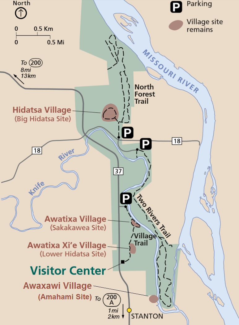
Map with some of the village sites of the Hidatsa at Knife River, North Dakota
Summary[edit]
| Description |
Dansk: Kortet viser beliggenheden af hidatsaernes byer Sakakawea (32ME11), Amahami (32ME8), Lower Hidatsa (32ME10) samt hovedbyen Big Hidatsa (32ME12) tæt ved Missouri River, North Dakota. Lokaliteterne ligger i eller tæt ved Knife River Indian Villages National Historic Site.
English: The map shows the sites of four Hidatsa villages in or near the Knife River Indian Villages National Historic Site, Mercer County, North Dakota.
Big Hidatsa Site (32ME12), Sakakawea Site (32ME11), Lower Hidatsa (32ME10) and (added to the original map) Amahami Site (32ME8). |
| Date | |
| Source | catalog.archives.gov – ”Knife River Indian Villages National Historic Site Map, Project years 2004-2012” |
| Author |
Dept. of the Interior. National Park Service. Harpers Ferry Center. Adapted to text about Sakakawea and Amahami - Amahami Village added to the original map |
Licensing[edit]
This work is in the public domain in the United States because it is a work prepared by an officer or employee of the United States Government as part of that person’s official duties under the terms of Title 17, Chapter 1, Section 105 of the US Code.
Note: This only applies to original works of the Federal Government and not to the work of any individual U.S. state, territory, commonwealth, county, municipality, or any other subdivision. This template also does not apply to postage stamp designs published by the United States Postal Service since 1978. (See § 313.6(C)(1) of Compendium of U.S. Copyright Office Practices). It also does not apply to certain US coins; see The US Mint Terms of Use.
|
 | |
| This file has been identified as being free of known restrictions under copyright law, including all related and neighboring rights. | ||

|
This is a file uploaded through the Danish Wikipedia, which has not been reviewed on Commons:
|
File history
Click on a date/time to view the file as it appeared at that time.
| Date/Time | Thumbnail | Dimensions | User | Comment | |
|---|---|---|---|---|---|
| current | 07:10, 7 May 2022 | | 773 × 1,050 (293 KB) | Indianertosset (talk | contribs) | Uploaded a work by Dept. of the Interior. National Park Service. Harpers Ferry Center. Adapted to text about Sakakawea and Amahami - Amahami Village added to the original map from catalog.archives.gov – ”Knife River Indian Villages National Historic Site Map, Project years 2004-2012” with UploadWizard |
You cannot overwrite this file.
File usage on Commons
There are no pages that use this file.
File usage on other wikis
The following other wikis use this file:
- Usage on da.wikipedia.org