File:Kingdoms around Israel 830 map sr.svg
Jump to navigation
Jump to search

Size of this PNG preview of this SVG file: 502 × 599 pixels. Other resolutions: 201 × 240 pixels | 402 × 480 pixels | 644 × 768 pixels | 858 × 1,024 pixels | 1,717 × 2,048 pixels | 720 × 859 pixels.
Original file (SVG file, nominally 720 × 859 pixels, file size: 62 KB)
Captions
Captions
Add a one-line explanation of what this file represents
| Description |
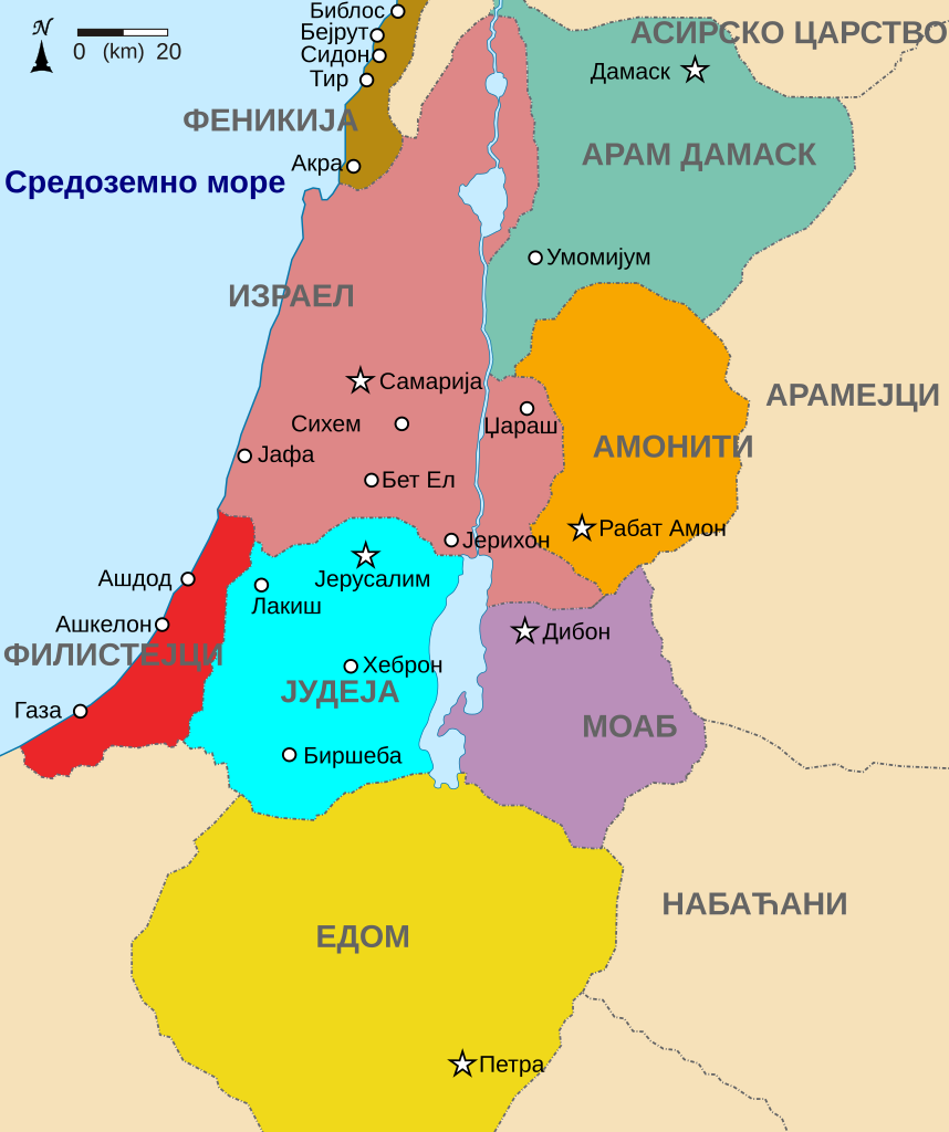
English: Map showing states around Israel and Judah. The Kingdoms around Israel and Judah are colored: * Phoenicia -Brown * Aram Damascus - Aquamarine * Amon - Orange * Moab - Purple * Edom - Yellow * Philistia - Red The map shows the region in the 9th century BCE. |
| Date | (UTC) |
| Source | |
| Author |
|
| Other versions |
[]
|


| This is a retouched picture, which means that it has been digitally altered from its original version. Modifications: translated to serbian. The original can be viewed here: Kingdoms around Israel 830 map.svg:
|

|
This SVG file contains embedded text that can be translated into your language, using any capable SVG editor, text editor or the SVG Translate tool. For more information see: About translating SVG files. |
This file is licensed under the Creative Commons Attribution-Share Alike 3.0 Unported license.
- You are free:
- to share – to copy, distribute and transmit the work
- to remix – to adapt the work
- Under the following conditions:
- attribution – You must give appropriate credit, provide a link to the license, and indicate if changes were made. You may do so in any reasonable manner, but not in any way that suggests the licensor endorses you or your use.
- share alike – If you remix, transform, or build upon the material, you must distribute your contributions under the same or compatible license as the original.
Original upload log[edit]
This image is a derivative work of the following images:
- File:Kingdoms_around_Israel_830_map.svg licensed with Cc-by-sa-3.0, GFDL
- 2010-07-13T12:58:31Z Richardprins 720x859 (169373 Bytes) livened up the colors, converted med sea text to path
- 2010-07-13T11:26:40Z Richardprins 720x859 (141985 Bytes) {{Information |Description={{en|1=Map showing the ancient levant borders and ancient cities such as [[Urmomium]] and [[Jerash]]. The Kingdoms around Israel and Judah are colored. The map also shows the region in the 9th centu
Uploaded with derivativeFX
File history
Click on a date/time to view the file as it appeared at that time.
| Date/Time | Thumbnail | Dimensions | User | Comment | |
|---|---|---|---|---|---|
| current | 04:27, 7 August 2011 | | 720 × 859 (62 KB) | BokicaK (talk | contribs) | терминологија |
| 03:30, 27 July 2011 |  | 720 × 859 (62 KB) | BokicaK (talk | contribs) | {{Information |Description={{en|1=Map showing states around Israel and Judah. The Kingdoms around Israel and Judah are colored: * Phoenicia -Brown * Aram Damascus - Aquamarine * Amon - Orange * Moab - Purple * Edom - Yellow * Philistia - Red The map show |
You cannot overwrite this file.
File usage on Commons
The following 28 pages use this file:
- File:Amón 830-es.svg
- File:Edom 830-es.svg
- File:Kingdoms around Israel 830 map-el.svg
- File:Kingdoms around Israel 830 map-nl.svg
- File:Kingdoms around Israel 830 map-pt.svg
- File:Kingdoms around Israel 830 map.svg
- File:Kingdoms around Israel 830 map mk.svg
- File:Kingdoms around Israel 830 map sh.svg
- File:Kingdoms around Israel 830 map sr.svg
- File:Kingdoms of Israel and Judah map 830-ar.svg
- File:Kingdoms of Israel and Judah map 830-el.svg
- File:Kingdoms of Israel and Judah map 830-es.svg
- File:Kingdoms of Israel and Judah map 830-hu.svg
- File:Kingdoms of Israel and Judah map 830-nl.svg
- File:Kingdoms of Israel and Judah map 830-pt.svg
- File:Kingdoms of Israel and Judah map 830.svg
- File:Kingdoms of Israel and Judah map 830 zh.svg
- File:Levant 830-HE-2.svg
- File:Levant 830-HE.svg
- File:Levant 830-rus.svg
- File:Levant 830.svg
- File:Levant 830 map-pt.svg
- File:Levant hu.svg
- File:Levante 830-es.svg
- File:Moab 830-es.svg
- File:Royaumes autour d'Israel en 830.svg
- File:イスラエル王国とユダ王国.svg
- Template:Other versions/Kingdoms around Israel 830 map
File usage on other wikis
The following other wikis use this file:
- Usage on sr.wikipedia.org