File:Kingdoms around Israel 830 map-nl.svg
Jump to navigation
Jump to search

Size of this PNG preview of this SVG file: 502 × 599 pixels. Other resolutions: 201 × 240 pixels | 402 × 480 pixels | 644 × 768 pixels | 858 × 1,024 pixels | 1,717 × 2,048 pixels | 720 × 859 pixels.
Original file (SVG file, nominally 720 × 859 pixels, file size: 479 KB)
Captions
Captions
Add a one-line explanation of what this file represents
Summary[edit]
| Description |
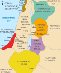
Nederlands: Kaart van de koninkrijken rondom Israël omstreeks 830 v.Chr. De plaatsnamen beantwoorden aan de conventies van de Katholieke Bijbelstichting en het Nederlands Bijbelgenootschap (voor een lijst: zie Bijbelse namen, Nieuwe Bijbelvertaling). |
| Date | |
| Source | Own work |
| Author |
|
| Other versions |
[]
|


Licensing[edit]
I, the copyright holder of this work, hereby publish it under the following license:
This file is licensed under the Creative Commons Attribution-Share Alike 4.0 International license.
- You are free:
- to share – to copy, distribute and transmit the work
- to remix – to adapt the work
- Under the following conditions:
- attribution – You must give appropriate credit, provide a link to the license, and indicate if changes were made. You may do so in any reasonable manner, but not in any way that suggests the licensor endorses you or your use.
- share alike – If you remix, transform, or build upon the material, you must distribute your contributions under the same or compatible license as the original.
File history
Click on a date/time to view the file as it appeared at that time.
| Date/Time | Thumbnail | Dimensions | User | Comment | |
|---|---|---|---|---|---|
| current | 18:01, 4 March 2015 | | 720 × 859 (479 KB) | Wikibelgiaan (talk | contribs) | User created page with UploadWizard |
You cannot overwrite this file.
File usage on Commons
The following 29 pages use this file:
- File:Amón 830-es.svg
- File:Edom 830-es.svg
- File:Kingdoms around Israel 830 map-el.svg
- File:Kingdoms around Israel 830 map-nl.svg
- File:Kingdoms around Israel 830 map-nl zondertekst.svg (file redirect)
- File:Kingdoms around Israel 830 map-pt.svg
- File:Kingdoms around Israel 830 map.svg
- File:Kingdoms around Israel 830 map mk.svg
- File:Kingdoms around Israel 830 map sh.svg
- File:Kingdoms around Israel 830 map sr.svg
- File:Kingdoms of Israel and Judah map 830-ar.svg
- File:Kingdoms of Israel and Judah map 830-el.svg
- File:Kingdoms of Israel and Judah map 830-es.svg
- File:Kingdoms of Israel and Judah map 830-hu.svg
- File:Kingdoms of Israel and Judah map 830-nl.svg
- File:Kingdoms of Israel and Judah map 830-pt.svg
- File:Kingdoms of Israel and Judah map 830.svg
- File:Kingdoms of Israel and Judah map 830 zh.svg
- File:Levant 830-HE-2.svg
- File:Levant 830-HE.svg
- File:Levant 830-rus.svg
- File:Levant 830.svg
- File:Levant 830 map-pt.svg
- File:Levant hu.svg
- File:Levante 830-es.svg
- File:Moab 830-es.svg
- File:Royaumes autour d'Israel en 830.svg
- File:イスラエル王国とユダ王国.svg
- Template:Other versions/Kingdoms around Israel 830 map