File:Karte von Puchberg 6x.JPG
Jump to navigation
Jump to search
Size of this preview: 800 × 600 pixels. Other resolutions: 320 × 240 pixels | 640 × 480 pixels | 1,024 × 768 pixels | 1,280 × 960 pixels | 2,048 × 1,536 pixels.
Original file (2,048 × 1,536 pixels, file size: 560 KB, MIME type: image/jpeg)
Captions
Captions
Add a one-line explanation of what this file represents
Summary[edit]
| Description |
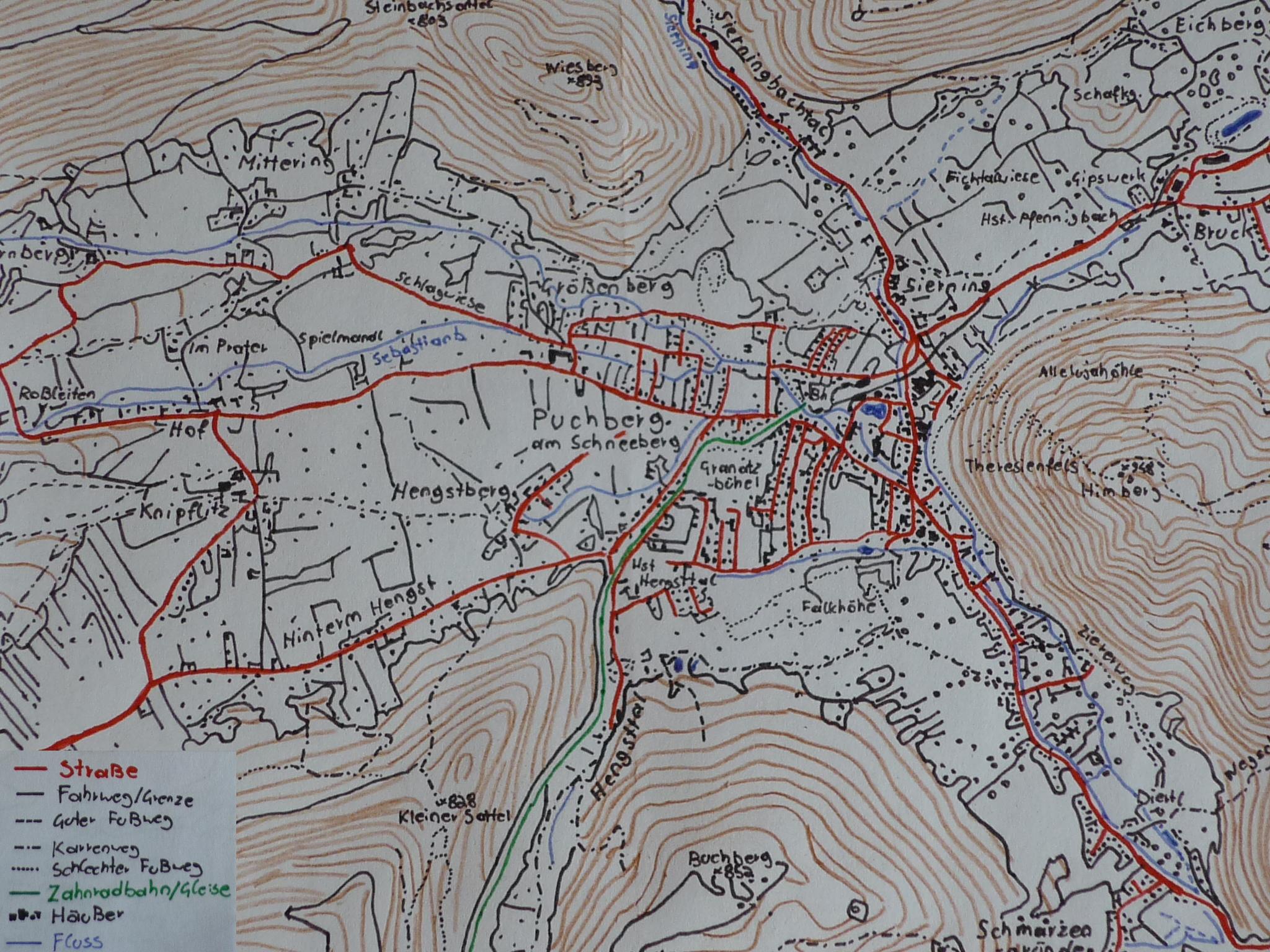
Deutsch: Das ist ein Karte vom Gemeindezentrum von Puchberg am Schneeberg. Zu sehen ist rechts der Himberg (1000 Höhenmeter) und die zwei Pforten, die nach und aus Puchberg führen. Weiter links (nicht eingezeichnet) steht der 2076 Meter hohe Schneeberg. |
| Date | |
| Source |
Own work Original text: eigene Karte und eigenes Foto |
| Author | Count_Dooku |
Licensing[edit]
This file is licensed under the Creative Commons Attribution-Share Alike 3.0 Unported license.
- You are free:
- to share – to copy, distribute and transmit the work
- to remix – to adapt the work
- Under the following conditions:
- attribution – You must give appropriate credit, provide a link to the license, and indicate if changes were made. You may do so in any reasonable manner, but not in any way that suggests the licensor endorses you or your use.
- share alike – If you remix, transform, or build upon the material, you must distribute your contributions under the same or compatible license as the original.

|
The copyright holder of this work allows anyone to use it for any purpose including unrestricted redistribution, commercial use, and modification.
Usage notes:
|
Original upload log[edit]
Transferred from de.wikipedia to Commons by Wdwdbot using script bot_filetrans.pl (r109M).
The original description page was here. All following user names refer to de.wikipedia.
- 2008-08-17 21:10:46 Count Dooku (573238 Bytes) {{Information |Beschreibung = Das ist ein Karte vom Gemeindezentrum von [[Puchberg am Schneeberg]]. Zu sehen ist rechts der Himberg (1000 Höhenmeter) und die zwei Pforten, die nach und aus Puchberg führen. Weiter links (nicht eingezeichnet) steht der 20
File history
Click on a date/time to view the file as it appeared at that time.
| Date/Time | Thumbnail | Dimensions | User | Comment | |
|---|---|---|---|---|---|
| current | 18:41, 8 October 2018 | | 2,048 × 1,536 (560 KB) | Wdwdbot (talk | contribs) | Bot Move: Original uploader of this revision (#1) was Count Dooku at de.wikipedia |
You cannot overwrite this file.
File usage on Commons
There are no pages that use this file.
File usage on other wikis
The following other wikis use this file:
- Usage on de.wikipedia.org