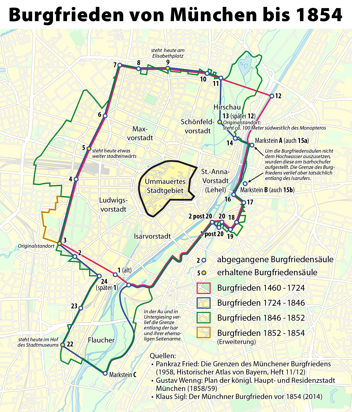
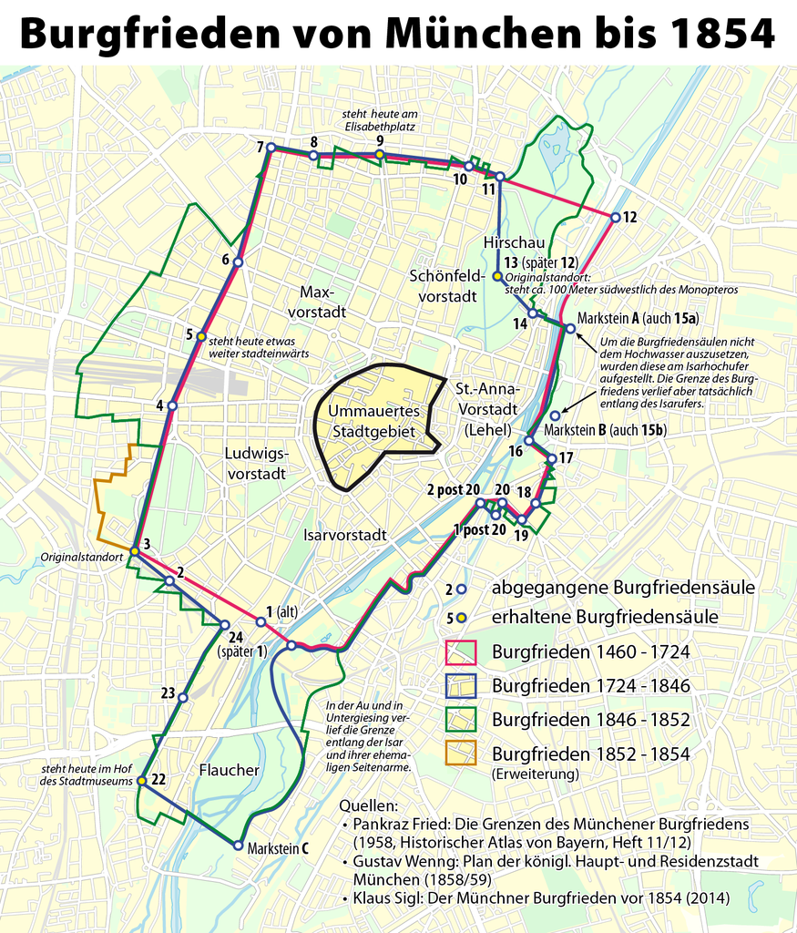
File:Karte der Burgfrieden von München.png
Jump to navigation
Jump to search
Size of this preview: 512 × 599 pixels. Other resolutions: 205 × 240 pixels | 410 × 480 pixels | 656 × 768 pixels | 875 × 1,024 pixels | 1,434 × 1,678 pixels.
Original file (1,434 × 1,678 pixels, file size: 1.38 MB, MIME type: image/png)
Captions
Captions
Add a one-line explanation of what this file represents
| Description |
|
| Date | see file history |
| Source |
Own work, using OpenStreetMap data for the background, and these maps for the Burgfrieden borderlines:
Further information: |
| Author | Maximilian Dörrbecker (Chumwa) |
| Permission (Reusing this file) |
All OpenStreetMap data and maps are Creative Commons "CC-BY-SA 2.0" licensed This file is licensed under the Creative Commons Attribution-Share Alike 2.0 Generic license.
|
| Other versions |
Region München:
Stadt München:
|


.png)


.png)
.png)


File history
Click on a date/time to view the file as it appeared at that time.
| Date/Time | Thumbnail | Dimensions | User | Comment | |
|---|---|---|---|---|---|
| current | 07:35, 29 May 2014 | | 1,434 × 1,678 (1.38 MB) | Chumwa (talk | contribs) | |
| 16:38, 19 April 2014 |  | 1,434 × 1,678 (1.38 MB) | Chumwa (talk | contribs) | ||
| 23:06, 17 April 2014 |  | 1,434 × 1,678 (1.38 MB) | Chumwa (talk | contribs) | ||
| 21:47, 9 July 2013 |  | 1,797 × 2,057 (1.92 MB) | Chumwa (talk | contribs) | . | |
| 21:31, 9 July 2013 |  | 1,797 × 2,057 (1.84 MB) | Chumwa (talk | contribs) | . | |
| 17:01, 7 July 2013 |  | 1,797 × 2,057 (1.96 MB) | Chumwa (talk | contribs) | . | |
| 17:14, 28 May 2013 |  | 1,797 × 2,057 (1.75 MB) | Chumwa (talk | contribs) | . | |
| 17:01, 28 May 2013 |  | 1,797 × 2,057 (1.76 MB) | Chumwa (talk | contribs) | corr | |
| 22:03, 27 May 2013 |  | 1,797 × 2,057 (1.76 MB) | Chumwa (talk | contribs) | . | |
| 21:30, 27 May 2013 |  | 1,797 × 2,057 (1.77 MB) | Chumwa (talk | contribs) | {{Information |Description= *{{de|Karte der Burgfrieden von München}} |Author=Maximilian Dörrbecker (Chumwa) |Source={{own}}, using OpenStreetMap data for the background |Date=see file history |Permission=... |
You cannot overwrite this file.
File usage on Commons
The following 35 pages use this file:
- Münchner Burgfrieden
- User:Chumwa/Gallery
- User:Chumwa/OtherVersions - Karten München
- File:Administrative boundaries of the borough of Solln in Munich.png
- File:Basiskarte Kiel.png
- File:Karte Flaucher München.png
- File:Karte München - WirtshausWiesn 2020.png
- File:Karte München Basiskarte.jpg
- File:Karte München Basiskarte.png
- File:Karte München Landnutzung.png
- File:Karte München Schwarzplan.png
- File:Karte München ÖPNV.png
- File:Karte München Übersichtsplan.png
- File:Karte Streetlife München.png
- File:Karte Viktualienmarkt München.png
- File:Karte der Burgfrieden von München.png
- File:Karte der Denkmalschutzensembles in München.jpg
- File:Karte der Gemarkungen in München.png
- File:Karte der Gemarkungen und Stadtbezirke in München.png
- File:Karte der Ortsbezeichnungen in München.png
- File:Karte der Parkstadt Bogenhausen in München.png
- File:Karte der Stadtbezirke in München.png
- File:Karte der Stadtbezirke in München in der bis 1992 gültigen Gliederung.png
- File:Karte der Stadtbezirksteile in München.png
- File:München - Basiskarte farbig.pdf
- File:München - Basiskarte farbig.png
- File:München - Basiskarte farbig - mit Nachbargemeinden.jpg
- File:München - Basiskarte farbig - mit Nachbargemeinden.png
- File:München - Basiskarte grau.pdf
- File:München - Basiskarte grau.png
- File:München - Stadtbezirke (Karte).png
- File:Positionskarte München.png
- File:Stadterweiterungen München.png
- File:Westpark München (Karte).png
- File:Westpark München zur IGA 1983 (Karte).png
File usage on other wikis
The following other wikis use this file:
- Usage on de.wikipedia.org
- Usage on en.wikipedia.org