File:Karte Zweite Stammstrecke Muenchen.png
Jump to navigation
Jump to search
Size of this preview: 670 × 599 pixels. Other resolutions: 268 × 240 pixels | 537 × 480 pixels | 859 × 768 pixels | 1,145 × 1,024 pixels | 2,290 × 2,048 pixels | 4,994 × 4,466 pixels.
Original file (4,994 × 4,466 pixels, file size: 6.24 MB, MIME type: image/png)
Captions
Captions
Add a one-line explanation of what this file represents
| Description |
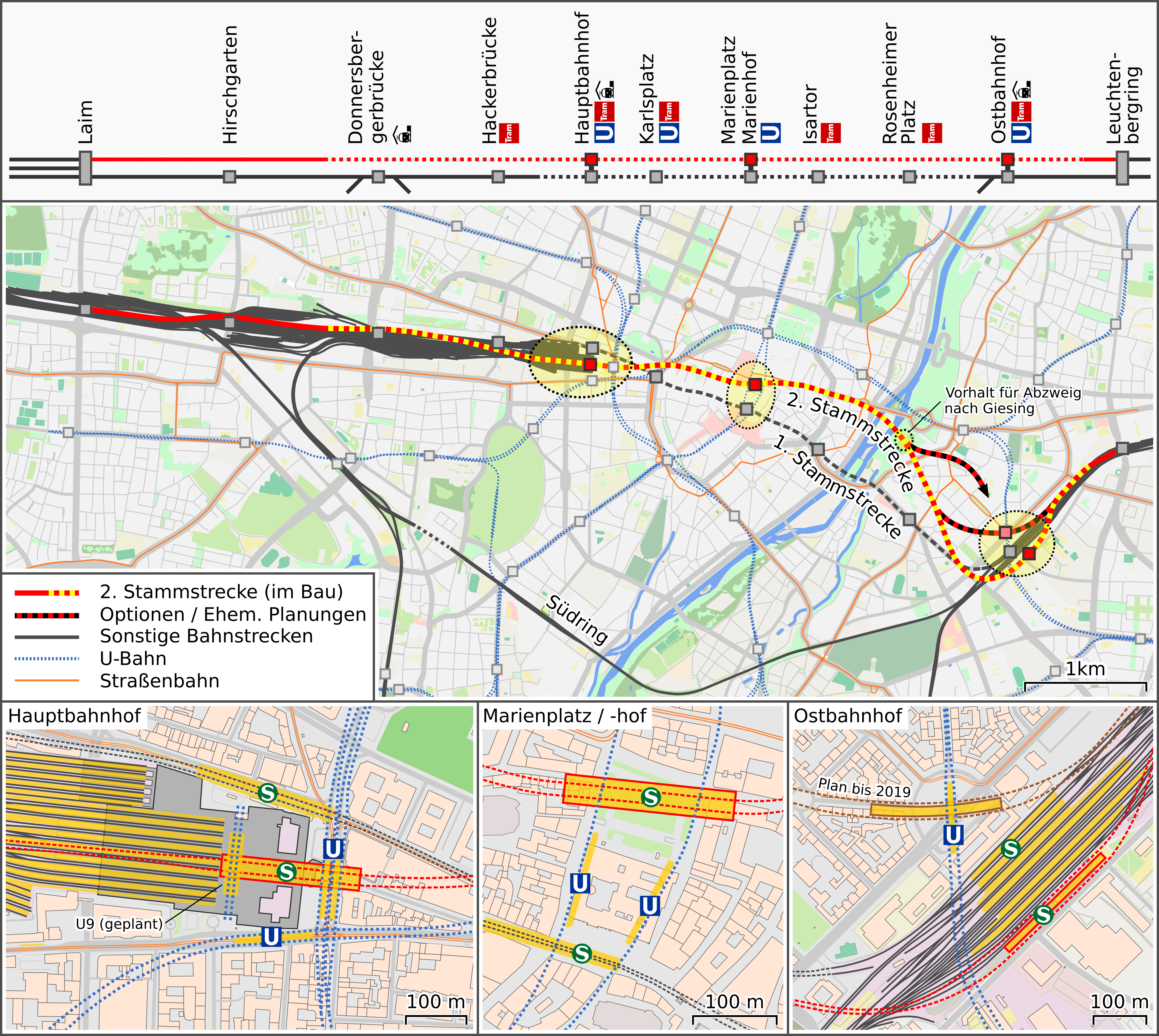
Deutsch: Karte der geplanten Zweiten Stammstrecke der Münchner S-Bahn |
| Date | |
| Source | OpenStreetMap data exported and adapted by myself |
| Author |
|
This file is licensed under the Creative Commons Attribution-Share Alike 2.0 Generic license.
- You are free:
- to share – to copy, distribute and transmit the work
- to remix – to adapt the work
- Under the following conditions:
- attribution – You must give appropriate credit, provide a link to the license, and indicate if changes were made. You may do so in any reasonable manner, but not in any way that suggests the licensor endorses you or your use.
- share alike – If you remix, transform, or build upon the material, you must distribute your contributions under the same or compatible license as the original.
File history
Click on a date/time to view the file as it appeared at that time.
| Date/Time | Thumbnail | Dimensions | User | Comment | |
|---|---|---|---|---|---|
| current | 15:34, 30 April 2020 | | 4,994 × 4,466 (6.24 MB) | Vuxi (talk | contribs) | Umplanung am Ostbahnhof |
| 14:11, 16 April 2017 |  | 4,994 × 4,466 (6.17 MB) | Vuxi (talk | contribs) | Vorhalt Abzweig nach Giesing; Anpassung Marienhof | |
| 18:51, 14 December 2015 |  | 4,994 × 4,466 (6.11 MB) | Vuxi (talk | contribs) | {{Information |description={{de|1=Karte der geplanten Zweiten Stammstrecke der Münchner S-Bahn}} |date=2015-12-14 |source=OpenStreetMap data exported and adapted by myself |author=*map by OpenStreetMap contributors, All OpenStreetMap data and maps are... |
You cannot overwrite this file.
File usage on Commons
The following 8 pages use this file:
- User:Chumwa/OgreBot/München/2015 December 11-20
- User:Chumwa/OgreBot/München/2017 April 11-20
- User:Chumwa/OgreBot/Public transport information/2015 December 11-20
- User:Chumwa/OgreBot/Public transport information/2020 April 21-30
- User:Chumwa/OgreBot/Transport Maps/2015 December 11-20
- User:Chumwa/OgreBot/Transport Maps/2020 April 21-30
- User:Nordlicht8/Rail Germany/2015 December 11-20
- Category:Stammstrecke 2 (S-Bahn München)
File usage on other wikis
The following other wikis use this file:
- Usage on de.wikipedia.org
- Usage on en.wikipedia.org
- Usage on hu.wikipedia.org
- Usage on www.wikidata.org