File:Karte Westliche Berliner Vorortbahn.png
Jump to navigation
Jump to search
Size of this preview: 712 × 600 pixels. Other resolutions: 285 × 240 pixels | 570 × 480 pixels | 912 × 768 pixels | 1,216 × 1,024 pixels | 2,432 × 2,048 pixels | 4,387 × 3,694 pixels.
Original file (4,387 × 3,694 pixels, file size: 25.58 MB, MIME type: image/png)
Captions
Captions
Add a one-line explanation of what this file represents
Summary[edit]
| Description |
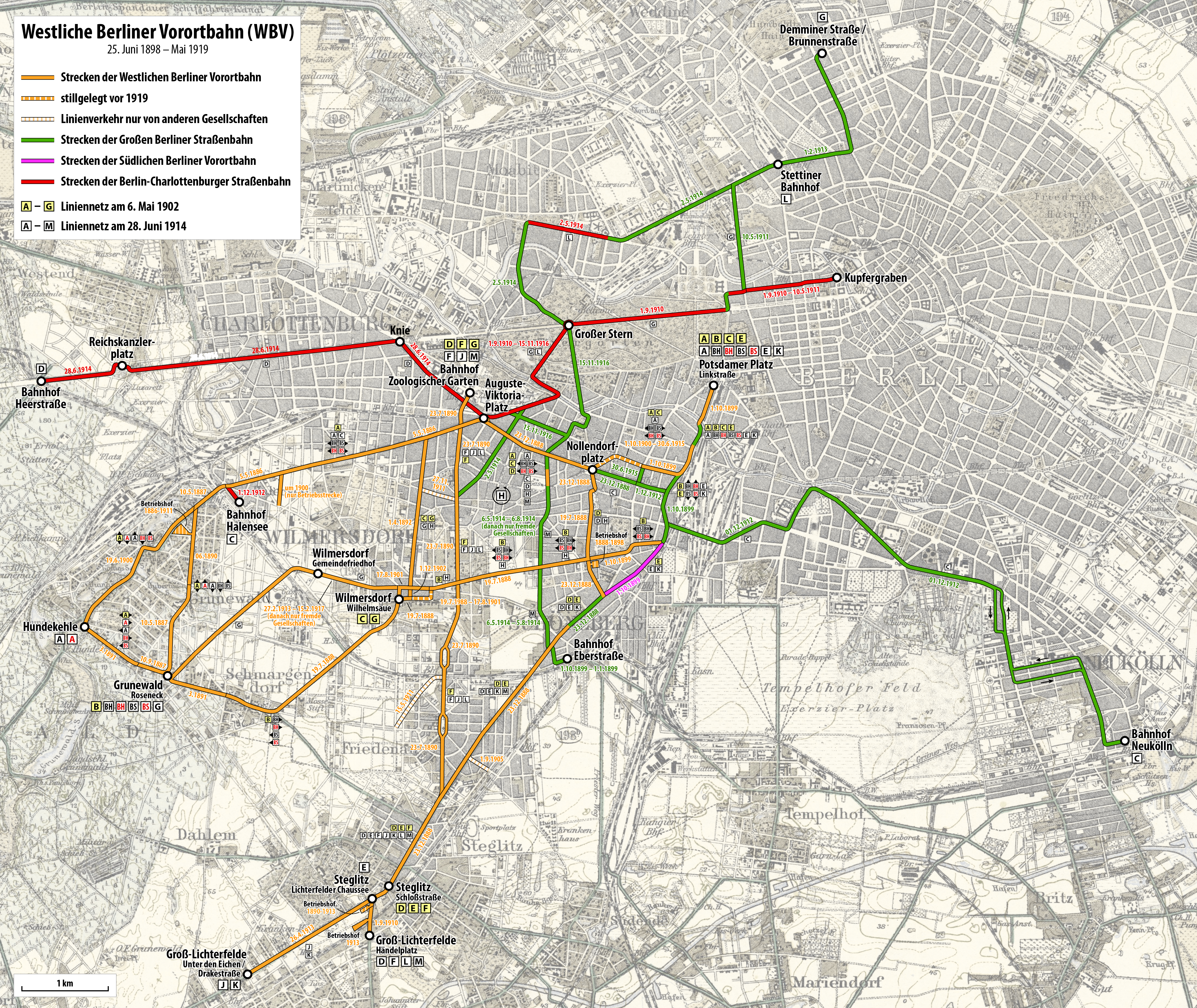
Deutsch: Karte der Westlichen Berliner Vorortbahn (1898-1919) |
| Date | see file history |
| Source |
Own work using:
|
| Author | Maximilian Dörrbecker (Chumwa) |
| Permission (Reusing this file) |
I, the copyright holder of this work, hereby publish it under the following license: This file is licensed under the Creative Commons Attribution-Share Alike 2.5 Generic license.
Sie dürfen das Bild zu den folgenden Bedingungen nutzen:
|
_in_12_Bl%C3%A4ttern_VI_Berlin.jpg)
File history
Click on a date/time to view the file as it appeared at that time.
| Date/Time | Thumbnail | Dimensions | User | Comment | |
|---|---|---|---|---|---|
| current | 21:50, 20 May 2019 | | 4,387 × 3,694 (25.58 MB) | Chumwa (talk | contribs) | corr |
| 20:50, 3 November 2017 |  | 4,387 × 3,694 (25.58 MB) | Chumwa (talk | contribs) | ||
| 17:10, 20 October 2017 |  | 4,387 × 3,694 (25.58 MB) | Chumwa (talk | contribs) | corr, erg | |
| 16:25, 15 October 2017 |  | 4,387 × 3,694 (25.59 MB) | Chumwa (talk | contribs) | corr | |
| 18:25, 9 October 2017 |  | 4,387 × 3,694 (25.59 MB) | Chumwa (talk | contribs) | corr | |
| 16:51, 9 October 2017 |  | 4,387 × 3,694 (25.59 MB) | Chumwa (talk | contribs) | corr | |
| 16:22, 8 October 2017 |  | 4,387 × 3,694 (25.42 MB) | Chumwa (talk | contribs) | corr | |
| 05:16, 6 October 2017 |  | 2,072 × 1,766 (4.21 MB) | Chumwa (talk | contribs) | == {{int:filedesc}} == {{Information | Description = {{de|1=Karte der Westlichen Berliner Vorortbahn (1898-1919)}} |Source = {{own using}} * a sketch by {{U|Platte}} * [[:File:Straube Droschken-Wegemesser für die Umgebung von Berlin 1888.jpg|... |
You cannot overwrite this file.
File usage on Commons
The following 17 pages use this file:
- User:Chumwa/Gallery
- User:Chumwa/OgreBot/Potential transport maps/2017 November 1-10
- User:Chumwa/OgreBot/Potential transport maps/2017 October 1-10
- User:Chumwa/OgreBot/Potential transport maps/2017 October 11-20
- User:Chumwa/OgreBot/Potential transport maps/2019 May 11-20
- User:Chumwa/OgreBot/Public transport information/2017 November 1-10
- User:Chumwa/OgreBot/Public transport information/2017 October 1-10
- User:Chumwa/OgreBot/Public transport information/2017 October 11-20
- User:Chumwa/OgreBot/Public transport information/2019 May 11-20
- User:Chumwa/OgreBot/Transport Maps/2017 November 1-10
- User:Chumwa/OgreBot/Transport Maps/2017 October 1-10
- User:Chumwa/OgreBot/Transport Maps/2017 October 11-20
- User:Chumwa/OgreBot/Transport Maps/2019 May 11-20
- User:Chumwa/OgreBot/Travel and communication maps/2017 November 1-10
- User:Chumwa/OgreBot/Travel and communication maps/2017 October 1-10
- User:Chumwa/OgreBot/Travel and communication maps/2017 October 11-20
- User:Chumwa/OgreBot/Travel and communication maps/2019 May 11-20
File usage on other wikis
The following other wikis use this file:
- Usage on de.wikipedia.org
- Usage on uk.wikipedia.org