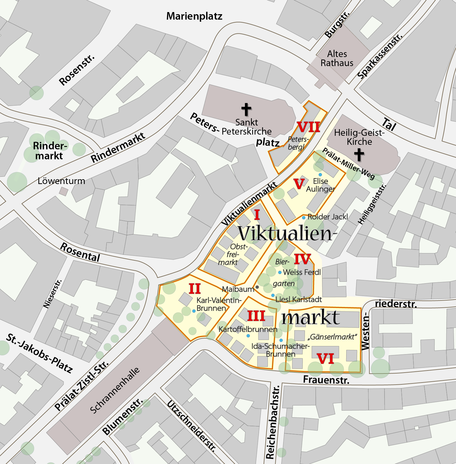
File:Karte Viktualienmarkt München.png
Jump to navigation
Jump to search
Size of this preview: 589 × 599 pixels. Other resolutions: 236 × 240 pixels | 472 × 480 pixels | 755 × 768 pixels | 1,007 × 1,024 pixels | 1,512 × 1,538 pixels.
Original file (1,512 × 1,538 pixels, file size: 667 KB, MIME type: image/png)
Captions
Captions
Add a one-line explanation of what this file represents
| Description |
|
| Date | see file history |
| Source | Own work, using OpenStreetMap data for the background. |
| Author | Maximilian Dörrbecker (Chumwa) |
| Permission (Reusing this file) |
All OpenStreetMap data and maps are Creative Commons "CC-BY-SA 2.0" licensed This file is licensed under the Creative Commons Attribution-Share Alike 2.0 Generic license.
|
| Other versions |
Region München:
Stadt München:
|


.png)


.png)
.png)


File history
Click on a date/time to view the file as it appeared at that time.
| Date/Time | Thumbnail | Dimensions | User | Comment | |
|---|---|---|---|---|---|
| current | 19:45, 31 July 2013 | | 1,512 × 1,538 (667 KB) | Chumwa (talk | contribs) | . |
| 19:52, 30 July 2013 |  | 1,512 × 1,538 (669 KB) | Chumwa (talk | contribs) | . | |
| 18:41, 30 July 2013 |  | 1,512 × 1,538 (587 KB) | Chumwa (talk | contribs) | {{Information |Description= *{{de|Plan des Viktualienmarkts in München}} |Author=Maximilian Dörrbecker (Chumwa) |Source={{own}}, using OpenStreetMap data for the background. |Date=see file history |Permiss... |
You cannot overwrite this file.
File usage on Commons
The following 36 pages use this file:
- Viktualienmarkt (München)
- User:Chumwa/Gallery
- User:Chumwa/OtherVersions - Karten München
- File:Administrative boundaries of the borough of Solln in Munich.png
- File:Basiskarte Kiel.png
- File:Karte Flaucher München.png
- File:Karte München - WirtshausWiesn 2020.png
- File:Karte München Basiskarte.jpg
- File:Karte München Basiskarte.png
- File:Karte München Landnutzung.png
- File:Karte München Schwarzplan.png
- File:Karte München ÖPNV.png
- File:Karte München Übersichtsplan.png
- File:Karte Streetlife München.png
- File:Karte Viktualienmarkt München.png
- File:Karte der Burgfrieden von München.png
- File:Karte der Denkmalschutzensembles in München.jpg
- File:Karte der Gemarkungen in München.png
- File:Karte der Gemarkungen und Stadtbezirke in München.png
- File:Karte der Ortsbezeichnungen in München.png
- File:Karte der Parkstadt Bogenhausen in München.png
- File:Karte der Stadtbezirke in München.png
- File:Karte der Stadtbezirke in München in der bis 1992 gültigen Gliederung.png
- File:Karte der Stadtbezirksteile in München.png
- File:München - Basiskarte farbig.pdf
- File:München - Basiskarte farbig.png
- File:München - Basiskarte farbig - mit Nachbargemeinden.jpg
- File:München - Basiskarte farbig - mit Nachbargemeinden.png
- File:München - Basiskarte grau.pdf
- File:München - Basiskarte grau.png
- File:München - Stadtbezirke (Karte).png
- File:Positionskarte München.png
- File:Stadterweiterungen München.png
- File:Westpark München (Karte).png
- File:Westpark München zur IGA 1983 (Karte).png
- Category:Viktualienmarkt (München)
File usage on other wikis
The following other wikis use this file:
- Usage on bn.wikipedia.org
- Usage on de.wikipedia.org
- Usage on en.wikipedia.org
- Usage on es.wikipedia.org
- Usage on eu.wikipedia.org
- Usage on fr.wikipedia.org
- Usage on it.wikipedia.org
- Usage on pl.wikipedia.org
- Usage on ru.wikipedia.org
- Usage on www.wikidata.org
- Usage on zh.wikipedia.org